METAR & TAF 7W5
7W5 does not publish a METAR.
Showing the nearest reporting station: KUSE (FULTON COUNTY) · 14.4 NM away. Conditions at 7W5 may differ.
METAR · KUSE
Observed 16:55Z
KUSE 271655Z AUTO 24009G15KT 10SM CLR 27/23 A2982 RMK AO2
- Wind
- 240° @ 9G15 kt
- Visibility
- 10 SM
- Temp / Dew
- 27°C / 23°C
- Altimeter
- 29.82 inHg
- Clouds
- CLR
- Density alt
- 2,411 ft
- Ceiling
- Unlimited
- Rules
- VFR
Airport info & contacts
Manager on record, flight service, ARTCC, attendance schedule and pattern altitude — published by the FAA and refreshed every 28 days.
Location
- From city
- 3 NM E
- VFR sectional
- DETROIT
- ARTCC
- ZOB · CLEVELAND
- NOTAM facility
- CLE (NOTAM-D)
Airport manager
- Name
- JARED AMES, ACTING AMGR
- Phone
- 419-599-6494
- Address
- 10646 COUNTY ROAD O, NAPOLEON OH 43545-6217
Flight service · Hours
- FSS CLE
- CLEVELAND1-800-WX-BRIEF
- Attendance
- MON-FRI · 0800-1730
- SAT-SUN · ON CALL
Frequencies
Tap any row to copy the frequency to your clipboard.
Runways & pattern
Full pagePattern entry · RWY 28
LEFT TRAFFICRunway end performance
| End | TORA | TODA | ASDA | LDA | VGSI | Approach lights | Obstruction |
|---|---|---|---|---|---|---|---|
| 10 | — | — | — | — | PAPI 2-box left(3°) | — | 5', crops, 200' from thr, 95' R of cntrln, slope 0 |
| 28 | — | — | — | — | PAPI 2-box left(3°) | — | 6', crops, 200' from thr, 125' R of cntrln, slope 0 |
Declared distances in feet. TORA = takeoff run available, TODA = takeoff distance, ASDA = accelerate-stop, LDA = landing distance.
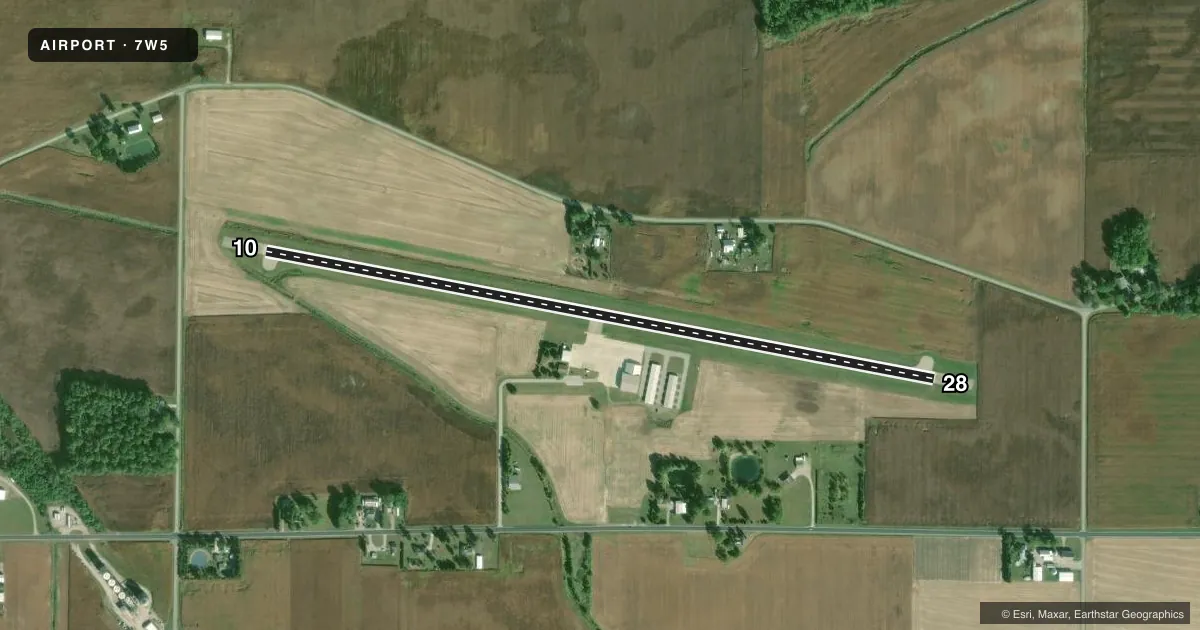
Airport sketch
Runways drawn to scale from FAA survey coordinates, rendered over satellite imagery. Not for navigation.
Approaches & charts
Services on the field
Fuel grades, oxygen, maintenance, ramp storage and lighting — as declared to the FAA by the airport operator.
Fuel & services
- Fuel
- 100LLA
- Oxygen (bottled)
- Low pressure
- Oxygen (bulk)
- Not available
- Airframe repair
- Major
- Power plant repair
- Major
- Other services
- SALES
Ramp & ground
- Transient storage
- Tie-down
- Hangar
- Landing fee
- No fee published
- Customs
- Not available
- Lighting schedule
- SEE RMK
- Beacon schedule
- SS-SR
- Beacon
- White / Green (civil land)(WG)
- Wind indicator
- Lighted
- Segmented circle
- No
Fuel & FBOs
Cheapest 100LL and Jet A on the field and nearby. Always confirm with the FBO before taxi.
Airport notes
Surface conditions, obstructions, local procedures, lighting outages and other notes published with each FAA cycle.
General notes
- FOR CD CTC TOLEDO APCH AT 419-865-1495.
Lighting notes
- ACTVT REIL RWY 10 & 28; PAPI RWY 10 & 28; MIRL RWY 10/28 - CTAF.
Approach & departure obstructions
- 10+5 FT CROPS/CULTIVATED FLD, 140-200 FT DIST, 95-125 FT R.
- 28+6 FT CROPS/CULTIVATED FLD, 0-200 FT DIST, 125 FT L TO 130 FT R.
- 10CTLG OBSTN EXCEEDS A 45 DEG SLP.
- 28CTLG OBSTN EXCEEDS A 45 DEG SLP.
Other notes
- PRIOR CDN RQRD.
- 2FOR SVC CALL AMGR CELL.
- MANAGERCELL 419-388-9259.
VFR map & nearby airports
VFR sectional. Tap any ICAO chip to open that airport.
Key facts · 7W5
Answer card- ICAO
- 7W5
- Name
- HENRY COUNTY
- Location
- NAPOLEON, OHIO
- Elevation
- 682.9 ft MSL
- Traffic pattern altitude
- 1,682.9 ft MSL (1,000 AGL)
- Control tower
- Non-towered (use CTAF)
- Total runways
- 1
- Longest runway
- 10/28 · 4,001 ft
- Published ILS approaches
- 0
- Published frequencies
- 4
- Magnetic variation
- 5°
- Current flight rules
- VFR
- Current wind
- 240° at 9 kt
- Favored runway now
- RWY 28
Henry County Airport is in Napoleon, Ohio. The field elevation is 682.9 ft MSL. It has one runway, 10/28, which is 4,001 ft long. There is no control tower. CTAF and UNICOM are both 123.0. Toledo Approach uses 134.35 and 307.0 for approach and departure work. No ILS approaches are published here.
Pattern altitude is not published. Use the standard 1,000 ft AGL pattern unless local procedures or ATC say otherwise. Runway lighting is available on 10/28. The runway ends also have REILs and PAPI. That helps at night or in lower visibility. You still want to brief the field before arrival.
Ames Aviation is on the field. It carries 100LL, Jet A and Jet A Prist. For services, the published remarks say to call the airport manager first. Prior coordination is required. That matters here because the Chart Supplement also notes crops and cultivated field close to both runway ends. Obstacles are published near the departure ends of 10 and 28. Treat the runway environment with care on takeoff and landing. If you need clearance delivery, contact Toledo Approach at 419-865-1495 before departure.