METAR & TAF KOWX
Current METAR
Observed 13:35Z
KOWX 271335Z AUTO 25009KT 9SM CLR 24/24 A2994 RMK AO2
- Wind
- 250° @ 9 kt
- Visibility
- 9 SM
- Temp / Dew
- 24°C / 24°C
- Altimeter
- 29.94 inHg
- Clouds
- CLR
- Density alt
- 2,002 ft
- Ceiling
- Unlimited
- Rules
- VFR
Airport info & contacts
Manager on record, flight service, ARTCC, attendance schedule and pattern altitude — published by the FAA and refreshed every 28 days.
Location
- From city
- 3 NM NE
- VFR sectional
- DETROIT
- ARTCC
- ZOB · CLEVELAND
- NOTAM facility
- OWX (NOTAM-D)
Airport manager
- Name
- CHAD & LINDA NIESE
- Phone
- 419-523-3910
- Address
- 10218 ROAD 5-H, OTTAWA OH 45875-9715
Flight service · Hours
- FSS CLE
- CLEVELAND1-800-WX-BRIEF
- Attendance
- MON-FRI · 0900-1700
Frequencies
Tap any row to copy the frequency to your clipboard.
Runways & pattern
Full pagePattern entry · RWY 27
LEFT TRAFFICRunway end performance
| End | TORA | TODA | ASDA | LDA | VGSI | Approach lights | Obstruction |
|---|---|---|---|---|---|---|---|
| 09 | — | — | — | — | PAPI 2-box left(3°) | — | 16', road, 201' from thr, 217' R of cntrln, slope 0 |
| 27 | — | — | — | — | PAPI 2-box left(3°) | — | 11', road, 201' from thr, 208' R of cntrln, slope 0 |
Declared distances in feet. TORA = takeoff run available, TODA = takeoff distance, ASDA = accelerate-stop, LDA = landing distance.
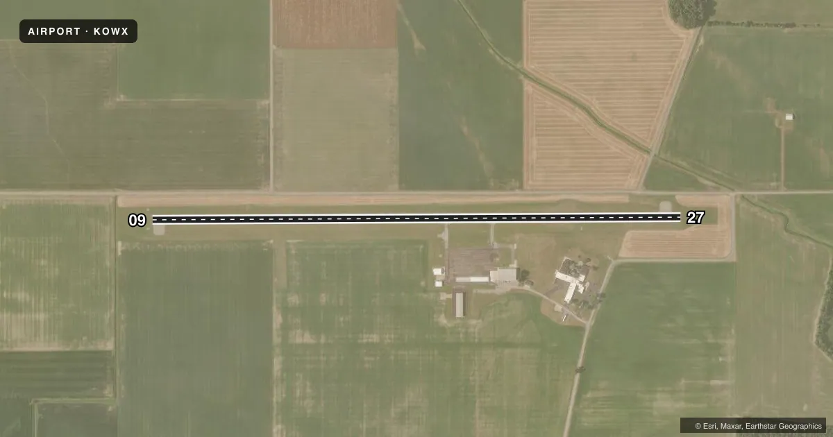
Airport sketch
Runways drawn to scale from FAA survey coordinates, rendered over satellite imagery. Not for navigation.
Approaches & charts
Services on the field
Fuel grades, oxygen, maintenance, ramp storage and lighting — as declared to the FAA by the airport operator.
Fuel & services
- Fuel
- 100LLA+
- Oxygen (bottled)
- Not available
- Oxygen (bulk)
- Not available
- Airframe repair
- Not available
- Power plant repair
- Not available
- Other services
- AGRI
Ramp & ground
- Transient storage
- Tie-down
- Hangar
- Landing fee
- No fee published
- Customs
- Not available
- Lighting schedule
- SEE RMK
- Beacon schedule
- SS-SR
- Beacon
- White / Green (civil land)(WG)
- Wind indicator
- Lighted
- Segmented circle
- No
Fuel & FBOs
Cheapest 100LL and Jet A on the field and nearby. Always confirm with the FBO before taxi.
Airport notes
Surface conditions, obstructions, local procedures, lighting outages and other notes published with each FAA cycle.
General notes
- INTENSIVE AGRI OPNS & CROP DUSTING.
- FOR CD CTC TOLEDO APCH AT 419-865-1495.
Lighting notes
- ACTVT REIL RWY 09 & 27; MIRL RWY 09/27 - CTAF. PAPI RWY 09 & 27 OPR CONSLY.
Fuel notes
- 100LLFUEL AVBL H24 SELF SVC.
Approach & departure obstructions
- 09+9 FT ROAD, 0-200 FT DIST, 217 FT L.
- 27+11 FT ROAD, 0-200 FT DIST, 208 FT R.
Other notes
- PRIOR CDN RQRD.
- 1FOR SVC ALL HRS CALL AMGR.
VFR map & nearby airports
VFR sectional. Tap any ICAO chip to open that airport.
Key facts · KOWX
Answer card- ICAO
- KOWX
- Name
- PUTNAM COUNTY
- Location
- OTTAWA, OHIO
- Elevation
- 763.5 ft MSL
- Traffic pattern altitude
- 1,763.5 ft MSL (1,000 AGL)
- Control tower
- Non-towered (use CTAF)
- Total runways
- 1
- Longest runway
- 09/27 · 4,502 ft
- Published ILS approaches
- 0
- Published frequencies
- 4
- Magnetic variation
- 5°
- Current flight rules
- VFR
- Current wind
- 250° at 9 kt
- Favored runway now
- RWY 27
Putnam County Airport (KOWX) sits in Ottawa, Ohio. Field elevation is 763.5 ft MSL. The airport has one runway, 09/27, which is 4,502 ft long and asphalt. There is no control tower. No ILS approaches are published. Pattern altitude is not published, so use 1,000 ft AGL for light piston traffic unless the current Chart Supplement says otherwise.
The on-field FBO is Putnam County Airport. It carries 100LL and Jet A. Fuel is available 24 hours a day self-serve. Prior coordination is required. For service at all hours, call the airport manager. Clearance delivery is handled by Toledo Approach at 419-865-1495.
This field has a few things a first-time pilot should plan for. Intensive agricultural operations and crop dusting occur in the area. There is an 11-foot road obstruction near the departure end of runway 27, 208 feet right of centerline. There is also a 9-foot road obstruction near the departure end of runway 09, 217 feet left of centerline. Runway end identifier lights are on 09 and 27. Medium intensity runway lights are CTAF-controlled. PAPI is available on both ends and operates continuously. Check the current FAA Chart Supplement before you go for any published restrictions or changes.