METAR & TAF KAOH
Current METAR
Observed 12:53Z
KAOH 271253Z AUTO 25007KT 8SM CLR 23/20 A2994 RMK AO2 SLP132 T02280200
- Wind
- 250° @ 7 kt
- Visibility
- 8 SM
- Temp / Dew
- 23°C / 20°C
- Altimeter
- 29.94 inHg
- Clouds
- CLR
- Density alt
- 2,145 ft
- Ceiling
- Unlimited
- Rules
- VFR
Airport info & contacts
Manager on record, flight service, ARTCC, attendance schedule and pattern altitude — published by the FAA and refreshed every 28 days.
Location
- From city
- 5 NM SE
- VFR sectional
- DETROIT
- ARTCC
- ZID · INDIANAPOLIS
- NOTAM facility
- AOH (NOTAM-D)
Airport manager
- Name
- JOSH TATTRIE
- Phone
- 419-227-3225
- Address
- 700 AIRPORT DR, LIMA OH 45804-4201
Flight service · Hours
- FSS DAY
- DAYTON1-800-WX-BRIEF
- Attendance
- MON-FRI · 0800-1700
- SAT · 0900-1600
- SUN · 1300-1700
Frequencies
Tap any row to copy the frequency to your clipboard.
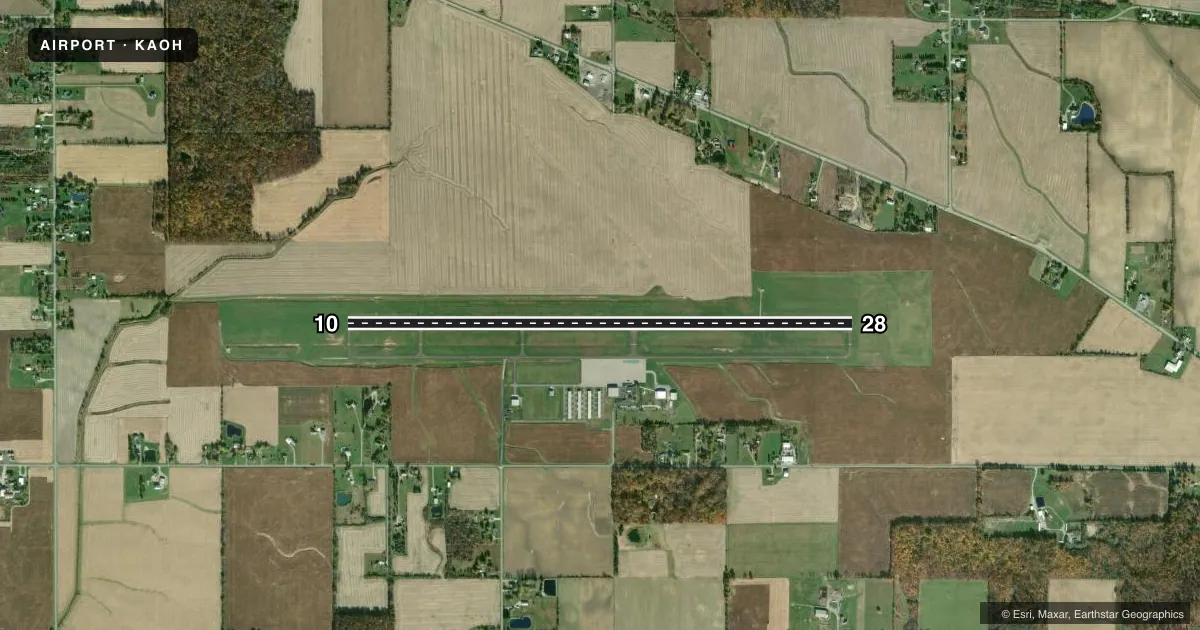
Runways & pattern
Full pagePattern entry · RWY 28
LEFT TRAFFICRunway end performance
| End | TORA | TODA | ASDA | LDA | VGSI | Approach lights | Obstruction |
|---|---|---|---|---|---|---|---|
| 10 | — | — | — | — | PAPI 4-box left(3°) | — | 63', trees, 2140' from thr, 193' R of cntrln, slope 30 |
| 28 | — | — | — | — | PAPI 4-box left(3°) | — | 47', tree, 1685' from thr, 361' R of cntrln, slope 31 |
Declared distances in feet. TORA = takeoff run available, TODA = takeoff distance, ASDA = accelerate-stop, LDA = landing distance.
Airport sketch
Runways drawn to scale from FAA survey coordinates, rendered over satellite imagery. Not for navigation.
Approaches & charts
ILS · 1
Services on the field
Fuel grades, oxygen, maintenance, ramp storage and lighting — as declared to the FAA by the airport operator.
Fuel & services
- Fuel
- 100LLA1+
- Oxygen (bottled)
- High pressure
- Oxygen (bulk)
- Not available
- Airframe repair
- Major
- Power plant repair
- Major
- Other services
- INSTR,RNTL,SALES
Ramp & ground
- Transient storage
- Tie-down
- Hangar
- Landing fee
- Yes
- Customs
- Not available
- Lighting schedule
- SEE RMK
- Beacon schedule
- SS-SR
- Beacon
- White / Green (civil land)(WG)
- Wind indicator
- Lighted
- Segmented circle
- Yes
Fuel & FBOs
Cheapest 100LL and Jet A on the field and nearby. Always confirm with the FBO before taxi.
Airport notes
Surface conditions, obstructions, local procedures, lighting outages and other notes published with each FAA cycle.
General notes
- FOR CD CTC COLUMBUS APCH ON FREQ, IF UNA CALL 614-338-8537.
- DEER, BIRDS, & OTR WILDLIFE ON & INVOF ARPT.
Lighting notes
- ACTVT REIL RWY 10 & 28; HIRL RWY 10/28 - CTAF. PAPI RWY 10 & 28 OPR CONSLY.
Other notes
- 1UNATNDD NEW YEARS DAY, EASTER, THANKSGIVING, & CHRISTMAS.
- MANAGERCELL 567-208-1871.
VFR map & nearby airports
VFR sectional. Tap any ICAO chip to open that airport.
Key facts · KAOH
Answer card- ICAO
- KAOH
- Name
- LIMA ALLEN COUNTY
- Location
- LIMA, OHIO
- Elevation
- 975.3 ft MSL
- Traffic pattern altitude
- 1,975.3 ft MSL (1,000 AGL)
- Control tower
- Non-towered (use CTAF)
- Total runways
- 1
- Longest runway
- 10/28 · 6,000 ft
- Published ILS approaches
- 1
- Published frequencies
- 5
- Magnetic variation
- 6°
- Current flight rules
- VFR
- Current wind
- 250° at 7 kt
- Favored runway now
- RWY 28
Lima Allen County (KAOH) sits in Lima, Ohio. Field elevation is 975.3 ft MSL. The airport has one runway, 10/28, at 6,000 ft asphalt. There is no control tower. Pattern altitude is not published, so use the standard 1,000 ft AGL for light piston aircraft unless the current Chart Supplement says otherwise.
The field has one ILS approach to runway 28. Runway end identifier lights are active on 10 and 28. High intensity runway lights are also on 10 and 28. They are controlled by CTAF. The precision approach path indicators on both ends operate continuously. That makes night work and IFR arrivals more straightforward. Wildlife is a real factor here. Deer, birds and other animals are reported on and near the airport.
Allen County Regional Airport is the on-field FBO. It carries 100LL, Jet A and Jet A Prist. If you need clearance delivery, contact Columbus Approach on frequency. If that does not work, use the published phone number in the Chart Supplement. The airport is unattended on New Years Day, Easter, Thanksgiving and Christmas. For a first-time arrival, verify the current Chart Supplement for any local procedures before you go. The runway is long enough for a wide range of general aviation traffic. The combination of no tower, wildlife and IFR traffic means you should stay sharp in the pattern and on final.