METAR & TAF I95
Current METAR
Observed 16:55Z
KI95 161655Z AUTO 23012G18KT 10SM FEW065 SCT080 23/09 A2980 RMK A01
- Wind
- 230° @ 12G18 kt
- Visibility
- 10 SM
- Temp / Dew
- 23°C / 9°C
- Altimeter
- 29.80 inHg
- Clouds
- SCT
- Density alt
- 2,385 ft
- Ceiling
- Unlimited
- Rules
- VFR
Airport info & contacts
Manager on record, flight service, ARTCC, attendance schedule and pattern altitude — published by the FAA and refreshed every 28 days.
Location
- From city
- 3 NM SW
- VFR sectional
- DETROIT
- ARTCC
- ZID · INDIANAPOLIS
- NOTAM facility
- I95 (NOTAM-D)
Airport manager
- Name
- ED MCCORMICK
- Phone
- 419-673-9542
- Address
- 13975 COUNTY ROAD 135, KENTON OH 43326-9304
Flight service · Hours
- FSS DAY
- DAYTON1-800-WX-BRIEF
- Attendance
- MON-FRI · 0900-1800
- SAT-SUN · 0900-1700
Frequencies
Tap any row to copy the frequency to your clipboard.
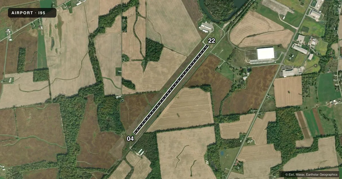
Runways & pattern
Full pagePattern entry · RWY 22
LEFT TRAFFICRunway end performance
| End | TORA | TODA | ASDA | LDA | VGSI | Approach lights | Obstruction |
|---|---|---|---|---|---|---|---|
| 04 | — | — | — | — | — | — | 80', trees, 1697' from thr, 212' R of cntrln, slope 18 |
| 22 | — | — | — | — | — | — | 30', acft, 201' from thr, 220' R of cntrln, slope 0 |
Declared distances in feet. TORA = takeoff run available, TODA = takeoff distance, ASDA = accelerate-stop, LDA = landing distance.
Airport sketch
Runways drawn to scale from FAA survey coordinates, rendered over satellite imagery. Not for navigation.
Approaches & charts
Services on the field
Fuel grades, oxygen, maintenance, ramp storage and lighting — as declared to the FAA by the airport operator.
Fuel & services
- Fuel
- 100LLA1+
- Oxygen (bottled)
- Not available
- Oxygen (bulk)
- Not available
- Airframe repair
- Major
- Power plant repair
- Major
Ramp & ground
- Transient storage
- Tie-down
- Hangar
- Landing fee
- No fee published
- Customs
- Not available
- Lighting schedule
- SEE RMK
- Beacon schedule
- SS-SR
- Beacon
- White / Green (civil land)(WG)
- Wind indicator
- Lighted
- Segmented circle
- No
Fuel & FBOs
Cheapest 100LL and Jet A on the field and nearby. Always confirm with the FBO before taxi.
Airport notes
Surface conditions, obstructions, local procedures, lighting outages and other notes published with each FAA cycle.
General notes
- DEER & BIRDS ON & INVOF ARPT.
- FOR CD CTC COLUMBUS APCH AT 614-338-8537.
Lighting notes
- ACTVT MIRL RWY 04/22 - 3 CLICKS CTAF WI 3 SECS.
Fuel notes
- 100LLFULL SERVE ONLY, AFT HRS CALL 419-673-9542.
- A1+FULL SERVE ONLY, AFT HRS CALL 419-673-9542.
Approach & departure obstructions
- 2230 FT TWY, 0-200 FT DIST, 220-250 FT R.
Other notes
- VFR USE ONLY.
- PRIOR CDN RQRD.
- 1UNATNDD MAJOR HOLS.
VFR map & nearby airports
VFR sectional. Tap any ICAO chip to open that airport.
Key facts · I95
Answer card- ICAO
- I95
- Name
- HARDIN COUNTY
- Location
- KENTON, OHIO
- Elevation
- 1,029 ft MSL
- Traffic pattern altitude
- 2,029 ft MSL (1,000 AGL)
- Control tower
- Non-towered (use CTAF)
- Total runways
- 1
- Longest runway
- 04/22 · 4,797 ft
- Published ILS approaches
- 0
- Published frequencies
- 4
- Magnetic variation
- 6°
- Current flight rules
- VFR
- Current wind
- 230° at 12 kt
- Favored runway now
- RWY 22
Hardin County Airport sits near Kenton, Ohio. The field elevation is 1,029 ft MSL. It has one asphalt runway, 04/22, at 4,797 ft. There is no control tower. The published frequencies include Columbus Approach on 134.45 and 323.15 MHz. CTAF and UNICOM are both 122.8 MHz.
No ILS approaches are published here. The airport is listed for VFR use only. Pattern altitude is not published. Use the standard 1,000 ft AGL pattern unless local procedures or ATC say otherwise. The on-field FBO is Hardin County Airport. It carries 100LL and Jet A. Full service fuel is noted. Call ahead if you need after-hours service. The Chart Supplement also notes that the airport is unattended on major holidays.
A few operational notes matter here. Deer and birds are reported on and near the airport. There is also a 30-foot taxiway obstruction near runway 22, off the right side. Medium intensity runway lights on 04/22 are pilot-controlled with 3 clicks on CTAF within 3 seconds. For clearance delivery, contact Columbus Approach at 614-338-8537. This is a good field to brief carefully before arrival, especially if you are planning a night stop or a first visit.