METAR & TAF KSCA
KSCA does not publish a METAR.
Showing the nearest reporting station: KAXV (NEIL ARMSTRONG) · 16.6 NM away. Conditions at KSCA may differ.
METAR · KAXV
Observed 01:35Z
KAXV 120135Z AUTO 18005KT 10SM CLR 25/22 A2979 RMK AO2
- Wind
- 180° @ 5 kt
- Visibility
- 10 SM
- Temp / Dew
- 25°C / 22°C
- Altimeter
- 29.79 inHg
- Clouds
- CLR
- Density alt
- 2,656 ft
- Ceiling
- Unlimited
- Rules
- VFR
Airport info & contacts
Manager on record, flight service, ARTCC, attendance schedule and pattern altitude — published by the FAA and refreshed every 28 days.
Location
- From city
- 3 NM S
- VFR sectional
- DETROIT
- Pattern altitude
- 800 ft AGL · 1,844 ft MSL
- ARTCC
- ZID · INDIANAPOLIS
- NOTAM facility
- DAY (NOTAM-D)
Airport manager
- Name
- MIKE CHAPPIE
- Phone
- 937-492-9794
- Address
- 14833 SIDNEY-PLATTSVILLE RD, SIDNEY OH 45365-8772
Flight service · Hours
- FSS DAY
- DAYTON1-800-WX-BRIEF
- Attendance
- MON-SAT · 0800-1800
Frequencies
Tap any row to copy the frequency to your clipboard.
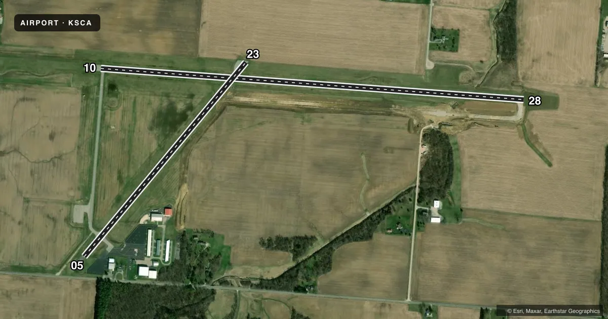
Runways & pattern
Full pagePattern entry · RWY 23
LEFT TRAFFIC| Runway | Heading (°M) | Length | Surface | Traffic |
|---|---|---|---|---|
| 10/28 | 89° / 269° | 5,013 ft | ASPH | Standard L |
| 05/23Favored | 35° / 215° | 2,981 ft | ASPH | Standard L |
Runway end performance
| End | TORA | TODA | ASDA | LDA | VGSI | Approach lights | Obstruction |
|---|---|---|---|---|---|---|---|
| 10 | — | — | — | — | PAPI 2-box left(3°) | — | 7', crops, 201' from thr, 215' R of cntrln, slope 0 |
| 28 | — | — | — | — | PAPI 2-box left(3°) | — | 15', crops, 201' from thr, 110' R of cntrln, slope 0 |
| 23 | — | — | — | — | — | — | 8', crops, 201' from thr, 125' R of cntrln, slope 0 |
Declared distances in feet. TORA = takeoff run available, TODA = takeoff distance, ASDA = accelerate-stop, LDA = landing distance.
Airport sketch
Runways drawn to scale from FAA survey coordinates, rendered over satellite imagery. Not for navigation.
Approaches & charts
Services on the field
Fuel grades, oxygen, maintenance, ramp storage and lighting — as declared to the FAA by the airport operator.
Fuel & services
- Fuel
- 100LLA
- Oxygen (bottled)
- Not available
- Oxygen (bulk)
- High pressure
- Airframe repair
- Major
- Power plant repair
- Major
- Other services
- INSTR,RNTL
Ramp & ground
- Transient storage
- Tie-down
- Hangar
- Customs
- Not available
- Lighting schedule
- SEE RMK
- Beacon schedule
- SS-SR
- Beacon
- White / Green (civil land)(WG)
- Wind indicator
- Lighted
- Segmented circle
- No
Fuel & FBOs
Cheapest 100LL and Jet A on the field and nearby. Always confirm with the FBO before taxi.
Airport notes
Surface conditions, obstructions, local procedures, lighting outages and other notes published with each FAA cycle.
General notes
- FOR CD CTC COLUMBUS APCH AT 614-338-8537.
Lighting notes
- ACTVT REIL RWY 10 & 28; MIRL RWY 10/28 - CTAF. PAPI RWY 10 & 28 OPR CONSLY.
Fuel notes
- 100LL100LL & JET A AVBL H24 VIA CREDIT CARD.
- AANTI-ICING ADDITIVE AVBL AT NOZZLE.
Approach & departure obstructions
- 107 FT CROPS, 0-200 FT DIST, 215 FT L.
- 2815 FT CROPS ON SLP, 0-200 FT DIST, 110 FT L/R.
- 238 FT CROPS AT PAVEMENT END.
- 10FADED EXC RWY NR.
- 28FADED EXC RWY NR.
- 10TRRN/CROPS IN APCH SFC.
Other notes
- PRIOR CDN RQRD FOR TSNT HNGR.
VFR map & nearby airports
VFR sectional. Tap any ICAO chip to open that airport.
Key facts · KSCA
Answer card- ICAO
- KSCA
- Name
- SIDNEY MUNI
- Location
- SIDNEY, OHIO
- Elevation
- 1,044 ft MSL
- Traffic pattern altitude
- 1,844 ft MSL (800 AGL)
- Control tower
- Non-towered (use CTAF)
- Total runways
- 2
- Longest runway
- 10/28 · 5,013 ft
- Published ILS approaches
- 0
- Published frequencies
- 4
- Magnetic variation
- 5°
- Current flight rules
- VFR
- Current wind
- 180° at 5 kt
- Favored runway now
- RWY 23
Sidney Muni sits in Sidney, Ohio. Field elevation is 1,044 ft MSL. The airport has two asphalt runways. The longest is runway 10/28 at 5,013 ft. There is no control tower. Pattern altitude is 800 ft AGL, which is 1,844 ft MSL.
No ILS approaches are published here. For clearance delivery, Columbus Approach is listed in the Chart Supplement. CTAF and UNICOM are both 123.05. Aerotech Aviation is on the field. It carries 100LL and Jet A. 100LL and Jet A are available 24 hours a day by credit card. Anti-icing additive is available at the nozzle.
A first-time pilot should pay attention to the published runway notes. There are crops and terrain near the approach surfaces for runway 10. Runway 10 also has a faded runway number marking. Runway 28 has crops on a slope near the runway edge, plus a faded runway number marking. Runway 23 has 8 foot crops at the pavement end. Runway end identifier lights are on runways 10 and 28. Medium intensity runway lights on 10 and 28 are controlled on CTAF. PAPI is available on both ends and operates continuously. Prior coordination is required for transient hangar. Check the current FAA Chart Supplement for any other local procedures before you go.