METAR & TAF KEDJ
Current METAR
Observed 23:35Z
KEDJ 262335Z AUTO 00000KT 10SM FEW050 26/22 A2993 RMK A01
- Wind
- 000° @ 0 kt
- Visibility
- 10 SM
- Temp / Dew
- 26°C / 22°C
- Altimeter
- 29.93 inHg
- Clouds
- FEW
- Density alt
- 2,698 ft
- Ceiling
- Unlimited
- Rules
- VFR
Airport info & contacts
Manager on record, flight service, ARTCC, attendance schedule and pattern altitude — published by the FAA and refreshed every 28 days.
Location
- From city
- 3 NM W
- VFR sectional
- DETROIT
- ARTCC
- ZID · INDIANAPOLIS
- NOTAM facility
- EDJ (NOTAM-D)
Airport manager
- Name
- STEVE BUCHENROTH
- Phone
- 937-593-8210
- Address
- 3100 STATE ROUTE 47 W, PO BOX 87, BELLEFONTAINE OH 43311-9012
Flight service · Hours
- FSS DAY
- DAYTON1-800-WX-BRIEF
- Attendance
- MON-FRI · 0800-DUSK
- SAT-SUN · 0800-1700
Frequencies
Tap any row to copy the frequency to your clipboard.
Runways & pattern
Full pagePattern entry · RWY 07
LEFT TRAFFICRunway end performance
| End | TORA | TODA | ASDA | LDA | VGSI | Approach lights | Obstruction |
|---|---|---|---|---|---|---|---|
| 07 | — | — | — | — | PAPI 4-box left(3°) | — | — |
| 25 | — | — | — | — | PAPI 4-box left(4°) | — | — |
Declared distances in feet. TORA = takeoff run available, TODA = takeoff distance, ASDA = accelerate-stop, LDA = landing distance.
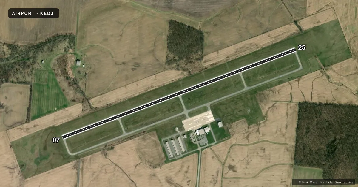
Airport sketch
Runways drawn to scale from FAA survey coordinates, rendered over satellite imagery. Not for navigation.
Approaches & charts
Services on the field
Fuel grades, oxygen, maintenance, ramp storage and lighting — as declared to the FAA by the airport operator.
Fuel & services
- Fuel
- 100LLA1+
- Airframe repair
- Major
- Power plant repair
- Major
- Other services
- INSTR,RNTL
Ramp & ground
- Transient storage
- Tie-down
- Hangar
- Lighting schedule
- SEE RMK
- Beacon schedule
- SS-SR
- Beacon
- White / Green (civil land)(WG)
- Wind indicator
- Lighted
- Segmented circle
- No
Fuel & FBOs
Cheapest 100LL and Jet A on the field and nearby. Always confirm with the FBO before taxi.
Airport notes
Surface conditions, obstructions, local procedures, lighting outages and other notes published with each FAA cycle.
General notes
- FOR CD CTC COLUMBUS APCH AT 614-338-8537.
- OCNL DEER & COYOTES ON & INVOF ARPT.
Lighting notes
- ACTVT REIL RWY 07 & 25; MIRL RWY 07/25 - CTAF. PAPI RWY 07 & 25 OPR CONSLY.
Other notes
- SEE AIRSPACE CASE 02-AGL-0501-NRA.
- PRIOR CDN RQRD.
- MANAGERCELL 937-597-2055.
VFR map & nearby airports
VFR sectional. Tap any ICAO chip to open that airport.
Key facts · KEDJ
Answer card- ICAO
- KEDJ
- Name
- BELLEFONTAINE RGNL
- Location
- BELLEFONTAINE, OHIO
- Elevation
- 1,121.6 ft MSL
- Traffic pattern altitude
- 2,121.6 ft MSL (1,000 AGL)
- Control tower
- Non-towered (use CTAF)
- Total runways
- 1
- Longest runway
- 07/25 · 5,000 ft
- Published ILS approaches
- 0
- Published frequencies
- 4
- Magnetic variation
- 5°
- Current flight rules
- VFR
- Current wind
- 000° at 0 kt
- Favored runway now
- –
Bellefontaine Rgnl is in Bellefontaine, Ohio. The field elevation is 1,121.6 ft MSL. It has one runway, 07/25, which is 5,000 ft long. There is no control tower. Pattern altitude is not published, so use the standard 1,000 ft AGL for light piston traffic unless the current Chart Supplement says otherwise.
No ILS approaches are published here. The airport remarks call out prior coordination required, so plan ahead before you show up. Runway end identifier lights are active on 07 and 25. Medium intensity runway lights are on both ends. They are controlled by CTAF. The PAPI on 07 and 25 operates continuously. That helps for night work. You still need to verify current airport status before departure.
Midwest Corporate Air is on the field. It carries 100LL and Jet A. For clearance delivery, Columbus Approach is listed at 614-338-8537. The airport also notes occasional deer and coyotes in the vicinity, so keep a sharp lookout on taxi, takeoff and landing. This is a non-towered field with published remarks that matter, so brief the arrival carefully and check the current Chart Supplement for any airspace or operating notes tied to case 02-AGL-0501-NRA.