METAR & TAF KMRT
Current METAR
Observed 20:35Z
KMRT 272035Z AUTO 17003KT 10SM CLR 28/23 A2985 RMK AO2 LTG DSNT N
- Wind
- 170° @ 3 kt
- Visibility
- 10 SM
- Temp / Dew
- 28°C / 23°C
- Altimeter
- 29.85 inHg
- Clouds
- CLR
- Density alt
- 2,912 ft
- Ceiling
- Unlimited
- Rules
- VFR
Airport info & contacts
Manager on record, flight service, ARTCC, attendance schedule and pattern altitude — published by the FAA and refreshed every 28 days.
Location
- From city
- 1 NM SE
- VFR sectional
- DETROIT
- ARTCC
- ZID · INDIANAPOLIS
- NOTAM facility
- MRT (NOTAM-D)
Airport manager
- Name
- DAVID HOLDEN
- Phone
- 937-644-2055
- Address
- 760 CLYMER RD, MARYSVILLE OH 43040-9502
Flight service · Hours
- FSS DAY
- DAYTON1-800-WX-BRIEF
- Attendance
- 0800-1700
Frequencies
Tap any row to copy the frequency to your clipboard.
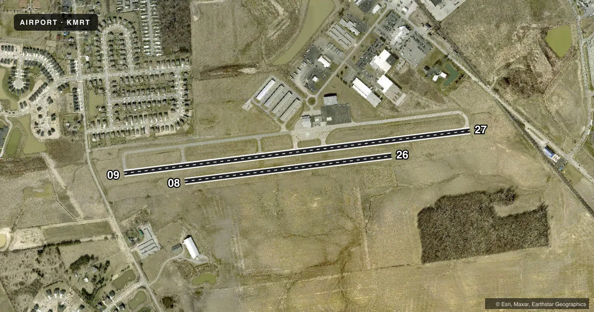
Runways & pattern
Full pagePattern entry · RWY 09
LEFT TRAFFIC| Runway | Heading (°M) | Length | Surface | Traffic |
|---|---|---|---|---|
| 09/27Favored | 78° / 258° | 4,218 ft | ASPH | Standard L |
| 08/26 | 78° / 258° | 2,522 ft | TURF | Standard L |
Runway end performance
| End | TORA | TODA | ASDA | LDA | VGSI | Approach lights | Obstruction |
|---|---|---|---|---|---|---|---|
| 09 | — | — | — | — | PAPI 4-box left(3°) | — | — |
| 27 | — | — | — | — | PAPI 4-box left(3°) | — | 20', rr, 425' from thr, 260' R of cntrln, slope 11 |
Declared distances in feet. TORA = takeoff run available, TODA = takeoff distance, ASDA = accelerate-stop, LDA = landing distance.
Airport sketch
Runways drawn to scale from FAA survey coordinates, rendered over satellite imagery. Not for navigation.
Approaches & charts
Services on the field
Fuel grades, oxygen, maintenance, ramp storage and lighting — as declared to the FAA by the airport operator.
Fuel & services
- Fuel
- 100LLA1A1+
- Oxygen (bottled)
- Not available
- Oxygen (bulk)
- Not available
- Airframe repair
- Major
- Power plant repair
- Major
- Other services
- INSTR,RNTL
Ramp & ground
- Transient storage
- Tie-down
- Hangar
- Landing fee
- No fee published
- Customs
- Not available
- Lighting schedule
- SEE RMK
- Beacon schedule
- SS-SR
- Beacon
- White / Green (civil land)(WG)
- Wind indicator
- Lighted
- Segmented circle
- No
Fuel & FBOs
Cheapest 100LL and Jet A on the field and nearby. Always confirm with the FBO before taxi.
Airport notes
Surface conditions, obstructions, local procedures, lighting outages and other notes published with each FAA cycle.
General notes
- DEER, BIRDS, & OTR WILDLIFE ON & INVOF ARPT.
- FOR CD CTC COLUMBUS APCH AT 614-338-8537.
Lighting notes
- ACTVT REIL RWY 09 & 27; PAPI RWY 09 & 27; MIRL RWY 09/27 - CTAF.
Fuel notes
- 100LLFUEL AVBL H24 SELF SVC VIA CREDIT CARD.
Approach & departure obstructions
- 27CK NOTAMS FOR STS OF AEROBATIC BOX SOUTH OF RWY 09/27 & 08/26 - RP RWY 27 & 26 WHEN ACTV.
- 09CALM WIND RWY.
- 08THR & EDGES MKD WITH CONES.
- 26THR & EDGES MKD WITH CONES.
- 27APCH RATIO 27:1 TO DTHR DUE TO +20 FT RR, 425 FT DIST, 260 FT R.
Other notes
- RAMP FEE FOR COML ACFT.
- PRIOR CDN RQRD.
- MANAGERSKYVISTAAVIATION@GMAIL.COM.
- MANAGERAFT HRS & EMERG 937-741-3120.
VFR map & nearby airports
VFR sectional. Tap any ICAO chip to open that airport.
Key facts · KMRT
Answer card- ICAO
- KMRT
- Name
- UNION COUNTY
- Location
- MARYSVILLE, OHIO
- Elevation
- 1,020.7 ft MSL
- Traffic pattern altitude
- 2,020.7 ft MSL (1,000 AGL)
- Control tower
- Non-towered (use CTAF)
- Total runways
- 2
- Longest runway
- 09/27 · 4,218 ft
- Published ILS approaches
- 0
- Published frequencies
- 4
- Magnetic variation
- 5°
- Current flight rules
- VFR
- Current wind
- 170° at 3 kt
- Favored runway now
- RWY 09
Union County Airport sits in Marysville, Ohio. Field elevation is 1,020.7 ft MSL. It has two runways. The longest is 09/27 at 4,218 ft asphalt. The other runway is 08/26 at 2,522 ft turf. This is an untowered field. CTAF and UNICOM are both 123.05. Columbus Approach is listed for approach and departure work on 125.95 and 317.775. No ILS approaches are published here.
Pattern altitude is not published. Use the current FAA Chart Supplement before flying the pattern. SkyVista Aviation is on the field. It carries 100LL, Jet A and Jet A Prist. 100LL is available 24 hours self-serve by credit card.
There are a few operational notes to keep in mind. Runway 27 has a displaced threshold issue tied to a railroad obstacle on the approach side. The Chart Supplement says to check NOTAMs for the aerobatic box south of the field. Right traffic is recommended for runway 27 and runway 26 when that activity is in play. Runway 26 and runway 08 use cone markings at the threshold and edges. Wildlife is also a factor here, so expect deer and birds on or near the airport. For clearance delivery, Columbus Approach is the contact listed in the remarks.