METAR & TAF KUYF
Current METAR
Observed 17:15Z
KUYF 271715Z AUTO 22003KT 10SM SCT075 SCT090 SCT120 26/21 A2991 RMK AO2
- Wind
- 220° @ 3 kt
- Visibility
- 10 SM
- Temp / Dew
- 26°C / 21°C
- Altimeter
- 29.91 inHg
- Clouds
- SCT
- Density alt
- 2,674 ft
- Ceiling
- Unlimited
- Rules
- VFR
Airport info & contacts
Manager on record, flight service, ARTCC, attendance schedule and pattern altitude — published by the FAA and refreshed every 28 days.
Location
- From city
- 3 NM N
- VFR sectional
- CINCINNATI
- ARTCC
- ZID · INDIANAPOLIS
- NOTAM facility
- UYF (NOTAM-D)
Airport manager
- Name
- JOHN DUHL
- Phone
- 740-852-5040
- Address
- 1281 US HIGHWAY 40 SW, LONDON OH 43140-9213
Flight service · Hours
- FSS DAY
- DAYTON1-800-WX-BRIEF
- Attendance
- MON-FRI · 0800-1600
- SAT-SUN · 0900-1700
Frequencies
Tap any row to copy the frequency to your clipboard.
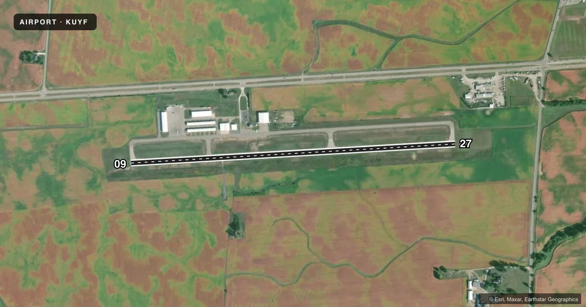
Runways & pattern
Full pagePattern entry · RWY 27
LEFT TRAFFICRunway end performance
| End | TORA | TODA | ASDA | LDA | VGSI | Approach lights | Obstruction |
|---|---|---|---|---|---|---|---|
| 09 | — | — | — | — | PAPI 4-box left(3°) | — | — |
| 27 | — | — | — | — | PAPI 4-box left(3°) | — | 7', tree, 228' from thr, 236' R of cntrln, slope 4 |
Declared distances in feet. TORA = takeoff run available, TODA = takeoff distance, ASDA = accelerate-stop, LDA = landing distance.
Airport sketch
Runways drawn to scale from FAA survey coordinates, rendered over satellite imagery. Not for navigation.
Approaches & charts
Services on the field
Fuel grades, oxygen, maintenance, ramp storage and lighting — as declared to the FAA by the airport operator.
Fuel & services
- Fuel
- 100LLA
- Oxygen (bottled)
- Not available
- Oxygen (bulk)
- Not available
- Airframe repair
- Not available
- Power plant repair
- Not available
Ramp & ground
- Transient storage
- Tie-down
- Hangar
- Landing fee
- No fee published
- Customs
- Not available
- Lighting schedule
- SEE RMK
- Beacon schedule
- SS-SR
- Beacon
- White / Green (civil land)(WG)
- Wind indicator
- Lighted
- Segmented circle
- No
Fuel & FBOs
Cheapest 100LL and Jet A on the field and nearby. Always confirm with the FBO before taxi.
Airport notes
Surface conditions, obstructions, local procedures, lighting outages and other notes published with each FAA cycle.
General notes
- FOR CD CTC COLUMBUS APCH AT 614-338-8537.
Lighting notes
- ACTVT REIL RWY 09 & 27; MIRL RWY 09/27 - CTAF. PAPI RWY 09 & 27 OPR CONSLY.
Fuel notes
- 100LLFUEL AVBL H24 SELF SER.
Approach & departure obstructions
- 27+3-12 FT BRUSH/TREES, 60-200 FT DIST, 175 FT R.
Other notes
- PRIOR CDN RQRD.
VFR map & nearby airports
VFR sectional. Tap any ICAO chip to open that airport.
Key facts · KUYF
Answer card- ICAO
- KUYF
- Name
- MADISON COUNTY
- Location
- LONDON, OHIO
- Elevation
- 1,081.6 ft MSL
- Traffic pattern altitude
- 2,081.6 ft MSL (1,000 AGL)
- Control tower
- Non-towered (use CTAF)
- Total runways
- 1
- Longest runway
- 09/27 · 4,000 ft
- Published ILS approaches
- 0
- Published frequencies
- 4
- Magnetic variation
- 6°
- Current flight rules
- VFR
- Current wind
- 220° at 3 kt
- Favored runway now
- RWY 27
Madison County Airport is in London, Ohio. The field elevation is 1,081.6 ft MSL. It has one runway, 09/27, which is 4,000 ft long and asphalt. There is no control tower. The published pattern altitude is not listed, so use the standard 1,000 ft AGL for light piston traffic unless the current Chart Supplement says otherwise.
No ILS approaches are published here. The airport uses CTAF 123.0 and UNICOM 123.0. Columbus Approach handles APCH and DEP on 134.0 and 279.6. For clearance delivery, contact Columbus Approach at 614-338-8537. Runway end identifier lights are active on 09 and 27. Medium intensity runway lights are on 09 and 27. They are controlled by CTAF. PAPI is available on both ends and operates continuously.
Madison County Airport has one on-field FBO, Madison County Airport. It carries 100LL and Jet A. Fuel is available 24 hours a day self-service. Prior coordination is required. There are also brush and trees 3 to 12 ft high located 60 to 200 ft away, 175 ft right of runway 27. That is worth keeping in mind on rollout and departure. This is a non-towered field. Plan your calls, watch the pattern and verify current procedures before arrival.