METAR & TAF I23
Current METAR
Observed 16:55Z
KI23 271655Z AUTO 00000KT 9SM CLR 28/20 A2991 RMK AO2 PRESFR
- Wind
- 000° @ 0 kt
- Visibility
- 9 SM
- Temp / Dew
- 28°C / 20°C
- Altimeter
- 29.91 inHg
- Clouds
- CLR
- Density alt
- 2,787 ft
- Ceiling
- Unlimited
- Rules
- VFR
Airport info & contacts
Manager on record, flight service, ARTCC, attendance schedule and pattern altitude — published by the FAA and refreshed every 28 days.
Location
- From city
- 2 NM NNE
- VFR sectional
- CINCINNATI
- Pattern altitude
- 800 ft AGL · 1,780 ft MSL
- ARTCC
- ZID · INDIANAPOLIS
- NOTAM facility
- I23 (NOTAM-D)
Airport manager
- Name
- JERRY VAN DYKE
- Phone
- 740-335-2430
- Address
- 2770 STATE ROUTE 38 NE, WASHINGTON COURT HOUSE OH 43160-9006
Flight service · Hours
- FSS DAY
- DAYTON1-800-WX-BRIEF
- Attendance
- MON-SAT · 0800-1800
Frequencies
Tap any row to copy the frequency to your clipboard.
Runways & pattern
Full pagePattern entry · RWY 05
LEFT TRAFFICRunway end performance
| End | TORA | TODA | ASDA | LDA | VGSI | Approach lights | Obstruction |
|---|---|---|---|---|---|---|---|
| 23 | — | — | — | — | PAPI 4-box left(3°) | — | 28', rr, 200' from thr, 240' R of cntrln, slope 0 |
Declared distances in feet. TORA = takeoff run available, TODA = takeoff distance, ASDA = accelerate-stop, LDA = landing distance.
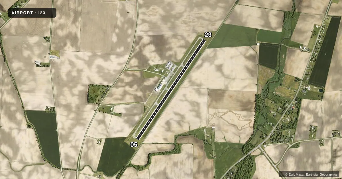
Airport sketch
Runways drawn to scale from FAA survey coordinates, rendered over satellite imagery. Not for navigation.
Approaches & charts
Services on the field
Fuel grades, oxygen, maintenance, ramp storage and lighting — as declared to the FAA by the airport operator.
Fuel & services
- Fuel
- 100LLA
- Oxygen (bottled)
- Not available
- Oxygen (bulk)
- Not available
- Airframe repair
- Major
- Power plant repair
- Major
- Other services
- INSTR,RNTL
Ramp & ground
- Transient storage
- Tie-down
- Hangar
- Landing fee
- No fee published
- Customs
- Not available
- Lighting schedule
- SEE RMK
- Beacon schedule
- SS-SR
- Beacon
- White / Green (civil land)(WG)
- Wind indicator
- Lighted
- Segmented circle
- No
Fuel & FBOs
Cheapest 100LL and Jet A on the field and nearby. Always confirm with the FBO before taxi.
Airport notes
Surface conditions, obstructions, local procedures, lighting outages and other notes published with each FAA cycle.
General notes
- FOR CD CTC COLUMBUS APCH AT 614-338-8537.
- BIRDS INVOF ARPT.
Lighting notes
- ACTVT REIL RWY 23; MIRL RWY 05/23 - CTAF. PAPI RWY 23 OPR CONSLY.
Fuel notes
- 100LL100LL & JET A AVBL FULL SVC ON REQ DRG BUS HRS; H24 SELF SVC VIA CREDIT CARD.
Approach & departure obstructions
- 23+28 FT RLRD, 0-200 FT DIST, 240 FT L.
- 23OBSTN CLNC SLP 0:1 DUE TO +28 FT RLRD, 200 FT DIST, 240 FT L.
Other notes
- PRIOR CDN RQRD.
- ROPES AVBL ON REQ.
- MANAGERCELL 937-403-7170.
VFR map & nearby airports
VFR sectional. Tap any ICAO chip to open that airport.
Key facts · I23
Answer card- ICAO
- I23
- Name
- FAYETTE COUNTY
- Location
- WASHINGTON COURT HOUSE, OHIO
- Elevation
- 979.7 ft MSL
- Traffic pattern altitude
- 1,779.7 ft MSL (800 AGL)
- Control tower
- Non-towered (use CTAF)
- Total runways
- 1
- Longest runway
- 05/23 · 5,097 ft
- Published ILS approaches
- 0
- Published frequencies
- 4
- Magnetic variation
- 6°
- Current flight rules
- VFR
- Current wind
- 000° at 0 kt
- Favored runway now
- –
Fayette County Airport sits in Washington Court House, Ohio. The field elevation is 979.7 ft MSL. It has one runway, 05/23, at 5,097 ft. There is no control tower. Pattern altitude is 800 ft AGL, which is 1,779.7 ft MSL.
No ILS approaches are published here. The airport uses CTAF 122.8 and UNICOM 122.8. Columbus Approach handles the listed approach and departure frequencies. For clearance delivery, contact Columbus Approach directly. The runway lighting setup is useful to know before arrival. Runway 23 has REIL lighting. Medium intensity runway lighting is available on 05 and 23. The PAPI on 23 operates continuously.
Fayette County Airport is on the field and carries 100LL and Jet A with Prist. Full service is available on request during business hours. Self-serve fuel is available 24 hours by credit card. The published remarks also note birds in the vicinity. There is a railroad near the runway 23 threshold, so pay close attention on short final. Prior coordination is required. If you are planning a first visit, call ahead and verify current field conditions with the airport operator or the FBO directly by phone.