METAR & TAF KVES
Current METAR
Observed 12:55Z
KVES 121255Z AUTO 28007KT 10SM BKN014 BKN021 BKN026 22/22 A2992 RMK AO2
- Wind
- 280° @ 7 kt
- Visibility
- 10 SM
- Temp / Dew
- 22°C / 22°C
- Altimeter
- 29.92 inHg
- Clouds
- BKN
- Density alt
- 2,089 ft
- Ceiling
- 1,400 ft AGL
- Rules
- MVFR
Airport info & contacts
Manager on record, flight service, ARTCC, attendance schedule and pattern altitude — published by the FAA and refreshed every 28 days.
Location
- From city
- 2 NM SW
- VFR sectional
- DETROIT
- ARTCC
- ZID · INDIANAPOLIS
- NOTAM facility
- VES (NOTAM-D)
Airport manager
- Name
- SCOTT NAAS
- Phone
- 937-467-9360
- Address
- 9724 STATE ROUTE 121, VERSAILLES OH 45380-9513
Flight service · Hours
- FSS DAY
- DAYTON1-800-WX-BRIEF
- Attendance
- MON-FRI · 0800-1630
Frequencies
Tap any row to copy the frequency to your clipboard.
Runways & pattern
Full pagePattern entry · RWY 27
LEFT TRAFFICRunway end performance
| End | TORA | TODA | ASDA | LDA | VGSI | Approach lights | Obstruction |
|---|---|---|---|---|---|---|---|
| 09 | — | — | — | — | PAPI 2-box left(3°) | — | — |
| 27 | — | — | — | — | PAPI 2-box left(3°) | — | — |
Declared distances in feet. TORA = takeoff run available, TODA = takeoff distance, ASDA = accelerate-stop, LDA = landing distance.
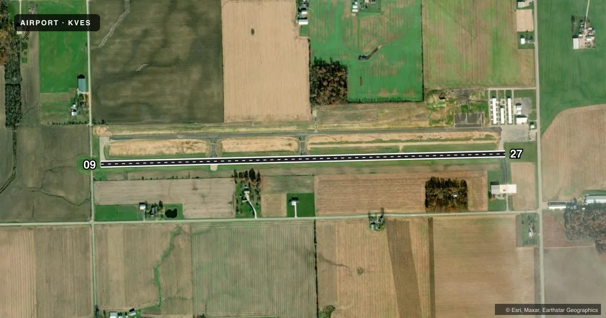
Airport sketch
Runways drawn to scale from FAA survey coordinates, rendered over satellite imagery. Not for navigation.
Approaches & charts
Services on the field
Fuel grades, oxygen, maintenance, ramp storage and lighting — as declared to the FAA by the airport operator.
Fuel & services
- Fuel
- 100LLA+
- Oxygen (bottled)
- Not available
- Oxygen (bulk)
- Not available
- Airframe repair
- Not available
- Power plant repair
- Not available
- Other services
- AMB
Ramp & ground
- Transient storage
- Tie-down
- Hangar
- Landing fee
- No fee published
- Customs
- Not available
- Lighting schedule
- SEE RMK
- Beacon schedule
- SS-SR
- Beacon
- White / Green (civil land)(WG)
- Wind indicator
- Lighted
- Segmented circle
- No
Fuel & FBOs
Cheapest 100LL and Jet A on the field and nearby. Always confirm with the FBO before taxi.
Airport notes
Surface conditions, obstructions, local procedures, lighting outages and other notes published with each FAA cycle.
General notes
- OCNL DEER, BIRDS, & OTR WILDLIFE ON & INVOF ARPT.
- FOR CD CTC COLUMBUS APCH AT 614-338-8537.
Lighting notes
- ACTVT REIL RWY 09 & 27; MIRL RWY 09/27 - CTAF. PAPI RWY 09 & 27 OPR CONSLY.
Fuel notes
- 100LLFUEL LCTD AT EAST RAMP AVBL H24 VIA CREDIT CARD.
Other notes
- PRIOR CDN RQRD.
- MANAGERSNAAS@CO.DARKE.OH.US.
VFR map & nearby airports
VFR sectional. Tap any ICAO chip to open that airport.
Key facts · KVES
Answer card- ICAO
- KVES
- Name
- DARKE COUNTY
- Location
- VERSAILLES, OHIO
- Elevation
- 1,007 ft MSL
- Traffic pattern altitude
- 2,007 ft MSL (1,000 AGL)
- Control tower
- Non-towered (use CTAF)
- Total runways
- 1
- Longest runway
- 09/27 · 4,802 ft
- Published ILS approaches
- 0
- Published frequencies
- 4
- Magnetic variation
- 4°
- Current flight rules
- MVFR
- Current wind
- 280° at 7 kt
- Favored runway now
- RWY 27
Darke County Airport sits near Versailles, Ohio. Field elevation is 1,007 ft MSL. The airport has one runway. Runway 09/27 is 4,802 ft long with asphalt pavement. There is no control tower. No ILS approaches are published, so plan with current weather and the latest instrument data before you go.
The pattern altitude is not published. Use the standard 1,000 ft AGL pattern unless local procedures or current chart data say otherwise. The airport sits in the Columbus approach area, so get your clearance and arrival planning sorted before departure. Published remarks say prior coordination is required. Clearance delivery is handled through Columbus Approach at 614-338-8537.
On the field, Darke County Airport provides AVGAS 100LL and Jet A Prist. Fuel is located on the east ramp. 100LL is available 24 hours by credit card. Runway 09 and 27 have runway end identifier lights. Medium intensity runway lights are activated on the CTAF. PAPI is available on both ends and operates continuously. Watch for deer, birds and other wildlife in the area. That matters here, especially on departure and on short final.