METAR & TAF I22
I22 does not publish a METAR.
Showing the nearest reporting station: KPLD (PORTLAND MUNI) · 17.3 NM away. Conditions at I22 may differ.
METAR · KPLD
Observed 08:15Z
KPLD 270815Z AUTO 00000KT 10SM CLR 21/16 A2989 RMK AO2 T02130163
- Wind
- 000° @ 0 kt
- Visibility
- 10 SM
- Temp / Dew
- 21°C / 16°C
- Altimeter
- 29.89 inHg
- Clouds
- CLR
- Density alt
- 2,149 ft
- Ceiling
- Unlimited
- Rules
- VFR
Airport info & contacts
Manager on record, flight service, ARTCC, attendance schedule and pattern altitude — published by the FAA and refreshed every 28 days.
Location
- From city
- 3 NM E
- VFR sectional
- DETROIT
- Pattern altitude
- 800 ft AGL · 1,923 ft MSL
- ARTCC
- ZID · INDIANAPOLIS
- NOTAM facility
- HUF (NOTAM-D)
Airport manager
- Name
- ERIC LIVINGSTON
- Phone
- 765-584-3611
- Address
- 2937 E STATE RD 32, WINCHESTER IN 47394
Flight service · Hours
- FSS HUF
- TERRE HAUTE1-800-WX-BRIEF
- Attendance
- MON-SAT · 0800-1700
- SUN · 1300-1700
Frequencies
Tap any row to copy the frequency to your clipboard.
Runways & pattern
Full pagePattern entry · RWY 08
LEFT TRAFFICRunway end performance
| End | TORA | TODA | ASDA | LDA | VGSI | Approach lights | Obstruction |
|---|---|---|---|---|---|---|---|
| 08 | — | — | — | — | PAPI 2-box left(3°) | — | 17', crops, 780' from thr, 210' R of cntrln, slope 34 |
| 26 | — | — | — | — | PAPI 2-box left(3°) | — | 13', road, 650' from thr, 0' R of cntrln, slope 34 |
Declared distances in feet. TORA = takeoff run available, TODA = takeoff distance, ASDA = accelerate-stop, LDA = landing distance.
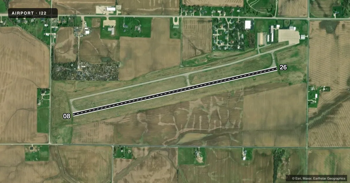
Airport sketch
Runways drawn to scale from FAA survey coordinates, rendered over satellite imagery. Not for navigation.
Approaches & charts
Services on the field
Fuel grades, oxygen, maintenance, ramp storage and lighting — as declared to the FAA by the airport operator.
Fuel & services
- Fuel
- 100LLA
- Oxygen (bottled)
- Not available
- Oxygen (bulk)
- Not available
- Airframe repair
- Minor
- Power plant repair
- Minor
- Other services
- INSTR,RNTL
Ramp & ground
- Transient storage
- Tie-down
- Hangar
- Landing fee
- No fee published
- Customs
- Not available
- Lighting schedule
- SEE RMK
- Beacon schedule
- SS-SR
- Beacon
- White / Green (civil land)(WG)
- Wind indicator
- Lighted
- Segmented circle
- No
Fuel & FBOs
Cheapest 100LL and Jet A on the field and nearby. Always confirm with the FBO before taxi.
Airport notes
Surface conditions, obstructions, local procedures, lighting outages and other notes published with each FAA cycle.
General notes
- COLUMBUS APCH CD (614) 338-8537.
Lighting notes
- ACTVT MIRL RY 08/26; REIL RY 08/26; PAPI RY 08/26 - CTAF.
Other notes
- EXISTED PRIOR TO 1959.
- 1ARPT CLSD THANKSGIVING & CHRISTMAS DAY.
VFR map & nearby airports
VFR sectional. Tap any ICAO chip to open that airport.
Key facts · I22
Answer card- ICAO
- I22
- Name
- RANDOLPH COUNTY
- Location
- WINCHESTER, INDIANA
- Elevation
- 1,122.8 ft MSL
- Traffic pattern altitude
- 1,922.8 ft MSL (800 AGL)
- Control tower
- Non-towered (use CTAF)
- Total runways
- 1
- Longest runway
- 08/26 · 4,300 ft
- Published ILS approaches
- 0
- Published frequencies
- 4
- Magnetic variation
- 5°
- Current flight rules
- VFR
- Current wind
- 000° at 0 kt
- Favored runway now
- –
Randolph County Airport sits in Winchester, Indiana. The field elevation is 1,122.8 ft MSL. It has one runway, 08/26, which is 4,300 ft long. The airport is non-towered. Pattern altitude is 800 ft AGL, which is 1,922.8 ft MSL.
There are no ILS approaches published here. Runway 08/26 has medium intensity lights, runway end identifier lights and PAPI. The PAPI operates on the common traffic advisory frequency. The airport is closed on Thanksgiving and Christmas Day. Columbus Approach handles the published approach and departure frequencies. Contact Columbus Approach clearance delivery at 614-338-8537 if you need that coordination.
On the field, Randolph County Airport carries AVGAS 100LL and Jet A. For a first visit, plan for a rural Indiana airport with a single runway and no tower. Use the current FAA Chart Supplement for any updated procedures or restrictions before you go. The airport has been there since before 1959, so expect a field that serves local traffic and regular general aviation use.