METAR & TAF I61
I61 does not publish a METAR.
Showing the nearest reporting station: KUWL (NEW CASTLE HENRY COUNTY MARLATT FLD) · 7.5 NM away. Conditions at I61 may differ.
METAR · KUWL
Observed 16:15Z
KUWL 271615Z AUTO 00000KT 10SM SCT016 28/24 A2991 RMK A01
- Wind
- 000° @ 0 kt
- Visibility
- 10 SM
- Temp / Dew
- 28°C / 24°C
- Altimeter
- 29.91 inHg
- Clouds
- SCT
- Density alt
- 2,812 ft
- Ceiling
- Unlimited
- Rules
- VFR
Airport info & contacts
Manager on record, flight service, ARTCC, attendance schedule and pattern altitude — published by the FAA and refreshed every 28 days.
Location
- From city
- 1 NM S
- VFR sectional
- ST LOUIS
- ARTCC
- ZID · INDIANAPOLIS
- NOTAM facility
- HUF (NOTAM-D)
Airport manager
- Name
- MIKE HABZANSKY
- Phone
- 765-520-7032
- Address
- 49 E COLLEGE ST, HAGERSTOWN IN 47346
Flight service · Hours
- FSS HUF
- TERRE HAUTE1-800-WX-BRIEF
- Attendance
- Unattended
Frequencies
Tap any row to copy the frequency to your clipboard.
Runways & pattern
Full pagePattern entry · RWY 02
LEFT TRAFFICRunway end performance
| End | TORA | TODA | ASDA | LDA | VGSI | Approach lights | Obstruction |
|---|---|---|---|---|---|---|---|
| 02 | — | — | — | — | — | — | 50', trees, 350' from thr, 160' R of cntrln, slope 7 |
| 20 | — | — | — | — | — | — | 80', trees, 180' from thr, 90' R of cntrln, slope 2 |
Declared distances in feet. TORA = takeoff run available, TODA = takeoff distance, ASDA = accelerate-stop, LDA = landing distance.
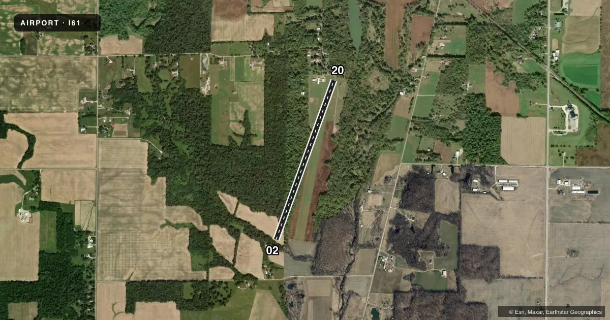
Airport sketch
Runways drawn to scale from FAA survey coordinates, rendered over satellite imagery. Not for navigation.
Approaches & charts
Services on the field
Fuel grades, oxygen, maintenance, ramp storage and lighting — as declared to the FAA by the airport operator.
Fuel & services
- Fuel
- Not available
- Oxygen (bottled)
- Not available
- Oxygen (bulk)
- Not available
- Airframe repair
- Not available
- Power plant repair
- Not available
Ramp & ground
- Transient storage
- Tie-down
- Landing fee
- No fee published
- Lighting schedule
- SEE RMK
- Wind indicator
- Lighted
- Segmented circle
- No
Fuel & FBOs
Cheapest 100LL and Jet A on the field and nearby. Always confirm with the FBO before taxi.
Airport notes
Surface conditions, obstructions, local procedures, lighting outages and other notes published with each FAA cycle.
General notes
- FOR CD CTC COLUMBUS APCH AT 614-338-8537
Lighting notes
- ACTVT LIRL RWY 02/20 - CTAF.
Approach & departure obstructions
- 02DTHR MKD BY LGTS & YELLOW TIRES.
- 20DTHR MKD BY LGTS & YELLOW TIRES.
- 02APCH SLOPE 20:1 FM DTHR; 75 FT TREES 1645 FT FM DTHR.
- 20APCH SLOPE 21:1 FM DTHR; 30 FT TREES 640 FT FM DTHR.
- 20+55 FT TREES 80 FT FM RWY END ON CNTRLN.
Other notes
- EXISTED PRIOR TO 1959.
VFR map & nearby airports
VFR sectional. Tap any ICAO chip to open that airport.
Key facts · I61
Answer card- ICAO
- I61
- Name
- HAGERSTOWN
- Location
- HAGERSTOWN, INDIANA
- Elevation
- 1,000 ft MSL
- Traffic pattern altitude
- 2,000 ft MSL (1,000 AGL)
- Control tower
- Non-towered (use CTAF)
- Total runways
- 1
- Longest runway
- 02/20 · 4,000 ft
- Published ILS approaches
- 0
- Published frequencies
- 2
- Magnetic variation
- 3°
- Current flight rules
- VFR
- Current wind
- 000° at 0 kt
- Favored runway now
- –
Hagerstown Airport sits in Hagerstown, Indiana. Field elevation is 1,000 ft MSL. The airport has one runway. Runway 02/20 is 4,000 ft of turf, which makes the field straightforward on paper but worth a close look before you go. No control tower is published. CTAF and UNICOM are both 123.0. No ILS approaches are published.
Pattern altitude is not published. Use the standard 1,000 ft AGL pattern for light piston traffic unless the current Chart Supplement says otherwise. The runway is lit with low intensity runway lights. They are activated by CTAF.
There are no on-field FBOs listed, so plan on self-sufficiency and verify services with the airport operator or the FBO directly by phone before arrival. Published remarks also note displaced thresholds marked by lights and yellow tires. That matters here because there are tree obstructions near both ends. The runway 20 side has 55 ft trees 80 ft from the runway end on centerline. The runway 02 side has 75 ft trees 1,645 ft from the displaced threshold. Clearance delivery is handled through Columbus Approach at 614-338-8537.
This is a small non-towered field with terrain and obstruction awareness more important than fancy avionics. Check the current Chart Supplement for any published noise or curfew restrictions before flying into the field.