METAR & TAF KUWL
Current METAR
Observed 13:35Z
KUWL 271335Z AUTO 00000KT 4SM BR OVC004 24/24 A2994 RMK A01
- Wind
- 000° @ 0 kt
- Visibility
- 4 SM
- Temp / Dew
- 24°C / 24°C
- Altimeter
- 29.94 inHg
- Clouds
- OVC
- Density alt
- 2,407 ft
- Ceiling
- 400 ft AGL
- Rules
- LIFR
Airport info & contacts
Manager on record, flight service, ARTCC, attendance schedule and pattern altitude — published by the FAA and refreshed every 28 days.
Location
- From city
- 4 NM SE
- VFR sectional
- ST LOUIS
- ARTCC
- ZID · INDIANAPOLIS
- NOTAM facility
- HUF (NOTAM-D)
Airport manager
- Name
- JOHN MARLATT
- Phone
- 765-529-7903
- Address
- 2912 E CO. RD 400 S, NEW CASTLE IN 47362
Flight service · Hours
- FSS HUF
- TERRE HAUTE1-800-WX-BRIEF
- Attendance
- 0800-1800
Frequencies
Tap any row to copy the frequency to your clipboard.
Runways & pattern
Full pagePattern entry · RWY 10
LEFT TRAFFICRunway end performance
| End | TORA | TODA | ASDA | LDA | VGSI | Approach lights | Obstruction |
|---|---|---|---|---|---|---|---|
| 10 | — | — | — | — | PAPI 2-box left(3°) | — | 10', crops, 340' from thr, 0' R of cntrln, slope 14 |
| 28 | — | — | — | — | PAPI 2-box left(3°) | — | 10', crops, 210' from thr, 0' R of cntrln, slope 1 |
Declared distances in feet. TORA = takeoff run available, TODA = takeoff distance, ASDA = accelerate-stop, LDA = landing distance.
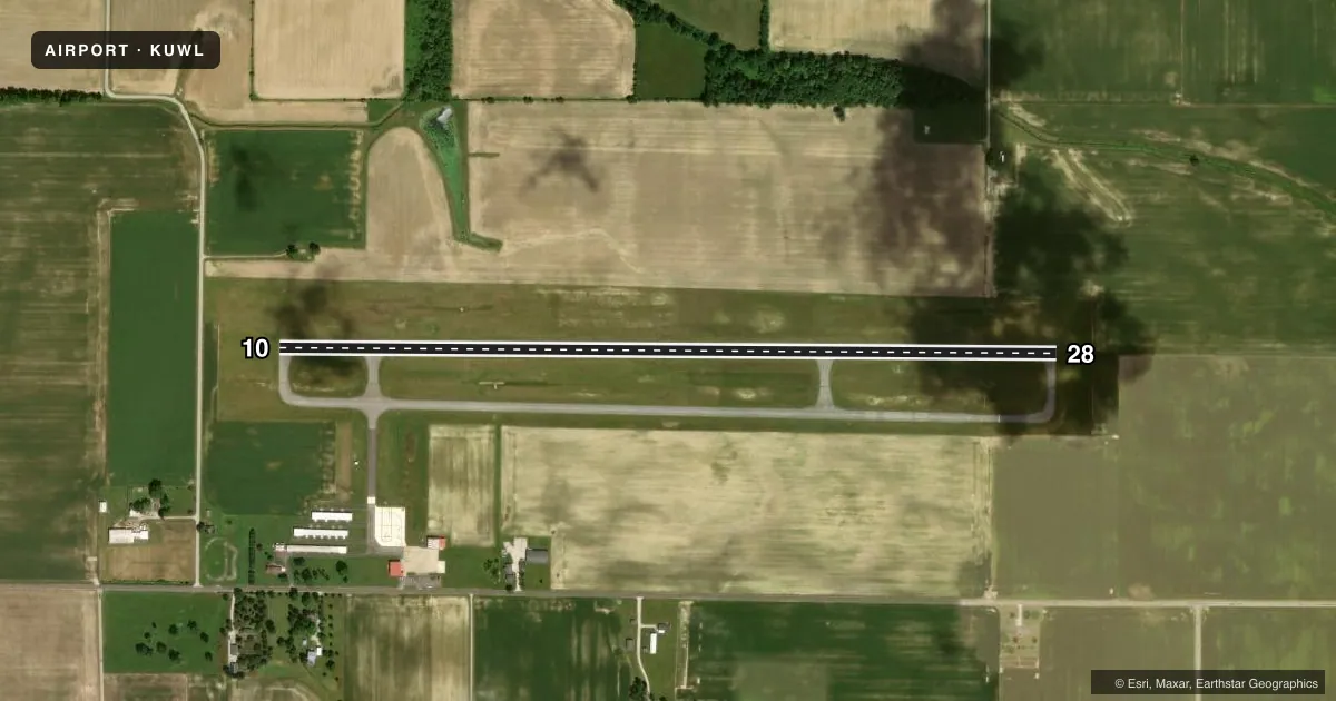
Airport sketch
Runways drawn to scale from FAA survey coordinates, rendered over satellite imagery. Not for navigation.
Approaches & charts
Services on the field
Fuel grades, oxygen, maintenance, ramp storage and lighting — as declared to the FAA by the airport operator.
Fuel & services
- Fuel
- 100LLA
- Airframe repair
- Minor
- Power plant repair
- Minor
- Other services
- AFRT,AMB,CARGO,CHTR,INSTR,RNTL
Ramp & ground
- Transient storage
- Tie-down
- Hangar
- Landing fee
- No fee published
- Customs
- Not available
- Lighting schedule
- SEE RMK
- Beacon schedule
- SS-SR
- Beacon
- White / Green (civil land)(WG)
- Wind indicator
- Lighted
- Segmented circle
- No
Fuel & FBOs
Cheapest 100LL and Jet A on the field and nearby. Always confirm with the FBO before taxi.
Airport notes
Surface conditions, obstructions, local procedures, lighting outages and other notes published with each FAA cycle.
General notes
- FOR CD CTC INDIANAPOLIS APCH AT 317-227-5743.
Lighting notes
- ACTVT REIL RWY 10 & 28; PAPI RWY 10 & 28; MIRL RWY 10/28 - CTAF. MIRL RWY 10/28 PRESET LOW INTST; INCR INTST - CTAF.
Other notes
- ESTAB PRIOR TO 1959.
- 1FUEL AFT HR - 765-332-2969.
- MANAGER765-529-7909.
VFR map & nearby airports
VFR sectional. Tap any ICAO chip to open that airport.
Key facts · KUWL
Answer card- ICAO
- KUWL
- Name
- NEW CASTLE HENRY COUNTY MARLATT FLD
- Location
- NEW CASTLE, INDIANA
- Elevation
- 1,090.2 ft MSL
- Traffic pattern altitude
- 2,090.2 ft MSL (1,000 AGL)
- Control tower
- Non-towered (use CTAF)
- Total runways
- 1
- Longest runway
- 10/28 · 4,201 ft
- Published ILS approaches
- 0
- Published frequencies
- 4
- Magnetic variation
- 6°
- Current flight rules
- LIFR
- Current wind
- 000° at 0 kt
- Favored runway now
- –
New Castle Henry County Marlatt Fld is in New Castle, Indiana. The field elevation is 1,090.2 ft MSL. KUWL has one runway, 10/28, which is 4,201 ft long and asphalt. There is no control tower. Pattern altitude is not published, so use the standard 1,000 ft AGL for light piston traffic unless the current Chart Supplement says otherwise.
No ILS approaches are published here. For IFR work, clearance delivery is handled through Indianapolis Approach. CTAF and UNICOM are both 123.05. The airport uses medium intensity runway lights on 10/28. They are controlled by CTAF. The runway end identifier lights and PAPI are installed on both ends. The runway lights are preset to low intensity. Ask for more intensity on CTAF if needed.
Sky Castle Aviation is the on-field FBO. It carries 100LL and Jet A. After-hours fuel is available by phone. The airport manager’s number is also published for coordination. This is a non-towered field, so expect self-announce traffic and pay close attention to the pattern. If you are new to the airport, verify current runway lighting use, traffic flow and any local procedures with the current FAA Chart Supplement or the airport operator before you go.