METAR & TAF KCEV
KCEV does not publish a METAR.
Showing the nearest reporting station: KRID (RICHMOND MUNI) · 13.8 NM away. Conditions at KCEV may differ.
METAR · KRID
Observed 16:15Z
KRID 271615Z AUTO 00000KT 10SM CLR 26/22 A2994 RMK AO2
- Wind
- 000° @ 0 kt
- Visibility
- 10 SM
- Temp / Dew
- 26°C / 22°C
- Altimeter
- 29.94 inHg
- Clouds
- CLR
- Density alt
- 2,369 ft
- Ceiling
- Unlimited
- Rules
- VFR
Airport info & contacts
Manager on record, flight service, ARTCC, attendance schedule and pattern altitude — published by the FAA and refreshed every 28 days.
Location
- From city
- 3 NM N
- VFR sectional
- ST LOUIS
- ARTCC
- ZID · INDIANAPOLIS
- NOTAM facility
- HUF (NOTAM-D)
Airport manager
- Name
- JEFF DUNGAN
- Phone
- (765) 825-5581
- Address
- 500 AIRPORT DRIVE, CONNERSVILLE IN 47331
Flight service · Hours
- FSS HUF
- TERRE HAUTE1-800-WX-BRIEF
- Attendance
- 0800-1700
Frequencies
Tap any row to copy the frequency to your clipboard.
Runways & pattern
Full pagePattern entry · RWY 18
LEFT TRAFFIC| Runway | Heading (°M) | Length | Surface | Traffic |
|---|---|---|---|---|
| 18/36 | 176° / 356° | 6,503 ft | ASPH | Standard L |
| 04/22 | 32° / 212° | 2,601 ft | TURF | Standard L |
Runway end performance
| End | TORA | TODA | ASDA | LDA | VGSI | Approach lights | Obstruction |
|---|---|---|---|---|---|---|---|
| 18 | — | — | — | — | PAPI 4-box left(3°) | MALSR | 15', road, 340' from thr, 350' R of cntrln, slope 9 |
| 36 | — | — | — | — | PAPI 4-box left(3°) | — | 58', trees, 1620' from thr, 0' R of cntrln, slope 24 |
| 04 | — | — | — | — | — | — | 32', pole, 300' from thr, 175' R of cntrln, slope 9 |
| 22 | — | — | — | — | — | — | 48', trees, 350' from thr, 115' R of cntrln, slope 7 |
Declared distances in feet. TORA = takeoff run available, TODA = takeoff distance, ASDA = accelerate-stop, LDA = landing distance.
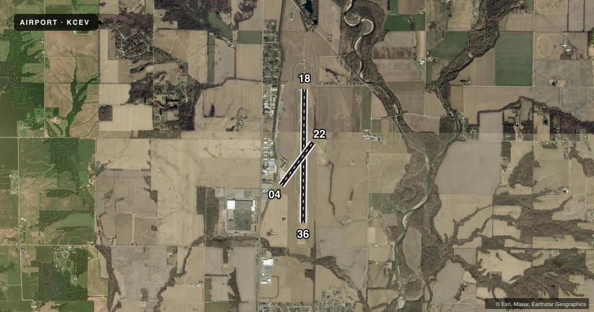
Airport sketch
Runways drawn to scale from FAA survey coordinates, rendered over satellite imagery. Not for navigation.
Approaches & charts
ILS · 1
Services on the field
Fuel grades, oxygen, maintenance, ramp storage and lighting — as declared to the FAA by the airport operator.
Fuel & services
- Fuel
- 100LLA
- Oxygen (bottled)
- Not available
- Oxygen (bulk)
- Not available
- Other services
- AGRI,INSTR
Ramp & ground
- Transient storage
- Tie-down
- Hangar
- Landing fee
- No fee published
- Customs
- Not available
- Lighting schedule
- SEE RMK
- Beacon schedule
- SS-SR
- Beacon
- White / Green (civil land)(WG)
- Wind indicator
- Lighted
- Segmented circle
- No
Fuel & FBOs
Cheapest 100LL and Jet A on the field and nearby. Always confirm with the FBO before taxi.
Airport notes
Surface conditions, obstructions, local procedures, lighting outages and other notes published with each FAA cycle.
General notes
- BIRDS & DEER ON & INVOF ARPT.
- COLUMBUS APCH CD (614) 338-8537.
Lighting notes
- MIRL RWY 18/36 PRESET TO LOW INTST; TO INCR INTST AND ACTVT MALSR RWY 18; REIL RWY 36; MIRL RWY 18/36 - CTAF.
Fuel notes
- 100LLSELF SVC H24.
Approach & departure obstructions
- 18CROPS 220 FT R OF CNTRLN.
- 36CROPS 275 FT L/R OF CNTRLN.
Other notes
- 1AFT HR SVC - 765-969-2586.
VFR map & nearby airports
VFR sectional. Tap any ICAO chip to open that airport.
Key facts · KCEV
Answer card- ICAO
- KCEV
- Name
- METTEL FLD
- Location
- CONNERSVILLE, INDIANA
- Elevation
- 866.3 ft MSL
- Traffic pattern altitude
- 1,866.3 ft MSL (1,000 AGL)
- Control tower
- Non-towered (use CTAF)
- Total runways
- 2
- Longest runway
- 18/36 · 6,503 ft
- Published ILS approaches
- 1
- Published frequencies
- 4
- Magnetic variation
- 4°
- Current flight rules
- VFR
- Current wind
- 000° at 0 kt
- Favored runway now
- –
Mettel Fld sits in Connersville, Indiana. Field elevation is 866.3 ft MSL. The airport has two runways. The longest is runway 18/36 at 6,503 ft. Runway 04/22 is turf and 2,601 ft. There is no control tower. The field has one ILS approach for runway 18. Pattern altitude is not published. Use the standard 1,000 ft AGL for light piston traffic unless the current FAA Chart Supplement says otherwise.
The on-field FBO is Mettel Field. It carries AVGAS 100LL and Jet A. Self-serve 100LL is available 24 hours a day. Published remarks also note that runway 18/36 lighting is controlled by CTAF. The medium intensity lights start at low intensity. Use CTAF to increase intensity. Runway 18 also has a medium intensity approach lighting system with runway alignment indicator lights. Runway end identifier lights are on runway 36.
Watch for birds and deer in the airport area. That matters here. The airport is not towered, so plan your radio work carefully. Columbus Approach handles the published approach and departure frequencies. If you need after-hours service, call the number in the Chart Supplement or contact the FBO directly before you go.