METAR & TAF KOXD
Current METAR
Observed 05:35Z
KOXD 270535Z AUTO 00000KT 7SM CLR 20/20 A2995 RMK AO2 T01970198
- Wind
- 000° @ 0 kt
- Visibility
- 7 SM
- Temp / Dew
- 20°C / 20°C
- Altimeter
- 29.95 inHg
- Clouds
- CLR
- Density alt
- 1,853 ft
- Ceiling
- Unlimited
- Rules
- VFR
Airport info & contacts
Manager on record, flight service, ARTCC, attendance schedule and pattern altitude — published by the FAA and refreshed every 28 days.
Location
- From city
- 2 NM W
- VFR sectional
- CINCINNATI
- ARTCC
- ZID · INDIANAPOLIS
- NOTAM facility
- OXD (NOTAM-D)
Airport manager
- Name
- SCOTT SMITH
- Phone
- 513-330-1502
- Address
- 7101 FAIRFIELD RD, OXFORD OH 45056-9776
Flight service · Hours
- FSS DAY
- DAYTON1-800-WX-BRIEF
- Attendance
- Unattended
Frequencies
Tap any row to copy the frequency to your clipboard.
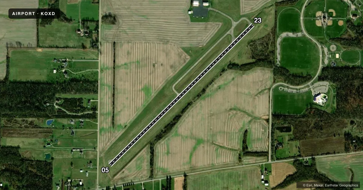
Runways & pattern
Full pagePattern entry · RWY 05
LEFT TRAFFICRunway end performance
| End | TORA | TODA | ASDA | LDA | VGSI | Approach lights | Obstruction |
|---|---|---|---|---|---|---|---|
| 05 | — | — | — | — | PAPI 2-box left(3°) | — | 10', road, 201' from thr, 130' R of cntrln, slope 1 |
| 23 | — | — | — | — | PAPI 2-box left(3°) | — | 12', trees, 361' from thr, 254' R of cntrln, slope 13 |
Declared distances in feet. TORA = takeoff run available, TODA = takeoff distance, ASDA = accelerate-stop, LDA = landing distance.
Airport sketch
Runways drawn to scale from FAA survey coordinates, rendered over satellite imagery. Not for navigation.
Approaches & charts
Services on the field
Fuel grades, oxygen, maintenance, ramp storage and lighting — as declared to the FAA by the airport operator.
Fuel & services
- Fuel
- 100LLA1+
- Oxygen (bottled)
- Not available
- Oxygen (bulk)
- Not available
- Airframe repair
- Minor
- Power plant repair
- Minor
- Other services
- INSTR,RNTL
Ramp & ground
- Transient storage
- Tie-down
- Hangar
- Landing fee
- No fee published
- Customs
- Not available
- Lighting schedule
- SEE RMK
- Beacon schedule
- SS-SR
- Beacon
- White / Green (civil land)(WG)
- Wind indicator
- Lighted
- Segmented circle
- No
Fuel & FBOs
Cheapest 100LL and Jet A on the field and nearby. Always confirm with the FBO before taxi.
Airport notes
Surface conditions, obstructions, local procedures, lighting outages and other notes published with each FAA cycle.
General notes
- FOR CD CTC CINCINNATI APCH AT 859-372-6440.
Lighting notes
- ACTVT OR INCR INTST REIL RWY 05 & 23; MIRL RWY 05/23 - 122.9. PAPI RWY 05 & 23 OPR CONSLY; MIRL RWY 05/23 PRESET LOW INTST DUSK-2100.
Fuel notes
- 100LL100LL AVBL H24 SELF SVC VIA CREDIT CARD.
- A1+JET A AVBL FULL SER ONLY ON RQ. CALL ARPT MGR FOR SER.
Approach & departure obstructions
- 055 FT FENCE & 10 FT ROAD, 75-200 FT DIST, 130-250 FT L.
- 05OBSTN CLNC SLP 15:1 TO DTHR OVR 42 FT TREE, 632 FT DIST, 335 FT R.
Other notes
- NON-COMPLIANCE FAR 157.
VFR map & nearby airports
VFR sectional. Tap any ICAO chip to open that airport.
Key facts · KOXD
Answer card- ICAO
- KOXD
- Name
- MIAMI UNIVERSITY
- Location
- OXFORD, OHIO
- Elevation
- 1,040.7 ft MSL
- Traffic pattern altitude
- 2,040.7 ft MSL (1,000 AGL)
- Control tower
- Non-towered (use CTAF)
- Total runways
- 1
- Longest runway
- 05/23 · 4,011 ft
- Published ILS approaches
- 0
- Published frequencies
- 4
- Magnetic variation
- 4°
- Current flight rules
- VFR
- Current wind
- 000° at 0 kt
- Favored runway now
- –
Miami University Airport (KOXD) sits in Oxford, Ohio. Field elevation is 1,040.7 ft MSL. The airport has one runway. Runway 05/23 is 4,011 ft long with asphalt pavement. There is no control tower. Cincinnati Approach handles clearance delivery and approach support. No ILS approaches are published here.
Pattern altitude is not published. Use the standard 1,000 ft AGL pattern unless the current Chart Supplement says otherwise. The field uses CTAF and UNICOM 122.8. Runway lighting is pilot-controlled on 122.9. The PAPI on runways 05 and 23 operates continuously. The medium intensity runway lights are preset to low intensity from dusk to 2100.
Miami University Airport is the on-field FBO. It carries 100LL and Jet A. Published remarks say 100LL is available 24 hours a day self-service by credit card. Jet A1+ is full service only. There is also a published obstacle note near the 05 end. A tree and nearby fence and road affect the departure path. That makes a careful takeoff brief smart, especially on 05. For weekend or after-hours service, call the airport number in advance. The field is unattended on major holidays. Check the current Chart Supplement for any noise or operating restrictions before flying in.