METAR & TAF I67
Current METAR
Observed 15:55Z
KI67 271555Z AUTO 00000KT 10SM SCT014 SCT038 27/23 A2992 RMK AO1
- Wind
- 000° @ 0 kt
- Visibility
- 10 SM
- Temp / Dew
- 27°C / 23°C
- Altimeter
- 29.92 inHg
- Clouds
- SCT
- Density alt
- 2,164 ft
- Ceiling
- Unlimited
- Rules
- VFR
Airport info & contacts
Manager on record, flight service, ARTCC, attendance schedule and pattern altitude — published by the FAA and refreshed every 28 days.
Location
- From city
- 2 NM E
- VFR sectional
- CINCINNATI
- ARTCC
- ZID · INDIANAPOLIS
- NOTAM facility
- I67 (NOTAM-D)
Airport manager
- Name
- WILL BERNINGER
- Phone
- 513-367-1201
- Address
- 10004 WEST RD, HARRISON OH 45030-1955
Flight service · Hours
- FSS DAY
- DAYTON1-800-WX-BRIEF
- Attendance
- MON-SAT · 0830-1800
- SUN · 0900-1700
Frequencies
Tap any row to copy the frequency to your clipboard.
Runways & pattern
Full pagePattern entry · RWY 01
LEFT TRAFFICRunway end performance
| End | TORA | TODA | ASDA | LDA | VGSI | Approach lights | Obstruction |
|---|---|---|---|---|---|---|---|
| 01 | — | — | — | — | PAPI 2-box left(3°) | — | 16', road, 257' from thr, 0' R of cntrln, slope 3 |
| 19 | — | — | — | — | PAPI 2-box left(3.5°) | — | 57', tree, 442' from thr, 49' R of cntrln, slope 4 |
Declared distances in feet. TORA = takeoff run available, TODA = takeoff distance, ASDA = accelerate-stop, LDA = landing distance.
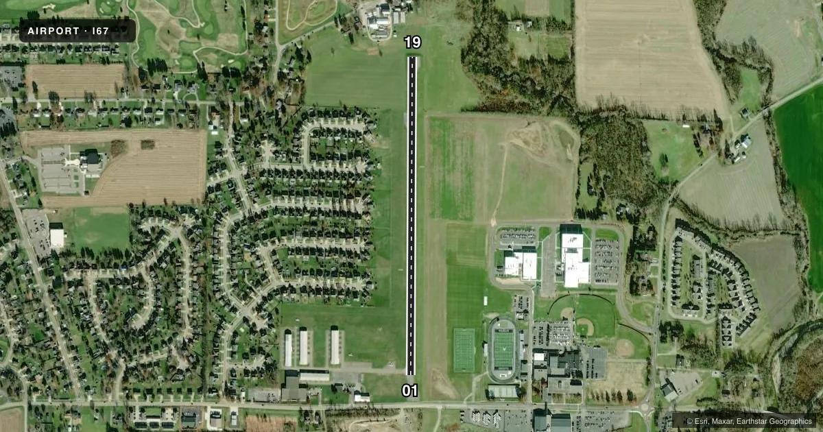
Airport sketch
Runways drawn to scale from FAA survey coordinates, rendered over satellite imagery. Not for navigation.
Approaches & charts
Services on the field
Fuel grades, oxygen, maintenance, ramp storage and lighting — as declared to the FAA by the airport operator.
Fuel & services
- Fuel
- 100LL
- Oxygen (bottled)
- Not available
- Oxygen (bulk)
- Not available
- Airframe repair
- Major
- Power plant repair
- Major
- Other services
- INSTR,RNTL,SALES
Ramp & ground
- Transient storage
- Tie-down
- Hangar
- Landing fee
- No fee published
- Customs
- Not available
- Lighting schedule
- SEE RMK
- Beacon schedule
- SS-SR
- Beacon
- White / Green (civil land)(WG)
- Wind indicator
- Lighted
- Segmented circle
- No
Fuel & FBOs
Cheapest 100LL and Jet A on the field and nearby. Always confirm with the FBO before taxi.
Airport notes
Surface conditions, obstructions, local procedures, lighting outages and other notes published with each FAA cycle.
General notes
- FOR CD CTC CINCINNATI APCH AT 859-372-6440.
Lighting notes
- ACTVT OR INCR INTST MIRL RWY 01/19 - CTAF. MIRL RWY 01/19 PRESET LOW INTST SS-SR. PAPI RWY 01 & 19 OPR CONSLY.
Fuel notes
- 100LLFUEL AVBL H24 SELF SVC.
Approach & departure obstructions
- 19+23 FT BLDG, 140 FT DIST, 240 FT R.
- 01PAPI UNUSBL BYD 7 DEGS RIGHT OF CNTRLN.
- 19PAPI UNUSBL BYD 9 DEGS LEFT OR RIGHT OF CNTRLN.
- 01APCH SLP 18:1 TO DTHR OVR +22 FT TREE, 329 DIST, 27 FT L.
- 19APCH SLP 12:1 TO DTHR OVR +59 FT TREE, 731 FT DIST, 33 FT R.
Other notes
- 1UNATNDD ALL MAJOR HOLS.
- MANAGEROR 513-367-5070.
VFR map & nearby airports
VFR sectional. Tap any ICAO chip to open that airport.
Key facts · I67
Answer card- ICAO
- I67
- Name
- CINCINNATI WEST
- Location
- HARRISON, OHIO
- Elevation
- 584.1 ft MSL
- Traffic pattern altitude
- 1,584.1 ft MSL (1,000 AGL)
- Control tower
- Non-towered (use CTAF)
- Total runways
- 1
- Longest runway
- 01/19 · 2,808 ft
- Published ILS approaches
- 0
- Published frequencies
- 4
- Magnetic variation
- 5°
- Current flight rules
- VFR
- Current wind
- 000° at 0 kt
- Favored runway now
- –
Cincinnati West Airport (I67) sits in Harrison, Ohio. The field elevation is 584.1 ft MSL. It has one runway, 01/19, which is 2,808 ft long and asphalt. There is no control tower. No ILS approaches are published here.
The pattern altitude is not published. Use 1,000 ft AGL for light piston operations unless the current Chart Supplement says otherwise. The airport uses CTAF and UNICOM 123.0. For clearance delivery, Cincinnati Approach can be reached at 859-372-6440. The on-field FBO is Cincinnati West Airport. It carries 100LL. Self-serve 100LL is available 24 hours a day.
A few published remarks matter for planning. The PAPI on runway 01 is unusable beyond 7 degrees right of centerline. The PAPI on runway 19 is unusable beyond 9 degrees left or right of centerline. There are also approach obstructions noted on both ends, including trees and a building near runway 19. The runway lights are preset to low intensity from sunset to sunrise. Medium intensity runway lights are activated on CTAF. The airport is unattended on all major holidays. For a first visit, keep the short runway length in mind and verify current remarks in the Chart Supplement before departure.