METAR & TAF KHLB
Current METAR
Observed 13:35Z
KHLB 271335Z AUTO 00000KT 8SM SCT017 SCT036 24/24 A2994 RMK A01
- Wind
- 000° @ 0 kt
- Visibility
- 8 SM
- Temp / Dew
- 24°C / 24°C
- Altimeter
- 29.94 inHg
- Clouds
- SCT
- Density alt
- 2,264 ft
- Ceiling
- Unlimited
- Rules
- VFR
Airport info & contacts
Manager on record, flight service, ARTCC, attendance schedule and pattern altitude — published by the FAA and refreshed every 28 days.
Location
- From city
- 3 NM NW
- VFR sectional
- ST LOUIS
- ARTCC
- ZID · INDIANAPOLIS
- NOTAM facility
- HUF
Airport manager
- Name
- PATRIC WELLS
- Phone
- 812-934-7593
- Address
- 25222 ENOCHSBURG RD., BATESVILLE IN 47006
Flight service · Hours
- FSS HUF
- TERRE HAUTE1-800-WX-BRIEF
- Attendance
- MON-FRI · 0800-1700 LOCAL
Frequencies
Tap any row to copy the frequency to your clipboard.
Runways & pattern
Full pagePattern entry · RWY 18
LEFT TRAFFICRunway end performance
| End | TORA | TODA | ASDA | LDA | VGSI | Approach lights | Obstruction |
|---|---|---|---|---|---|---|---|
| 18 | — | — | — | — | — | — | 67', trees, 600' from thr, 65' R of cntrln, slope 5 |
| 36 | — | — | — | — | PAPI 2-box right(3°) | — | 27', tree, 250' from thr, 160' R of cntrln, slope 1 |
Declared distances in feet. TORA = takeoff run available, TODA = takeoff distance, ASDA = accelerate-stop, LDA = landing distance.
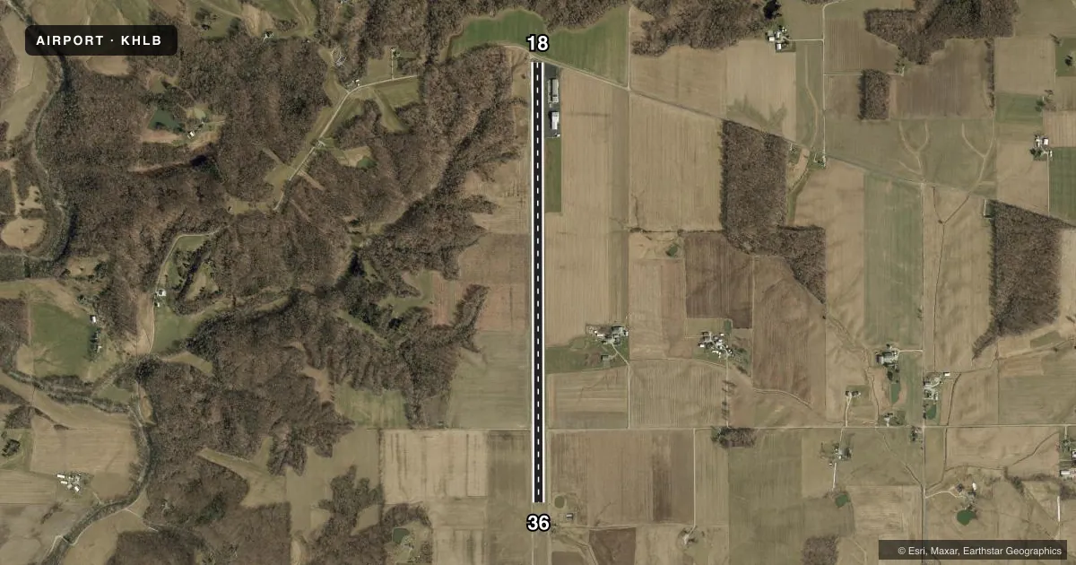
Airport sketch
Runways drawn to scale from FAA survey coordinates, rendered over satellite imagery. Not for navigation.
Approaches & charts
Services on the field
Fuel grades, oxygen, maintenance, ramp storage and lighting — as declared to the FAA by the airport operator.
Fuel & services
- Fuel
- A
- Airframe repair
- Major
- Power plant repair
- Minor
Ramp & ground
- Transient storage
- Tie-down
- Hangar
- Landing fee
- No fee published
- Lighting schedule
- SEE RMK
- Beacon schedule
- SS-SR
- Beacon
- White / Green (civil land)(WG)
- Wind indicator
- Yes
- Segmented circle
- No
Fuel & FBOs
Cheapest 100LL and Jet A on the field and nearby. Always confirm with the FBO before taxi.
Airport notes
Surface conditions, obstructions, local procedures, lighting outages and other notes published with each FAA cycle.
General notes
- FOR CD CTC CINCINNATI APCH AT 859-372-6440
- LNDG FAC IS FQTLY USED FOR MED AMBULANCE PURPOSES.
Lighting notes
- ACTVT HIRL RWY 18/36 - CTAF.
Approach & departure obstructions
- 18BLAST FENCE 10 FT FM RWY END; ROAD 25 FT FM RWY END; CROPS 60 FT FM RWY END.
- 18APCH RATIO 17:1 TO DTHR.
VFR map & nearby airports
VFR sectional. Tap any ICAO chip to open that airport.
Key facts · KHLB
Answer card- ICAO
- KHLB
- Name
- BATESVILLE
- Location
- BATESVILLE, INDIANA
- Elevation
- 975 ft MSL
- Traffic pattern altitude
- 1,975 ft MSL (1,000 AGL)
- Control tower
- Non-towered (use CTAF)
- Total runways
- 1
- Longest runway
- 18/36 · 5,933 ft
- Published ILS approaches
- 0
- Published frequencies
- 4
- Magnetic variation
- 5°
- Current flight rules
- VFR
- Current wind
- 000° at 0 kt
- Favored runway now
- –
Batesville Airport sits in Batesville, Indiana at 975 ft MSL. It has one runway. Runway 18/36 is 5,933 ft long and is the longest runway on the field. There is no control tower. CTAF and UNICOM are both 122.725. Cincinnati Approach handles approach and departure on 128.7 or 254.25. For clearance delivery, contact Cincinnati Approach at 859-372-6440.
No ILS approaches are published here. Pattern altitude is not published, so use the standard 1,000 ft AGL for light piston operations unless the current Chart Supplement says otherwise. The field is used frequently for medical ambulance operations, so expect that traffic to take priority when it is active. Runway 18 has a blast fence 10 feet from the runway end. A road sits 25 feet from the runway end. Crops are 60 feet from the runway end. The approach ratio is 17 to 1 to the decision height.
High intensity runway lights for 18/36 are activated on CTAF. Epicenter Aviation is on the field. It carries JET_A_PRIST. If you are planning a first stop here, pay close attention on short final to the runway 18 end obstacles. The runway is usable lengthwise, but the departure and arrival environment on 18 deserves a careful brief before you go.