METAR & TAF 12I
12I does not publish a METAR.
Showing the nearest reporting station: KOXD (MIAMI UNIVERSITY) · 10.2 NM away. Conditions at 12I may differ.
METAR · KOXD
Observed 08:35Z
KOXD 250835Z AUTO 00000KT 10SM CLR 14/14 A3008 RMK AO2 T01440144
- Wind
- 000° @ 0 kt
- Visibility
- 10 SM
- Temp / Dew
- 14°C / 14°C
- Altimeter
- 30.08 inHg
- Clouds
- CLR
- Density alt
- 609 ft
- Ceiling
- Unlimited
- Rules
- VFR
Airport info & contacts
Manager on record, flight service, ARTCC, attendance schedule and pattern altitude — published by the FAA and refreshed every 28 days.
Location
- From city
- 6 NM N
- VFR sectional
- ST LOUIS
- ARTCC
- ZID · INDIANAPOLIS
- NOTAM facility
- HUF (NOTAM-D)
Airport manager
- Name
- LT. KENTON TURNER
- Phone
- (317) 232-0935
- Address
- 402 W. WASHINGTON ST, RM. 2-255D, INDIANAPOLIS IN 46204
Flight service · Hours
- FSS HUF
- TERRE HAUTE1-800-WX-BRIEF
- Attendance
- Unattended
Frequencies
Tap any row to copy the frequency to your clipboard.
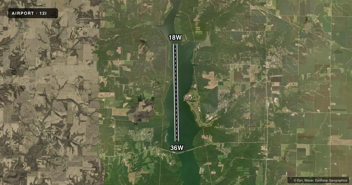
Runways & pattern
Full pagePattern entry · RWY 18W
LEFT TRAFFICRunway end performance
| End | TORA | TODA | ASDA | LDA | VGSI | Approach lights | Obstruction |
|---|---|---|---|---|---|---|---|
| 36W | — | — | — | — | — | — | bridge |
Declared distances in feet. TORA = takeoff run available, TODA = takeoff distance, ASDA = accelerate-stop, LDA = landing distance.
Airport sketch
Runways drawn to scale from FAA survey coordinates, rendered over satellite imagery. Not for navigation.
Approaches & charts
Services on the field
Fuel grades, oxygen, maintenance, ramp storage and lighting — as declared to the FAA by the airport operator.
Fuel & services
- Fuel
- Not available
Ramp & ground
- Transient storage
- Not published
- Segmented circle
- No
Fuel & FBOs
Cheapest 100LL and Jet A on the field and nearby. Always confirm with the FBO before taxi.
Airport notes
Surface conditions, obstructions, local procedures, lighting outages and other notes published with each FAA cycle.
General notes
- SEAPLANE OPS NA SS-SR.
- LAKE USE PERMIT RQRD - 765 647-2657.
- EXP HVY BOAT TFC MEMORIAL THRU LABOR DAY.
- FOR CD CTC CINCINNATI APCH AT 859-372-6440
Other notes
- & UNION COUNTY
- MANAGEREXT 0.
- OWNEREXT 0.
VFR map & nearby airports
VFR sectional. Tap any ICAO chip to open that airport.
Key facts · 12I
Answer card- ICAO
- 12I
- Name
- BROOKVILLE RESERVOIR
- Location
- BROOKVILLE, INDIANA
- Elevation
- 748 ft MSL
- Traffic pattern altitude
- 1,748 ft MSL (1,000 AGL)
- Control tower
- Non-towered (use CTAF)
- Total runways
- 1
- Longest runway
- 18W/36W · 16,000 ft
- Published ILS approaches
- 0
- Published frequencies
- 1
- Magnetic variation
- 3°
- Current flight rules
- VFR
- Current wind
- 000° at 0 kt
- Favored runway now
- –
Brookville Reservoir (12I) sits in Brookville, Indiana, in Union County. Field elevation is 748 ft MSL. The field has one runway. It is the 16,000 ft water runway 18W/36W with magnetic headings 179° and 359°. There is no control tower. CTAF is 122.9. No ILS approaches are published.
Pattern altitude is not published in the facts. Use the current FAA Chart Supplement before you go. The published remarks matter here. Expect heavy boat traffic from Memorial Day through Labor Day. A lake use permit is required. Call 765 647-2657 for that. Seaplane operations are not authorized from sunset to sunrise. For clearance delivery, contact Cincinnati Approach at 859-372-6440.
There are no on-field FBOs listed in the facts. Contact the airport operator directly before arrival, or call the field on CTAF for current FBO availability. This is a water runway, so plan for seaplane procedures and local lake traffic. Check the current FAA Chart Supplement for any published noise or curfew restrictions before flying into the field.