METAR & TAF 7I2
7I2 does not publish a METAR.
Showing the nearest reporting station: KMIE (DELAWARE COUNTY RGNL) · 6.3 NM away. Conditions at 7I2 may differ.
METAR · KMIE
Observed 15:15Z
KMIE 261515Z 00000KT 10SM BKN016 OVC021 23/20 A2997 RMK AO2 T02330200
- Wind
- 000° @ 0 kt
- Visibility
- 10 SM
- Temp / Dew
- 23°C / 20°C
- Altimeter
- 29.97 inHg
- Clouds
- OVC
- Density alt
- 2,127 ft
- Ceiling
- 1,600 ft AGL
- Rules
- MVFR
Airport info & contacts
Manager on record, flight service, ARTCC, attendance schedule and pattern altitude — published by the FAA and refreshed every 28 days.
Location
- From city
- 3 NM SE
- VFR sectional
- CHICAGO
- Pattern altitude
- 800 ft AGL · 1,791 ft MSL
- ARTCC
- ZID · INDIANAPOLIS
- NOTAM facility
- HUF (NOTAM-D)
Airport manager
- Name
- STEPHEN REESE
- Phone
- (765) 749-7357
- Address
- 11707 E CO RD 250 N - ORR RD, ALBANY IN 47320
Flight service · Hours
- FSS HUF
- TERRE HAUTE1-800-WX-BRIEF
- Attendance
- 0800-DUSK
Frequencies
Tap any row to copy the frequency to your clipboard.
Runways & pattern
Full pagePattern entry · RWY 09
LEFT TRAFFICRunway end performance
| End | TORA | TODA | ASDA | LDA | VGSI | Approach lights | Obstruction |
|---|---|---|---|---|---|---|---|
| 09 | — | — | — | — | — | — | 55', trees, 960' from thr, 45' R of cntrln, slope 13 |
| 27 | — | — | — | — | — | — | 15', road, 315' from thr, 0' R of cntrln, slope 7 |
Declared distances in feet. TORA = takeoff run available, TODA = takeoff distance, ASDA = accelerate-stop, LDA = landing distance.
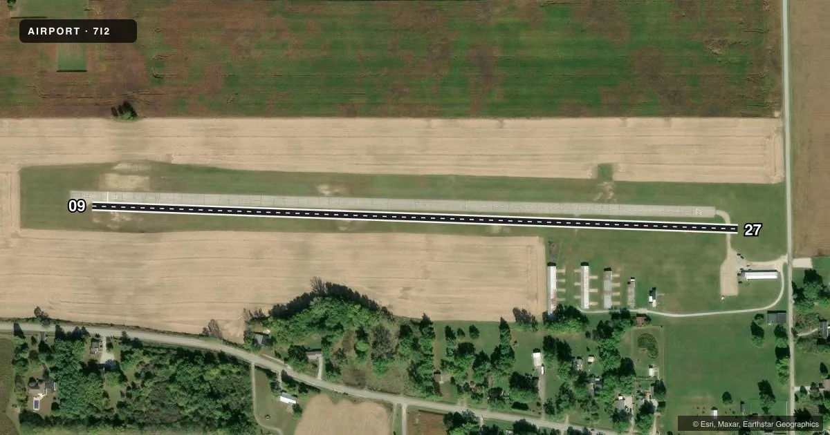
Airport sketch
Runways drawn to scale from FAA survey coordinates, rendered over satellite imagery. Not for navigation.
Approaches & charts
Services on the field
Fuel grades, oxygen, maintenance, ramp storage and lighting — as declared to the FAA by the airport operator.
Fuel & services
- Fuel
- 100LLUL94
- Other services
- INSTR,RNTL
Ramp & ground
- Transient storage
- Tie-down
- Landing fee
- No fee published
- Customs
- Not available
- Wind indicator
- Yes
- Segmented circle
- No
Fuel & FBOs
Cheapest 100LL and Jet A on the field and nearby. Always confirm with the FBO before taxi.
Airport notes
Surface conditions, obstructions, local procedures, lighting outages and other notes published with each FAA cycle.
General notes
- FOR CD CTC INDIANAPOLIS APCH AT 317-227-5743.
- UAS/MODEL AIRCRAFT ACTIITY 1/2 MILE NORTH OF AIRPORT.ACADAMY OF MODEL AERONAUTICS FLYING SITE.
Approach & departure obstructions
- 27CNTRLN MRKG FADED E END OF RWY.
- 09CROPS 200 FT FM RWY END
Other notes
- MANAGER765-284-9611.
VFR map & nearby airports
VFR sectional. Tap any ICAO chip to open that airport.
Key facts · 7I2
Answer card- ICAO
- 7I2
- Name
- REESE
- Location
- MUNCIE, INDIANA
- Elevation
- 991 ft MSL
- Traffic pattern altitude
- 1,791 ft MSL (800 AGL)
- Control tower
- Non-towered (use CTAF)
- Total runways
- 1
- Longest runway
- 09/27 · 2,800 ft
- Published ILS approaches
- 0
- Published frequencies
- 2
- Magnetic variation
- 3°
- Current flight rules
- MVFR
- Current wind
- 000° at 0 kt
- Favored runway now
- –
Reese (7I2) sits in Muncie, Indiana. The field elevation is 991 ft MSL. It has one runway. Runway 09/27 is 2,800 ft of asphalt, so plan performance with that length in mind. There is no control tower. CTAF and UNICOM are both 122.7.
Pattern altitude is 800 ft AGL, which is 1,791 ft MSL. No ILS approaches are published here, so check the current FAA Chart Supplement for the latest approach and arrival details before you go. Reese Flying Service is on the field. It carries UL94. Call ahead at (765) 284-9611 if you need current service info.
A few published remarks matter on a first visit. Clearance delivery is handled through Indianapolis Approach at 317-227-5743. There is model aircraft activity about one half mile north of the airport at the Academy of Model Aeronautics site. The east end of runway 27 has faded centerline markings. Crops are reported 200 feet from the end of runway 09, so keep that in mind on short final. This is an uncontrolled field, so standard see-and-avoid discipline matters. Verify current procedures in the FAA Chart Supplement before departure.