METAR & TAF 3I7
3I7 does not publish a METAR.
Showing the nearest reporting station: KDAY (JAMES M COX DAYTON INTL) · 8.4 NM away. Conditions at 3I7 may differ.
METAR · KDAY
Observed 04:56Z
KDAY 270456Z 23004KT 10SM FEW070 FEW250 20/19 A2993 RMK AO2 SLP128 T02000189 402720183
- Wind
- 230° @ 4 kt
- Visibility
- 10 SM
- Temp / Dew
- 20°C / 19°C
- Altimeter
- 29.93 inHg
- Clouds
- FEW
- Density alt
- 1,863 ft
- Ceiling
- Unlimited
- Rules
- VFR
Airport info & contacts
Manager on record, flight service, ARTCC, attendance schedule and pattern altitude — published by the FAA and refreshed every 28 days.
Location
- From city
- 13 NM NW
- VFR sectional
- CINCINNATI
- ARTCC
- ZID · INDIANAPOLIS
- NOTAM facility
- DAY (NOTAM-D)
Airport manager
- Name
- DANNY POTTER
- Phone
- 937-884-9795
- Address
- PO BOX 10, PHILLIPSBURG OH 45354-0010
Flight service · Hours
- FSS DAY
- DAYTON1-800-WX-BRIEF
- Attendance
- SUN · 1000-1700
- MON-SAT · 0900-1700
Frequencies
Tap any row to copy the frequency to your clipboard.
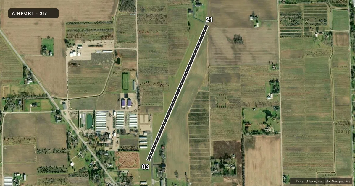
Runways & pattern
Full pagePattern entry · RWY 21
LEFT TRAFFICRunway end performance
| End | TORA | TODA | ASDA | LDA | VGSI | Approach lights | Obstruction |
|---|---|---|---|---|---|---|---|
| 03 | — | — | — | — | — | — | 68', tree, 650' from thr, 82' R of cntrln, slope 6 |
Declared distances in feet. TORA = takeoff run available, TODA = takeoff distance, ASDA = accelerate-stop, LDA = landing distance.
Airport sketch
Runways drawn to scale from FAA survey coordinates, rendered over satellite imagery. Not for navigation.
Approaches & charts
Services on the field
Fuel grades, oxygen, maintenance, ramp storage and lighting — as declared to the FAA by the airport operator.
Fuel & services
- Fuel
- 100LLA
- Oxygen (bottled)
- Not available
- Oxygen (bulk)
- HIGH/LOW
- Airframe repair
- Major
- Power plant repair
- Major
- Other services
- AVNCS,INSTR,RNTL,SALES
Ramp & ground
- Transient storage
- Tie-down
- Hangar
- Landing fee
- No fee published
- Customs
- Not available
- Lighting schedule
- SS-SR
- Beacon schedule
- SS-SR
- Beacon
- White / Green (civil land)(WG)
- Wind indicator
- Yes
- Segmented circle
- No
Fuel & FBOs
Cheapest 100LL and Jet A on the field and nearby. Always confirm with the FBO before taxi.
Airport notes
Surface conditions, obstructions, local procedures, lighting outages and other notes published with each FAA cycle.
General notes
- FOR CD CTC COLUMBUS APCH AT 614-338-8537.
Fuel notes
- 100LL100LL AVBL H24 SELF SVC VIA CREDIT CARD.
- AJET A AVBL ON REQ.
Approach & departure obstructions
- 0320 FT TWY, 0-92 FT DIST, 80-125 FT R.
- 2120 FT TWY, 0-60 FT DIST, 0-250 FT R.
- 03NSTD BASIC DUE TO NRS SML SIZE & NOT LCTD AT THR; CNTRLN SPACING; DTHR WHITE LN WITH NO ARROWS.
- 21NSTD BASIC DUE TO NRS SML SIZE & NOT LCTD AT THR; CNTRLN SPACING.
- 03APCH SLP 10:1 TO DTHR.
Other notes
- 2UNATNDD NEW YEARS, EASTER, THANKSGIVING, & CHRISTMAS.
VFR map & nearby airports
VFR sectional. Tap any ICAO chip to open that airport.
Key facts · 3I7
Answer card- ICAO
- 3I7
- Name
- DAYTON/PHILLIPSBURG
- Location
- DAYTON, OHIO
- Elevation
- 1,028.2 ft MSL
- Traffic pattern altitude
- 2,028.2 ft MSL (1,000 AGL)
- Control tower
- Non-towered (use CTAF)
- Total runways
- 1
- Longest runway
- 03/21 · 3,000 ft
- Published ILS approaches
- 0
- Published frequencies
- 4
- Magnetic variation
- 4°
- Current flight rules
- VFR
- Current wind
- 230° at 4 kt
- Favored runway now
- RWY 21
Dayton/Phillipsburg Airport (3I7) sits in Dayton, Ohio at 1,028.2 ft MSL. It has one runway. Runway 03/21 is 3,000 ft of asphalt, so plan for a short-field airport with some limits on margin. The field is non-towered. CTAF and UNICOM are both 122.7. For clearance delivery, Columbus Approach handles it on 614-338-8537. The published approach and departure frequencies are 134.45 and 352.05.
No ILS approaches are published here. Pattern altitude is not published, so use the standard 1,000 ft AGL for light piston traffic unless the current Chart Supplement says otherwise. Phillipsburg Airport is on the field. It carries 100LL and Jet A. 100LL is available 24 hours a day self-serve by credit card. Jet A is available on request.
There are a few runway details to brief before arrival. Runway 03 has a displaced threshold and nonstandard basic markings. Runway 21 also has nonstandard basic markings. Published remarks also call out taxiway obstructions near both runway ends. If you are new to the airport, study the current Chart Supplement before you go. The runway is short. The markings are unusual. The field is unattended on New Years, Easter, Thanksgiving and Christmas.