METAR & TAF 0D7
0D7 does not publish a METAR.
Showing the nearest reporting station: KAOH (LIMA ALLEN COUNTY) · 10.3 NM away. Conditions at 0D7 may differ.
METAR · KAOH
Observed 05:53Z
KAOH 120553Z AUTO 21010KT 10SM -RA FEW120 20/18 A2984 RMK AO2 RAB0454 SLP097 P0003 60005 T02000183 10294 20200 50015
- Wind
- 210° @ 10 kt
- Visibility
- 10 SM
- Temp / Dew
- 20°C / 18°C
- Altimeter
- 29.84 inHg
- Clouds
- FEW
- Density alt
- 1,876 ft
- Ceiling
- Unlimited
- Rules
- VFR
Airport info & contacts
Manager on record, flight service, ARTCC, attendance schedule and pattern altitude — published by the FAA and refreshed every 28 days.
Location
- From city
- 1 NM N
- VFR sectional
- DETROIT
- ARTCC
- ZID · INDIANAPOLIS
- NOTAM facility
- DAY (NOTAM-D)
Airport manager
- Name
- JEREMIAH BROWN
- Phone
- 618-351-9768
- Address
- 2646 TOWNSHIP ROAD 30, ADA OH 45810-9413
Flight service · Hours
- FSS DAY
- DAYTON1-800-WX-BRIEF
- Attendance
- Unattended
Frequencies
Tap any row to copy the frequency to your clipboard.
Runways & pattern
Full pagePattern entry · RWY 27
LEFT TRAFFICRunway end performance
| End | TORA | TODA | ASDA | LDA | VGSI | Approach lights | Obstruction |
|---|---|---|---|---|---|---|---|
| 09 | — | — | — | — | — | — | 60', tree, 0' from thr, 90' R of cntrln, slope 0 |
| 27 | — | — | — | — | — | — | 47', tree, 0' from thr, 110' R of cntrln, slope 0 |
Declared distances in feet. TORA = takeoff run available, TODA = takeoff distance, ASDA = accelerate-stop, LDA = landing distance.
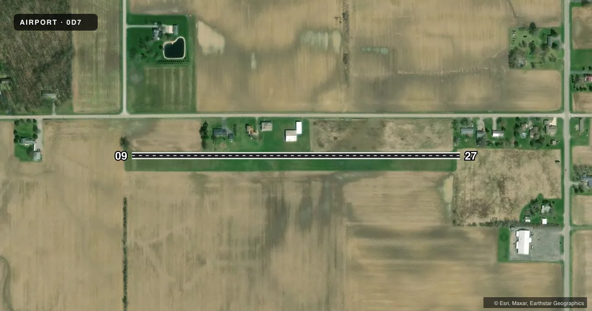
Airport sketch
Runways drawn to scale from FAA survey coordinates, rendered over satellite imagery. Not for navigation.
Approaches & charts
Services on the field
Fuel grades, oxygen, maintenance, ramp storage and lighting — as declared to the FAA by the airport operator.
Fuel & services
- Fuel
- Not available
- Oxygen (bottled)
- Not available
- Oxygen (bulk)
- Not available
- Airframe repair
- Not available
- Power plant repair
- Not available
Ramp & ground
- Transient storage
- Not published
- Landing fee
- No fee published
- Customs
- Not available
- Wind indicator
- No
- Segmented circle
- No
Fuel & FBOs
Cheapest 100LL and Jet A on the field and nearby. Always confirm with the FBO before taxi.
Airport notes
Surface conditions, obstructions, local procedures, lighting outages and other notes published with each FAA cycle.
General notes
- DEER, BIRDS, & WILDLIFE ON & INVOF ARPT.
- FOR CD CTC INDIANAPOLIS ARTCC AT 317-247-2411.
- ULTRALIGHT ACT ON & INVOF ARPT.
Runway surface & condition
- 09/27NGT OPS RSTRD.
Approach & departure obstructions
- 09+60 FT TREE, 0 FT DIST, 90 FT L.
- 27+47 FT TREE, 0 FT DIST, 110 FT R.
- 27+36 FT MKD PLINE 700 FT FM RWY 27 THR.
Other notes
- ESTABD BFR 1959.
VFR map & nearby airports
VFR sectional. Tap any ICAO chip to open that airport.
Key facts · 0D7
Answer card- ICAO
- 0D7
- Name
- ADA
- Location
- ADA, OHIO
- Elevation
- 949 ft MSL
- Traffic pattern altitude
- 1,949 ft MSL (1,000 AGL)
- Control tower
- Non-towered (use CTAF)
- Total runways
- 1
- Longest runway
- 09/27 · 1,955 ft
- Published ILS approaches
- 0
- Published frequencies
- 2
- Magnetic variation
- 5°
- Current flight rules
- VFR
- Current wind
- 210° at 10 kt
- Favored runway now
- RWY 27
ADA Airport (0D7) sits in ADA, Ohio at 949 ft MSL. It has one runway. Runway 09/27 is turf and measures 1,955 ft, so this is a short-field stop for light aircraft. There is no control tower. CTAF and UNICOM are both 122.8. No ILS approaches are published.
Pattern altitude is not published. Use the standard 1,000 ft AGL pattern unless the current Chart Supplement says otherwise. The field has no on-field FBOs listed, so plan fuel and service needs ahead of time with the airport operator or a local provider before you go. Published remarks call out a marked 36-foot power line 700 ft from the runway 27 threshold. They also note a 60-foot tree near the runway 09 end and a 47-foot tree near the runway 27 end. Deer, birds, wildlife and ultralight activity are also reported on and near the airport.
Night operations are restricted. That matters here. If you are planning a late arrival, verify the current Chart Supplement and coordinate with the airport operator before departure. For clearance delivery, the published contact is Indianapolis ARTCC at 317-247-2411. Expect a small-field environment with turf surface. Expect local traffic and close-in obstacles near both ends.