METAR & TAF 0G6
0G6 does not publish a METAR.
Showing the nearest reporting station: KDFI (DEFIANCE MEML) · 8.5 NM away. Conditions at 0G6 may differ.
METAR · KDFI
Observed 10:53Z
KDFI 271053Z AUTO 21004KT 5SM BR SCT045 20/19 A2990 RMK AO2 SLP120 T02000194
- Wind
- 210° @ 4 kt
- Visibility
- 5 SM
- Temp / Dew
- 20°C / 19°C
- Altimeter
- 29.90 inHg
- Clouds
- SCT
- Density alt
- 1,530 ft
- Ceiling
- Unlimited
- Rules
- MVFR
Airport info & contacts
Manager on record, flight service, ARTCC, attendance schedule and pattern altitude — published by the FAA and refreshed every 28 days.
Location
- From city
- 2 NM E
- VFR sectional
- DETROIT
- ARTCC
- ZOB · CLEVELAND
- NOTAM facility
- CLE (NOTAM-D)
Airport manager
- Name
- STEVE FORTNER
- Phone
- 419-630-4268
- Address
- 16288 COUNTY ROAD D, HANGAR C, BRYAN OH 43506-9802
Flight service · Hours
- FSS CLE
- CLEVELAND1-800-WX-BRIEF
- Attendance
- APR-NOV · 0800-1830
- DEC-MAR · 0800-1730
Frequencies
Tap any row to copy the frequency to your clipboard.
Runways & pattern
Full pagePattern entry · RWY 25
LEFT TRAFFICRunway end performance
| End | TORA | TODA | ASDA | LDA | VGSI | Approach lights | Obstruction |
|---|---|---|---|---|---|---|---|
| 07 | — | — | — | — | PAPI 4-box left(3°) | — | 16', road, 330' from thr, 275' R of cntrln, slope 8 |
| 25 | — | — | — | — | PAPI 4-box left(3°) | — | 16', road, 320' from thr, 265' R of cntrln, slope 7 |
Declared distances in feet. TORA = takeoff run available, TODA = takeoff distance, ASDA = accelerate-stop, LDA = landing distance.
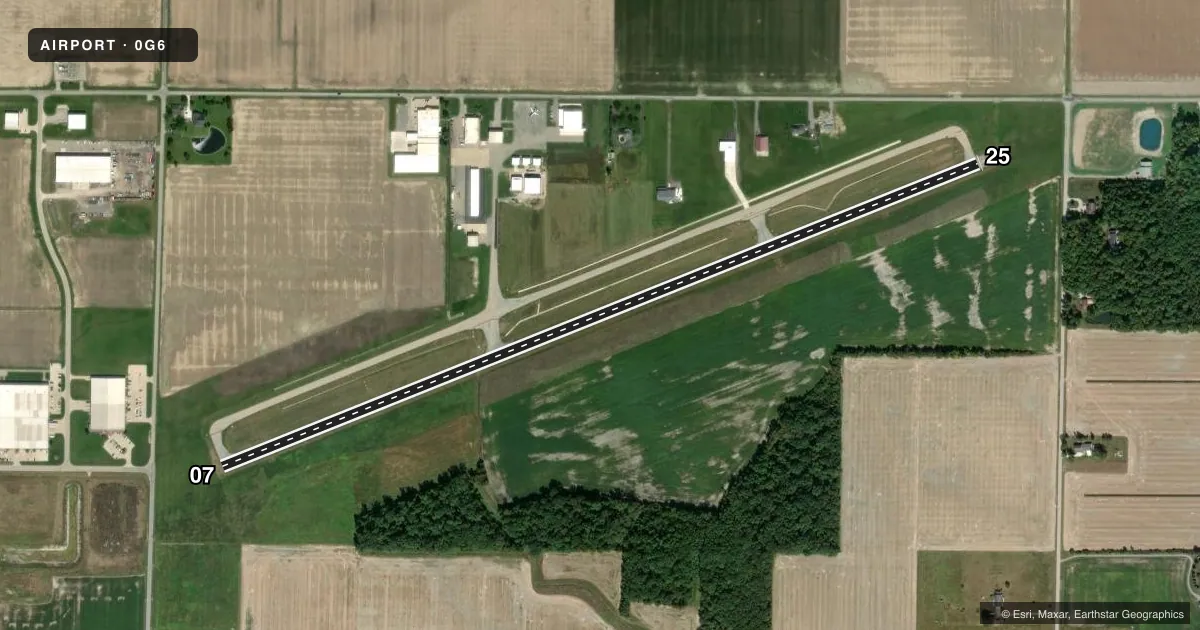
Airport sketch
Runways drawn to scale from FAA survey coordinates, rendered over satellite imagery. Not for navigation.
Approaches & charts
Services on the field
Fuel grades, oxygen, maintenance, ramp storage and lighting — as declared to the FAA by the airport operator.
Fuel & services
- Fuel
- 100LLA+
- Oxygen (bottled)
- Low pressure
- Oxygen (bulk)
- Not available
- Airframe repair
- Major
- Power plant repair
- Major
Ramp & ground
- Transient storage
- Tie-down
- Hangar
- Landing fee
- No fee published
- Customs
- Not available
- Lighting schedule
- SEE RMK
- Beacon schedule
- SS-SR
- Beacon
- White / Green (civil land)(WG)
- Wind indicator
- Lighted
- Segmented circle
- No
Fuel & FBOs
Cheapest 100LL and Jet A on the field and nearby. Always confirm with the FBO before taxi.
Airport notes
Surface conditions, obstructions, local procedures, lighting outages and other notes published with each FAA cycle.
General notes
- DEER, BIRDS, & WILDLIFE ON & INVOF ARPT.
- FOR CD CTC TOLEDO APCH AT 419-865-1495.
Lighting notes
- ACTVT REIL RWY 07 & 25; MIRL RWY 07/25 - 123.0.
Approach & departure obstructions
- 07APCH SLP 20:1 TO DTHR OVR 40 FT LGTD POLE, 823 FT DIST, 254 FT R.
- 25APCH SLP 16:1 TO DTHR OVR +77 FT TREE, 1291 FT DIST, 414 FT L.
Other notes
- PRIOR CDN RQRD.
- MANAGEROR 567-239-6664.
VFR map & nearby airports
VFR sectional. Tap any ICAO chip to open that airport.
Key facts · 0G6
Answer card- ICAO
- 0G6
- Name
- WILLIAMS COUNTY
- Location
- BRYAN, OHIO
- Elevation
- 729.6 ft MSL
- Traffic pattern altitude
- 1,729.6 ft MSL (1,000 AGL)
- Control tower
- Non-towered (use CTAF)
- Total runways
- 1
- Longest runway
- 07/25 · 4,782 ft
- Published ILS approaches
- 0
- Published frequencies
- 4
- Magnetic variation
- 5°
- Current flight rules
- MVFR
- Current wind
- 210° at 4 kt
- Favored runway now
- RWY 25
Williams County Airport (0G6) sits in Bryan, Ohio. The field elevation is 729.6 ft MSL. It has one runway, 07/25, which is 4,782 ft long and paved. There is no control tower. The published pattern altitude is not listed, so use standard 1,000 ft AGL for light piston traffic unless the current FAA Chart Supplement says otherwise.
No ILS approaches are published here. CTAF and UNICOM are both 122.8. The published remarks also note runway end identifier lights and medium intensity runway lights on both ends of 07/25. The airport remarks call out prior coordination, so plan ahead before arrival. Deer, birds and other wildlife are reported on and near the airport. There are also displaced-threshold obstacle notes on both runway ends, so pay attention to your approach path and landing distance planning.
Williams County Airport has one on-field FBO. Williams County Airport carries 100LL and Jet A. If you need clearance delivery, Toledo Approach is listed in the remarks. The airport is near the Ohio-Indiana border area. Expect a mix of local traffic and regional operations. Check the current FAA Chart Supplement before you go for any updated remarks or pattern guidance.