METAR & TAF KFWA
Current METAR
Observed 14:54Z
KFWA 271454Z 00000KT 6SM BR FEW037 OVC160 23/22 A2993 RMK AO2 RAE45 SLP131 P0001 60001 T02280217 58007
- Wind
- 000° @ 0 kt
- Visibility
- 6 SM
- Temp / Dew
- 23°C / 22°C
- Altimeter
- 29.93 inHg
- Clouds
- OVC
- Density alt
- 1,958 ft
- Ceiling
- 16,000 ft AGL
- Rules
- VFR
Airport info & contacts
Manager on record, flight service, ARTCC, attendance schedule and pattern altitude — published by the FAA and refreshed every 28 days.
Location
- From city
- 7 NM SW
- VFR sectional
- CHICAGO
- ARTCC
- ZAU · CHICAGO
- NOTAM facility
- FWA (NOTAM-D)
Airport manager
- Name
- SCOTT D. HINDERMAN
- Phone
- 260-747-4146
- Address
- 3801 WEST FERGUSON ROAD, SUITE 209, FORT WAYNE IN 46809
Flight service · Hours
- FSS HUF
- TERRE HAUTE1-800-WX-BRIEF
- Attendance
- 0500-2300
Frequencies
Tap any row to copy the frequency to your clipboard.
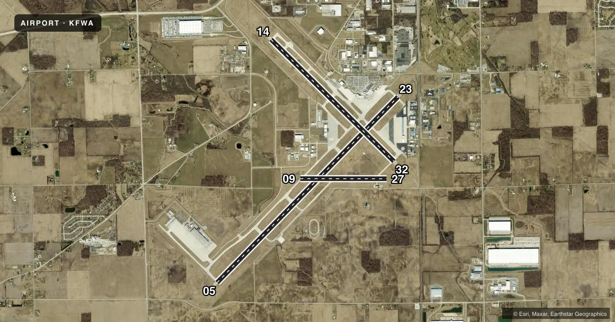
Runways & pattern
Full pagePattern entry · RWY 05
LEFT TRAFFIC| Runway | Heading (°M) | Length | Surface | Traffic |
|---|---|---|---|---|
| 05/23 | 38° / 218° | 11,981 ft | ASPH-CONC | Standard L |
| 14/32 | 129° / 309° | 8,002 ft | ASPH-CONC | Standard L |
| 09/27 | 84° / 264° | 4,001 ft | ASPH-CONC | Standard L |
Runway end performance
| End | TORA | TODA | ASDA | LDA | VGSI | Approach lights | Obstruction |
|---|---|---|---|---|---|---|---|
| 05 | 11,981' | 11,981' | 11,981' | 11,981' | — | ALSF2 | — |
| 23 | 11,981' | 11,981' | 11,981' | 11,981' | PAPI 4-box left(3°) | — | 23', rr, 800' from thr, 585' R of cntrln, slope 34 |
| 14 | 8,001' | 8,001' | 8,001' | 8,001' | PAPI 4-box left(3°) | — | 100', tree, 3672' from thr, 809' R of cntrln, slope 34 |
| 32 | 8,001' | 8,001' | 8,001' | 8,001' | PAPI 4-box left(3°) | MALSR | 26', rr, 1084' from thr, 625' R of cntrln, slope 50 |
| 09 | 4,001' | 4,001' | 4,001' | 4,001' | — | — | — |
| 27 | 4,001' | 4,001' | 4,001' | 4,001' | — | — | — |
Declared distances in feet. TORA = takeoff run available, TODA = takeoff distance, ASDA = accelerate-stop, LDA = landing distance.
Airport sketch
Runways drawn to scale from FAA survey coordinates, rendered over satellite imagery. Not for navigation.
Approaches & charts
ILS · 2
Services on the field
Fuel grades, oxygen, maintenance, ramp storage and lighting — as declared to the FAA by the airport operator.
Fuel & services
- Fuel
- 100LLAA+
- Oxygen (bottled)
- High pressure
- Airframe repair
- Major
- Power plant repair
- Major
- Other services
- AFRT,AMB,AVNCS,CARGO,CHTR,INSTR,RNTL,SALES
Ramp & ground
- Transient storage
- Tie-down
- Hangar
- Landing fee
- No fee published
- Customs
- Not available
- Beacon schedule
- SEE RMK
- Beacon
- White / Green (civil land)(WG)
- Wind indicator
- Lighted
- Segmented circle
- No
Fuel & FBOs
Cheapest 100LL and Jet A on the field and nearby. Always confirm with the FBO before taxi.
Airport notes
Surface conditions, obstructions, local procedures, lighting outages and other notes published with each FAA cycle.
General notes
- BIRDS ON & INVOF ARPT.
- TWY M & EAST RAMP MIL USE ONLY; OTR BY REQUEST - ANG 260-478-3202.
- TWY B ARM/DEARM AREA RSTRD TO MIL ACFT.
- TWY B/B, 1/B, 2/E & K CLSD TO WINGSPAN 79 FT OR GTR & WITH DUAL WHEEL TYPE LNDG GEAR IN EXCESS OF 50000 LB.
- ANG: PRK RAMP NSTD MRK INCL SOLID WHITE WINGTIP CLNC LINES BOTH SIDES OF TXL LCTD BTN E & W PRK ROWS, E & W OF BLDG 800 & MULT WHITE BOXES FOR ACFT GRD EQPT & MUNITIONS STORAGE AREA.
- ANG: UNUSE PAVEMENT FOR TAX LCTD CNTR OF APN WEST OF RSTD AREA - OPS FOR INFO.
- A-GEAR FOR LCL 122FW ONLY, PPR DSN 778-3202/3203 C800-842-3104 EXTN 202/203.
Lighting notes
- ATC-CTL
Fuel notes
- 100LLNC-100LL, A - CALLOUT FEE 0400-1000Z++.
Runway surface & condition
- 05/23PCR VALUE: 820/R/B/W/T
- 09/27PCR VALUE: 779/R/B/W/T
- 14/32PCR VALUE: 1089/R/B/W/T
- 09/27RWY 09/27 NOT AVBL FOR PART 121/PART 380 OPS WITH SKED PAX CARRYING OPS MORE THAN 9 PAX SEATS AND NON-SKED PAX CARRYING OPS MORE THAN 30 PAX SEATS. NO PART 121/PART 380 OPS EXC FOR TAX.
Arresting gear
- 14_BAK-12HOOK BAK-12B(B) (1650 FT).
- 32_BAK-12BBAK-12(B) (1332 FT).
Other notes
- ARFF INDEX C AVBL UPON REQ - 260-747-2624.
- 1AFT HR SVC - 260-747-2624.
VFR map & nearby airports
VFR sectional. Tap any ICAO chip to open that airport.
Key facts · KFWA
Answer card- ICAO
- KFWA
- Name
- FORT WAYNE INTL
- Location
- FORT WAYNE, INDIANA
- Elevation
- 814.5 ft MSL
- Traffic pattern altitude
- 1,814.5 ft MSL (1,000 AGL)
- Control tower
- Towered · 24
- Total runways
- 3
- Longest runway
- 05/23 · 11,981 ft
- Published ILS approaches
- 2
- Published frequencies
- 21
- Magnetic variation
- 6°
- Current flight rules
- VFR
- Current wind
- 000° at 0 kt
- Favored runway now
- –
Fort Wayne Intl is in Fort Wayne, Indiana. The field elevation is 814.5 ft MSL. It has three asphalt-concrete runways. The longest is 11,981 ft on 05/23. The airport is towered. The control tower is open 24 hours. Two ILS approaches are published for runway ends 05 and 32.
Pattern altitude is not published in the facts provided. Use the current FAA Chart Supplement before you go. The airport sits in a busy military and civilian environment, so expect restricted areas and local procedures that matter on the ground. Taxiway M and the east ramp are for military use only unless you have permission through the Air National Guard. Taxiway B arm and dearm area is also restricted to military aircraft. Runway 09/27 has limits for certain Part 121 and Part 380 passenger operations.
Fort Wayne Aero Center is on the field. It carries 100LL, Jet A and Jet A Prist. After-hours service is available by phone. If you need ARFF index C, it is available on request. For a first-time arrival, brief the runway lengths, the military ramp restrictions and the published fuel callout note before taxiing in.