METAR & TAF 0IA
0IA does not publish a METAR.
Showing the nearest reporting station: KASW (WARSAW MUNI) · 6.2 NM away. Conditions at 0IA may differ.
METAR · KASW
Observed 18:35Z
KASW 261835Z AUTO 25004KT 10SM BKN029 BKN035 27/20 A2995 RMK AO2 T02790200
- Wind
- 250° @ 4 kt
- Visibility
- 10 SM
- Temp / Dew
- 27°C / 20°C
- Altimeter
- 29.95 inHg
- Clouds
- BKN
- Density alt
- 2,442 ft
- Ceiling
- 2,900 ft AGL
- Rules
- MVFR
Airport info & contacts
Manager on record, flight service, ARTCC, attendance schedule and pattern altitude — published by the FAA and refreshed every 28 days.
Location
- From city
- 6 NM NE
- VFR sectional
- CHICAGO
- ARTCC
- ZAU · CHICAGO
- NOTAM facility
- HUF
Airport manager
- Name
- BRIAN BAILEY
- Phone
- 317-605-6023
- Address
- 402 WEST WASHINGTON ST, RM W-255D, INDIANAPOLIS IN 46204
Flight service · Hours
- FSS HUF
- TERRE HAUTE1-800-WX-BRIEF
Frequencies
Tap any row to copy the frequency to your clipboard.
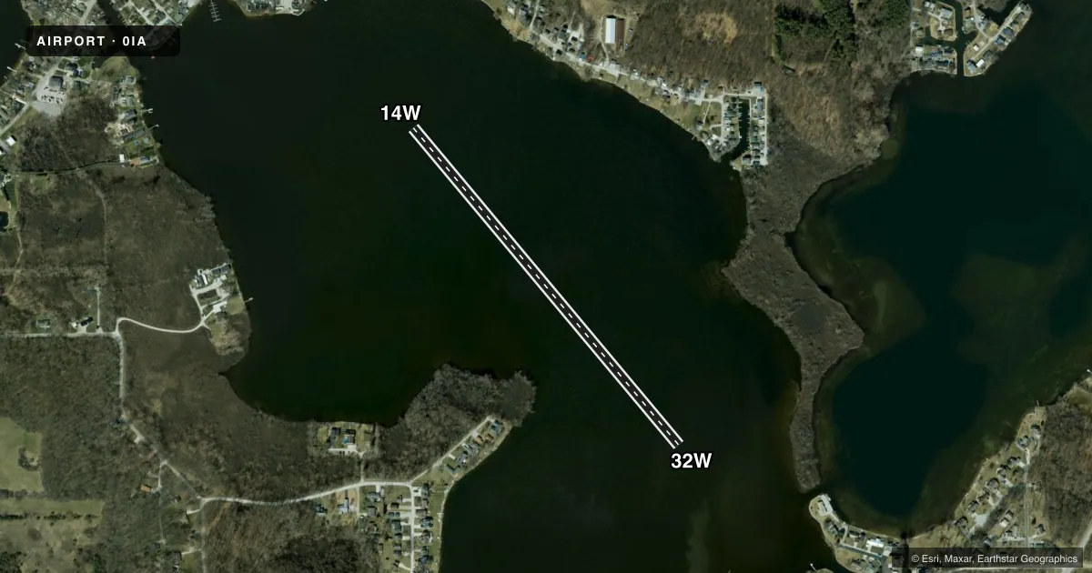
Runways & pattern
Full pagePattern entry · RWY 32W
LEFT TRAFFICAirport sketch
Runways drawn to scale from FAA survey coordinates, rendered over satellite imagery. Not for navigation.
Approaches & charts
Services on the field
Fuel grades, oxygen, maintenance, ramp storage and lighting — as declared to the FAA by the airport operator.
Fuel & services
- Fuel
- Not available
Ramp & ground
- Transient storage
- Not published
Fuel & FBOs
Cheapest 100LL and Jet A on the field and nearby. Always confirm with the FBO before taxi.
Airport notes
Surface conditions, obstructions, local procedures, lighting outages and other notes published with each FAA cycle.
General notes
- SEAPLANE OPS PROHIBITED BTN SS-SR. EXP HVY BOAT TFIC BTN MEMORIAL DAY AND LABOR DAY. DO NOT BLOCK BOAT RAMPS. SEAPLANE DOCKING AREAS LTD.
Other notes
- MANAGERBOATING LAW ADMIR.
VFR map & nearby airports
VFR sectional. Tap any ICAO chip to open that airport.
Key facts · 0IA
Answer card- ICAO
- 0IA
- Name
- BARBEE LAKE
- Location
- WARSAW, INDIANA
- Elevation
- 838 ft MSL
- Traffic pattern altitude
- 1,838 ft MSL (1,000 AGL)
- Control tower
- Non-towered (use CTAF)
- Total runways
- 1
- Longest runway
- 14W/32W · 2,675 ft
- Published ILS approaches
- 0
- Published frequencies
- 1
- Magnetic variation
- –
- Current flight rules
- MVFR
- Current wind
- 250° at 4 kt
- Favored runway now
- RWY 32W
Barbee Lake (0IA) sits in Warsaw, Indiana. The field elevation is 838 ft MSL. It has one runway. The longest is 14W/32W on water at 2,675 ft. There is no control tower. CTAF is 122.95.
No ILS approaches are published here. The pattern altitude is not published in the facts, so use the current FAA Chart Supplement before you fly. This is a seaplane field, so plan for water operations and local boat traffic. The published remarks say seaplane ops are prohibited between sunset and sunrise. They also note heavy boat traffic from Memorial Day through Labor Day. Do not block boat ramps. Docking areas are limited.
There are no on-field FBOs listed in the facts. Contact the airport operator directly before arrival. You can also call the field on CTAF for current local handling details. The manager is the boating law administrator. For a first visit, treat this as a water-operations stop with limited docking space. Verify current procedures, pattern expectations and any local restrictions in the current FAA Chart Supplement before departure.