METAR & TAF KASW
Current METAR
Observed 10:55Z
KASW 271055Z AUTO 00000KT 1 3/4SM BR OVC003 22/21 A2992 RMK AO2 T02200213
- Wind
- 000° @ 0 kt
- Visibility
- 0.75 SM
- Temp / Dew
- 22°C / 21°C
- Altimeter
- 29.92 inHg
- Clouds
- OVC
- Density alt
- 1,894 ft
- Ceiling
- 300 ft AGL
- Rules
- LIFR
Airport info & contacts
Manager on record, flight service, ARTCC, attendance schedule and pattern altitude — published by the FAA and refreshed every 28 days.
Location
- From city
- 2 NM N
- VFR sectional
- CHICAGO
- ARTCC
- ZAU · CHICAGO
- NOTAM facility
- ASW (NOTAM-D)
Airport manager
- Name
- NICHOLAS KING
- Phone
- 574-269-1337
- Address
- 3000 AIRPORT DR, WARSAW IN 46582
Flight service · Hours
- FSS HUF
- TERRE HAUTE1-800-WX-BRIEF
- Attendance
- MON-FRI · 0700-1900
- SAT-SUN · 0800-1800
Frequencies
Tap any row to copy the frequency to your clipboard.
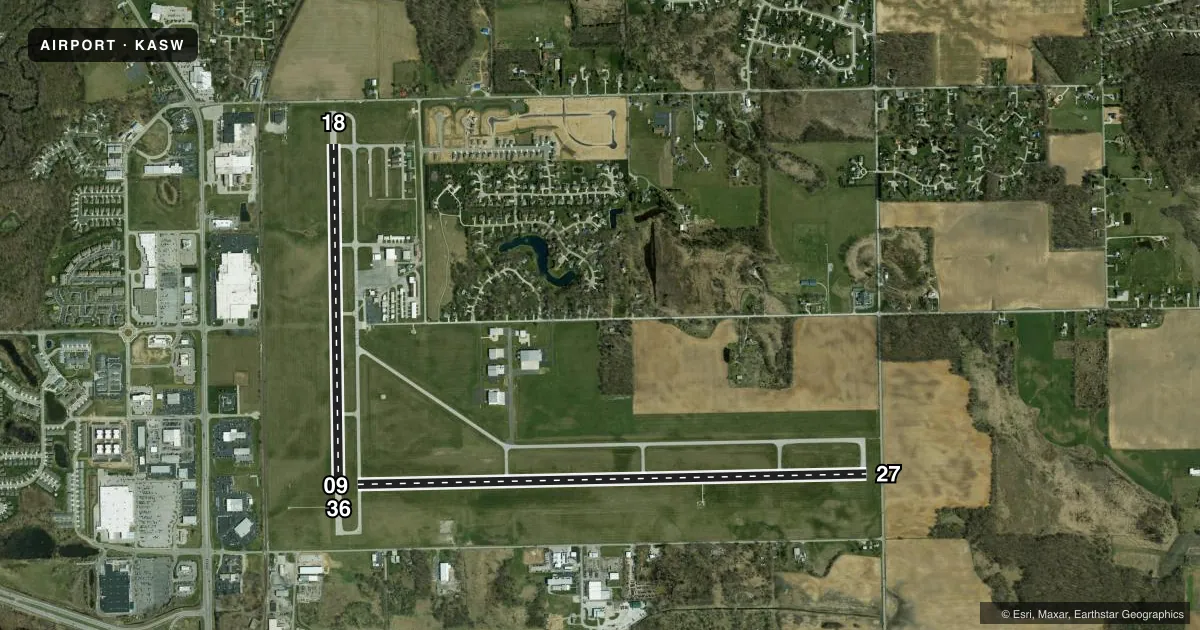
Runways & pattern
Full pagePattern entry · RWY 09
LEFT TRAFFIC| Runway | Heading (°M) | Length | Surface | Traffic |
|---|---|---|---|---|
| 09/27 | 86° / 266° | 6,001 ft | ASPH | Standard L |
| 18/36 | 176° / 356° | 4,021 ft | ASPH | Standard L |
Runway end performance
| End | TORA | TODA | ASDA | LDA | VGSI | Approach lights | Obstruction |
|---|---|---|---|---|---|---|---|
| 09 | 5,100' | 5,100' | 5,100' | 5,100' | PAPI 2-box left(3°) | — | 41', pole, 1460' from thr, 10' R of cntrln, slope 30 |
| 27 | 6,000' | 6,000' | 6,000' | 5,100' | PAPI 4-box left(3°) | — | 166', tower, 5600' from thr, 200' R of cntrln, slope 32 |
| 18 | — | — | — | — | VASI 4-box left(3.5°) | — | 15', road, 495' from thr, 0' R of cntrln, slope 19 |
| 36 | — | — | — | — | — | — | 28', tree, 1000' from thr, 165' R of cntrln, slope 28 |
Declared distances in feet. TORA = takeoff run available, TODA = takeoff distance, ASDA = accelerate-stop, LDA = landing distance.
Airport sketch
Runways drawn to scale from FAA survey coordinates, rendered over satellite imagery. Not for navigation.
Approaches & charts
ILS · 1
Services on the field
Fuel grades, oxygen, maintenance, ramp storage and lighting — as declared to the FAA by the airport operator.
Fuel & services
- Fuel
- 100LLA
- Airframe repair
- Major
- Power plant repair
- Major
- Other services
- AFRT,CHTR,INSTR,RNTL
Ramp & ground
- Transient storage
- Tie-down
- Hangar
- Landing fee
- No fee published
- Customs
- Not available
- Lighting schedule
- SEE RMK
- Beacon schedule
- SS-SR
- Beacon
- White / Green (civil land)(WG)
- Wind indicator
- Lighted
- Segmented circle
- Yes
Fuel & FBOs
Cheapest 100LL and Jet A on the field and nearby. Always confirm with the FBO before taxi.
Airport notes
Surface conditions, obstructions, local procedures, lighting outages and other notes published with each FAA cycle.
General notes
- FOR CD CTC CHICAGO ARTCC AT 630-906-8921.
Lighting notes
- ACTVT REIL RWY 09 & 27; PAPI RWY 09 & 27; MIRL RWY 18/36 - CTAF. VASI RWY 18 OPR CONSLY. HIRL RWY 09/27 PRESET TO LOW INTST; INCR INTST - CTAF.
Approach & departure obstructions
- 276 FT FENCE 1045 FT FM RWY END; 15 FT ROAD 1070 FT FM RWY END.
- 27CLOSEST ESTD INTCP OF TALLEST TWR.
- 27APCH SLOPE 34:1 TO DTHR.
Other notes
- PPR - AMGR.
- 1AFT HR - 574-372-9541
VFR map & nearby airports
VFR sectional. Tap any ICAO chip to open that airport.
Key facts · KASW
Answer card- ICAO
- KASW
- Name
- WARSAW MUNI
- Location
- WARSAW, INDIANA
- Elevation
- 849.7 ft MSL
- Traffic pattern altitude
- 1,849.7 ft MSL (1,000 AGL)
- Control tower
- Non-towered (use CTAF)
- Total runways
- 2
- Longest runway
- 09/27 · 6,001 ft
- Published ILS approaches
- 1
- Published frequencies
- 5
- Magnetic variation
- 3°
- Current flight rules
- LIFR
- Current wind
- 000° at 0 kt
- Favored runway now
- –
Warsaw Muni sits in Warsaw, Indiana at 849.7 ft MSL. It has two asphalt runways. The longest is 6,001 ft on runway 09/27. The field is non-towered. Pattern altitude is not published, so use 1,000 ft AGL for light piston traffic unless the current Chart Supplement says otherwise.
Runway 27 has the published ILS. Runway 09 and 27 also have runway end identifier lights and PAPI. Runway 18/36 has medium intensity runway lights controlled by CTAF. The VASI on runway 18 operates continuously. The airport uses CTAF 122.7. UNICOM is also 122.7. For clearance delivery, Chicago ARTCC can be reached at 630-906-8921. Towered traffic is not part of the picture here. Self-announce early and keep an eye out for local traffic.
Warsaw Municipal Airport is on the field. It carries AVGAS 100LL, JET A and JET A PRIST. Prior permission is required from the airport manager. After hours, contact 574-372-9541. Runway 27 has published obstacle notes near the displaced threshold. There is also a fence and a road close to the runway end. Treat 27 with care on approach and landing. If you are new to the field, verify the current Chart Supplement and call ahead before arrival.