METAR & TAF C92
C92 does not publish a METAR.
Showing the nearest reporting station: KRCR (FULTON COUNTY) · 7.4 NM away. Conditions at C92 may differ.
METAR · KRCR
Observed 12:55Z
KRCR 251255Z AUTO 10SM FEW044 OVC120 19/15 A3008 RMK AO2
- Wind
- Calm
- Visibility
- 10 SM
- Temp / Dew
- 19°C / 15°C
- Altimeter
- 30.08 inHg
- Clouds
- OVC
- Density alt
- 1,348 ft
- Ceiling
- 12,000 ft AGL
- Rules
- VFR
Airport info & contacts
Manager on record, flight service, ARTCC, attendance schedule and pattern altitude — published by the FAA and refreshed every 28 days.
Location
- From city
- 2 NM SW
- VFR sectional
- CHICAGO
- ARTCC
- ZAU · CHICAGO
- NOTAM facility
- HUF (NOTAM-D)
Airport manager
- Name
- JANE FELDMAN
- Phone
- 574-353-7227
- Address
- 12296 WEST 600 SOUTH, MENTONE IN 46539
Flight service · Hours
- FSS HUF
- TERRE HAUTE1-800-WX-BRIEF
- Attendance
- IREG
Frequencies
Tap any row to copy the frequency to your clipboard.
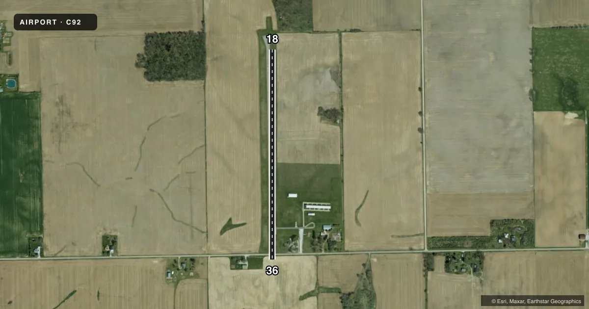
Runways & pattern
Full pagePattern entry · RWY 18
LEFT TRAFFICRunway end performance
| End | TORA | TODA | ASDA | LDA | VGSI | Approach lights | Obstruction |
|---|---|---|---|---|---|---|---|
| 18 | — | — | — | — | — | — | 55', trees, 275' from thr, 130' R of cntrln, slope 0 |
| 36 | — | — | — | — | — | — | 75', trees, 1550' from thr, 0' R of cntrln, slope 18 |
Declared distances in feet. TORA = takeoff run available, TODA = takeoff distance, ASDA = accelerate-stop, LDA = landing distance.
Airport sketch
Runways drawn to scale from FAA survey coordinates, rendered over satellite imagery. Not for navigation.
Approaches & charts
Services on the field
Fuel grades, oxygen, maintenance, ramp storage and lighting — as declared to the FAA by the airport operator.
Fuel & services
- Fuel
- Not available
Ramp & ground
- Transient storage
- Tie-down
- Hangar
- Landing fee
- No fee published
- Customs
- Not available
- Wind indicator
- Yes
- Segmented circle
- No
Fuel & FBOs
Cheapest 100LL and Jet A on the field and nearby. Always confirm with the FBO before taxi.
Airport notes
Surface conditions, obstructions, local procedures, lighting outages and other notes published with each FAA cycle.
General notes
- CROPS 110 FT EAST & WEST OF RWY CENTERLINE
- FOR CD CTC CHICAGO ARTCC AT 630-906-8921.
Approach & departure obstructions
- 18CROPS 80 FM RWY END
- 18RWY 18 APCH SLOPE 20:1 FM DSPLCD THLD
VFR map & nearby airports
VFR sectional. Tap any ICAO chip to open that airport.
Key facts · C92
Answer card- ICAO
- C92
- Name
- MENTONE
- Location
- MENTONE, INDIANA
- Elevation
- 860 ft MSL
- Traffic pattern altitude
- 1,860 ft MSL (1,000 AGL)
- Control tower
- Non-towered (use CTAF)
- Total runways
- 1
- Longest runway
- 18/36 · 2,521 ft
- Published ILS approaches
- 0
- Published frequencies
- 1
- Magnetic variation
- 2°
- Current flight rules
- VFR
- Current wind
- Calm / unavailable
- Favored runway now
- –
Mentone Airport (C92) sits in Mentone, Indiana. The field elevation is 860 ft MSL. It has one runway, 18/36, which is 2,521 ft long and paved with asphalt. There is no control tower. CTAF is 122.9.
No ILS approaches are published here. The pattern altitude is not published, so use the standard 1,000 ft AGL for light piston operations unless the current Chart Supplement says otherwise. That puts the traffic pattern at 1,860 ft MSL based on the field elevation, but verify the published pattern before you fly. The runway headings are magnetic. Magnetic variation is 2°.
The published remarks matter here. Crops are close to the runway ends. Crops are also reported east and west of the runway centerline. The runway 18 approach slope is noted as 20 to 1 from the displaced threshold. That means a stabilized approach is important, especially if you are coming in low or at a shallow angle. There are no on-field FBOs listed, so plan ahead for fuel and services. Check the current FAA Chart Supplement or call the airport operator before departure for any updated local information.