METAR & TAF IN9
IN9 does not publish a METAR.
Showing the nearest reporting station: KASW (WARSAW MUNI) · 7.7 NM away. Conditions at IN9 may differ.
METAR · KASW
Observed 17:35Z
KASW 241735Z AUTO 00000KT 10SM CLR 23/11 A3016 RMK AO2 T02320113
- Wind
- 000° @ 0 kt
- Visibility
- 10 SM
- Temp / Dew
- 23°C / 11°C
- Altimeter
- 30.16 inHg
- Clouds
- CLR
- Density alt
- 1,726 ft
- Ceiling
- Unlimited
- Rules
- VFR
Airport info & contacts
Manager on record, flight service, ARTCC, attendance schedule and pattern altitude — published by the FAA and refreshed every 28 days.
Location
- From city
- 1 NM NE
- VFR sectional
- CHICAGO
- ARTCC
- ZAU · CHICAGO
- NOTAM facility
- HUF
Airport manager
- Name
- KENTON TURNER
- Phone
- 317-232-0935
- Address
- 402 W. WASHINGTON ST., RM W-255D, INDIANAPOLIS IN 46204
Flight service · Hours
- FSS HUF
- TERRE HAUTE1-800-WX-BRIEF
Frequencies
Tap any row to copy the frequency to your clipboard.
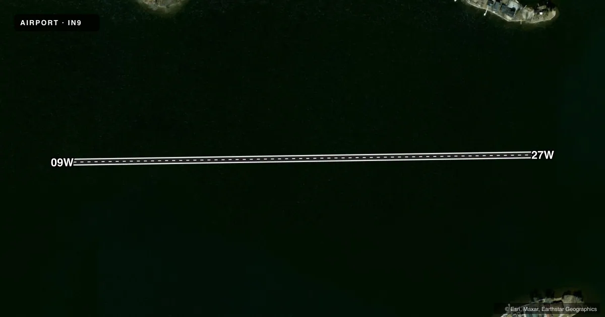
Runways & pattern
Full pagePattern entry · RWY 09W
LEFT TRAFFICAirport sketch
Runways drawn to scale from FAA survey coordinates, rendered over satellite imagery. Not for navigation.
Approaches & charts
Services on the field
Fuel grades, oxygen, maintenance, ramp storage and lighting — as declared to the FAA by the airport operator.
Fuel & services
- Fuel
- Not available
Ramp & ground
- Transient storage
- Not published
Fuel & FBOs
Cheapest 100LL and Jet A on the field and nearby. Always confirm with the FBO before taxi.
Airport notes
Surface conditions, obstructions, local procedures, lighting outages and other notes published with each FAA cycle.
VFR map & nearby airports
VFR sectional. Tap any ICAO chip to open that airport.
Key facts · IN9
Answer card- ICAO
- IN9
- Name
- WEBSTER LAKE
- Location
- NORTH WEBSTER, INDIANA
- Elevation
- 858 ft MSL
- Traffic pattern altitude
- 1,858 ft MSL (1,000 AGL)
- Control tower
- Non-towered (use CTAF)
- Total runways
- 1
- Longest runway
- 09W/27W · 2,675 ft
- Published ILS approaches
- 0
- Published frequencies
- 1
- Magnetic variation
- –
- Current flight rules
- VFR
- Current wind
- 000° at 0 kt
- Favored runway now
- –
Webster Lake (IN9) sits in North Webster, Indiana. Field elevation is 858 ft MSL. This is a water airport with one runway. The longest runway is 09W/27W at 2,675 ft. There is no control tower. CTAF is 122.9.
No ILS approaches are published here. Pattern altitude is not published, so use the standard 1,000 ft AGL for light piston traffic unless the current Chart Supplement says otherwise. The field is in a lake environment, so plan for water operations. Keep local traffic discipline tight on a single water runway. Magnetic variation is not listed in the facts, so verify runway alignment and any local procedures before arrival.
There are no on-field FBOs listed. If you need fuel or local services, contact the airport operator or call the field directly before you go. There are no published remarks in the facts provided. For first-time arrivals, the main thing to confirm is current water runway use, traffic flow and any local operating notes in the current Chart Supplement.