METAR & TAF C03
C03 does not publish a METAR.
Showing the nearest reporting station: KGSH (GOSHEN MUNI) · 8.0 NM away. Conditions at C03 may differ.
METAR · KGSH
Observed 12:20Z
KGSH 271220Z AUTO 17007KT 1 3/4SM -RA BR OVC003 22/22 A2987 RMK AO2 LTG DSNT NW RAB20 P0000 T02220217
- Wind
- 170° @ 7 kt
- Visibility
- 0.75 SM
- Temp / Dew
- 22°C / 22°C
- Altimeter
- 29.87 inHg
- Clouds
- OVC
- Density alt
- 1,968 ft
- Ceiling
- 300 ft AGL
- Rules
- LIFR
Airport info & contacts
Manager on record, flight service, ARTCC, attendance schedule and pattern altitude — published by the FAA and refreshed every 28 days.
Location
- From city
- 3 NM E
- VFR sectional
- CHICAGO
- ARTCC
- ZAU · CHICAGO
- NOTAM facility
- HUF (NOTAM-D)
Airport manager
- Name
- LLOYD TURNER
- Phone
- 574-457-6476
- Address
- 24751 US6E, NAPPANEE IN 46550
Flight service · Hours
- FSS HUF
- TERRE HAUTE1-800-WX-BRIEF
- Attendance
- 0800-1700
Frequencies
Tap any row to copy the frequency to your clipboard.
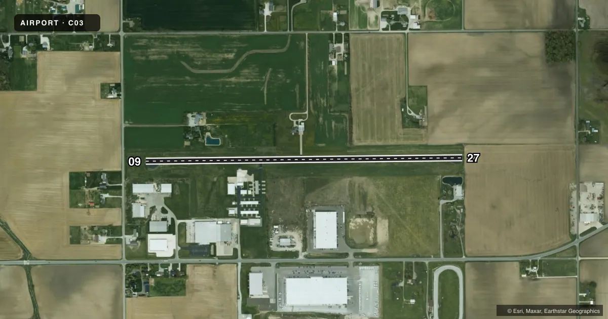
Runways & pattern
Full pagePattern entry · RWY 09
LEFT TRAFFICRunway end performance
| End | TORA | TODA | ASDA | LDA | VGSI | Approach lights | Obstruction |
|---|---|---|---|---|---|---|---|
| 09 | — | — | — | — | — | — | 13', road, 265' from thr, 0' R of cntrln, slope 5 |
| 27 | — | — | — | — | — | — | 5', crops, 201' from thr, 0' R of cntrln, slope 0 |
Declared distances in feet. TORA = takeoff run available, TODA = takeoff distance, ASDA = accelerate-stop, LDA = landing distance.
Airport sketch
Runways drawn to scale from FAA survey coordinates, rendered over satellite imagery. Not for navigation.
Approaches & charts
Services on the field
Fuel grades, oxygen, maintenance, ramp storage and lighting — as declared to the FAA by the airport operator.
Fuel & services
- Fuel
- 100LL
- Airframe repair
- Not available
- Power plant repair
- Not available
Ramp & ground
- Transient storage
- Tie-down
- Landing fee
- No fee published
- Customs
- Not available
- Lighting schedule
- SEE RMK
- Beacon schedule
- SS-SR
- Beacon
- White / Green (civil land)(WG)
- Wind indicator
- Lighted
- Segmented circle
- No
Fuel & FBOs
Cheapest 100LL and Jet A on the field and nearby. Always confirm with the FBO before taxi.
Airport notes
Surface conditions, obstructions, local procedures, lighting outages and other notes published with each FAA cycle.
General notes
- DEER ON & INVOF ARPT.
- FOR CD CTC SOUTH BEND APCH AT 574-251-2609. WHEN SOUTH BEND APCH CLSD, FOR CD CTC CHICAGO ARTCC AT 630-906-8921.
Lighting notes
- ACTVT MIRL RWY 09/27 - CTAF.
Fuel notes
- 100LLAVBL AFT HR WITH CREDIT CARD.
Runway surface & condition
- 09/27FIRST 670 FT RWY 09 UNLGTD.
Approach & departure obstructions
- 275 FT CROPS 20 - 200 FT FM RWY END ON CNTRLN.
- 09APCH RATIO 39:1 TO DTHR.
- 27APCH RATIO 41:1 TO DTHR.
VFR map & nearby airports
VFR sectional. Tap any ICAO chip to open that airport.
Key facts · C03
Answer card- ICAO
- C03
- Name
- NAPPANEE MUNI
- Location
- NAPPANEE, INDIANA
- Elevation
- 860 ft MSL
- Traffic pattern altitude
- 1,860 ft MSL (1,000 AGL)
- Control tower
- Non-towered (use CTAF)
- Total runways
- 1
- Longest runway
- 09/27 · 3,675 ft
- Published ILS approaches
- 0
- Published frequencies
- 4
- Magnetic variation
- 0°
- Current flight rules
- LIFR
- Current wind
- 170° at 7 kt
- Favored runway now
- RWY 09
Nappanee Muni Airport (C03) sits in Nappanee, Indiana. Field elevation is 860 ft MSL. The airport has one runway, 09/27, which is 3,675 ft long and paved with asphalt. There is no control tower. CTAF and UNICOM are both 123.0. Approach and departure support is through South Bend on 132.05 or 257.8. No ILS approaches are published here.
Pattern altitude is not published, so use the standard 1,000 ft AGL for light piston traffic unless the current FAA Chart Supplement says otherwise. That puts the pattern at 1,860 ft MSL based on the field elevation. The on-field FBO is Nappanee Municipal Airport. It carries 100LL. After-hours 100LL is available with a credit card.
A few operational points matter here. Runway 09/27 uses medium intensity lights that are activated by CTAF. The first 670 ft of runway 09 is unlighted. Published remarks also call out crops near the runway 27 end. They also mention deer on and near the airport, plus displaced threshold approach ratios on both ends. If you are planning a first visit, brief the runway lighting, watch the threshold environment on 27 and verify current clearance delivery details with South Bend Approach or Chicago ARTCC if needed.