METAR & TAF KGSH
Current METAR
Observed 15:21Z
KGSH 261521Z AUTO 23005KT 10SM OVC010 23/21 A2995 RMK AO2 T02280206
- Wind
- 230° @ 5 kt
- Visibility
- 10 SM
- Temp / Dew
- 23°C / 21°C
- Altimeter
- 29.95 inHg
- Clouds
- OVC
- Density alt
- 1,948 ft
- Ceiling
- 1,000 ft AGL
- Rules
- MVFR
Airport info & contacts
Manager on record, flight service, ARTCC, attendance schedule and pattern altitude — published by the FAA and refreshed every 28 days.
Location
- From city
- 3 NM SE
- VFR sectional
- CHICAGO
- ARTCC
- ZAU · CHICAGO
- NOTAM facility
- GSH (NOTAM-D)
Airport manager
- Name
- RANDY SHARKEY
- Phone
- 574-238-1000
- Address
- 17229 CR 42, GOSHEN IN 46526
Flight service · Hours
- FSS HUF
- TERRE HAUTE1-800-WX-BRIEF
- Attendance
- MON-SAT · 0700-1800
- SUN · 0900-1700
Frequencies
Tap any row to copy the frequency to your clipboard.
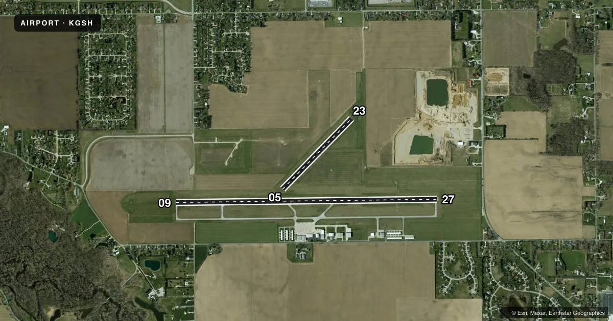
Runways & pattern
Full pagePattern entry · RWY 23
LEFT TRAFFIC| Runway | Heading (°M) | Length | Surface | Traffic |
|---|---|---|---|---|
| 09/27 | 85° / 265° | 6,008 ft | ASPH | Standard L |
| 05/23Favored | 40° / 220° | 2,267 ft | TURF | Standard L |
Runway end performance
| End | TORA | TODA | ASDA | LDA | VGSI | Approach lights | Obstruction |
|---|---|---|---|---|---|---|---|
| 09 | — | — | — | — | PAPI 2-box left(3.5°) | — | 59', tree, 1976' from thr, 117' R of cntrln, slope 30 |
| 27 | — | — | — | — | PAPI 4-box left(3°) | — | 83', tree, 3630' from thr, 210' R of cntrln, slope 44 |
| 23 | — | — | — | — | — | — | 105', pline, 4020' from thr, 0' R of cntrln, slope 38 |
Declared distances in feet. TORA = takeoff run available, TODA = takeoff distance, ASDA = accelerate-stop, LDA = landing distance.
Airport sketch
Runways drawn to scale from FAA survey coordinates, rendered over satellite imagery. Not for navigation.
Approaches & charts
ILS · 1
Services on the field
Fuel grades, oxygen, maintenance, ramp storage and lighting — as declared to the FAA by the airport operator.
Fuel & services
- Fuel
- 100LLA
- Oxygen (bottled)
- High pressure
- Airframe repair
- Major
- Power plant repair
- Major
- Other services
- AFRT,CARGO,CHTR,INSTR,RNTL
Ramp & ground
- Transient storage
- Tie-down
- Hangar
- Landing fee
- No fee published
- Customs
- Not available
- Lighting schedule
- SEE RMK
- Beacon schedule
- SS-SR
- Beacon
- White / Green (civil land)(WG)
- Wind indicator
- Lighted
- Segmented circle
- No
Fuel & FBOs
Cheapest 100LL and Jet A on the field and nearby. Always confirm with the FBO before taxi.
Airport notes
Surface conditions, obstructions, local procedures, lighting outages and other notes published with each FAA cycle.
General notes
- FOR CD CTC SOUTH BEND APCH AT 574-251-2609. WHEN SOUTH BEND APCH CLSD, FOR CD CTC CHICAGO ARTCC AT 630-906-8921.
Lighting notes
- ACTVT REIL RWY 09 & 27; PAPI RWY 09 & 27 - CTAF. HIRL RWY 09/27 PRESET LOW INTST; INCR INTST - CTAF.
Approach & departure obstructions
- 05YELLOW CONES.
- 23YELLOW CONES.
Other notes
- MANAGEROR 574-238-1000. ALSO, A 24-HR PHONE AVBL.
VFR map & nearby airports
VFR sectional. Tap any ICAO chip to open that airport.
Key facts · KGSH
Answer card- ICAO
- KGSH
- Name
- GOSHEN MUNI
- Location
- GOSHEN, INDIANA
- Elevation
- 826.4 ft MSL
- Traffic pattern altitude
- 1,826.4 ft MSL (1,000 AGL)
- Control tower
- Non-towered (use CTAF)
- Total runways
- 2
- Longest runway
- 09/27 · 6,008 ft
- Published ILS approaches
- 1
- Published frequencies
- 5
- Magnetic variation
- 4°
- Current flight rules
- MVFR
- Current wind
- 230° at 5 kt
- Favored runway now
- RWY 23
Goshen Muni sits in Goshen, Indiana. Field elevation is 826.4 ft MSL. The airport has two runways. The longest is runway 09/27 at 6,008 ft. Runway 05/23 is turf and 2,267 ft long. There is no control tower, so plan for CTAF traffic flow and self-announced position calls.
One ILS approach is published for runway 27. Pattern altitude is not published. Use the standard 1,000 ft AGL pattern for light piston aircraft unless the current Chart Supplement says otherwise. The field is close enough to South Bend approach coverage that clearance delivery is handled through South Bend Approach when available. If South Bend Approach is closed, clearance delivery goes through Chicago ARTCC.
Sweet Aviation is on the field. It carries 100LL, Jet A and Jet A Prist. The published remarks also note that runway 09 and 27 have active runway end identifier lights. The PAPI on 09 and 27 is controlled on CTAF. High intensity lights on 09/27 start at low intensity. Increase them on CTAF if needed. Yellow cones mark the ends of runway 05 and runway 23. First-time arrivals should pay attention to the turf runway. They should also brief the lighting setup on 09/27 and the non-towered pattern work.