METAR & TAF 0IN
0IN does not publish a METAR.
Showing the nearest reporting station: KEKM (ELKHART MUNI) · 3.2 NM away. Conditions at 0IN may differ.
METAR · KEKM
Observed 10:35Z
KEKM 271035Z AUTO 18004KT 9SM FEW039 22/22 A2988 RMK AO2 T02240224 $
- Wind
- 180° @ 4 kt
- Visibility
- 9 SM
- Temp / Dew
- 22°C / 22°C
- Altimeter
- 29.88 inHg
- Clouds
- FEW
- Density alt
- 1,820 ft
- Ceiling
- Unlimited
- Rules
- VFR
Airport info & contacts
Manager on record, flight service, ARTCC, attendance schedule and pattern altitude — published by the FAA and refreshed every 28 days.
Location
- From city
- 2 NM NE
- VFR sectional
- CHICAGO
- ARTCC
- ZAU · CHICAGO
- NOTAM facility
- HUF (NOTAM-D)
Airport manager
- Name
- BRIAN BAILEY
- Phone
- 317-605-6023
- Address
- 402 W. WASHINGTON ST., RM W-255D, INDIANAPOLIS IN 46204
Flight service · Hours
- FSS HUF
- TERRE HAUTE1-800-WX-BRIEF
Frequencies
Tap any row to copy the frequency to your clipboard.
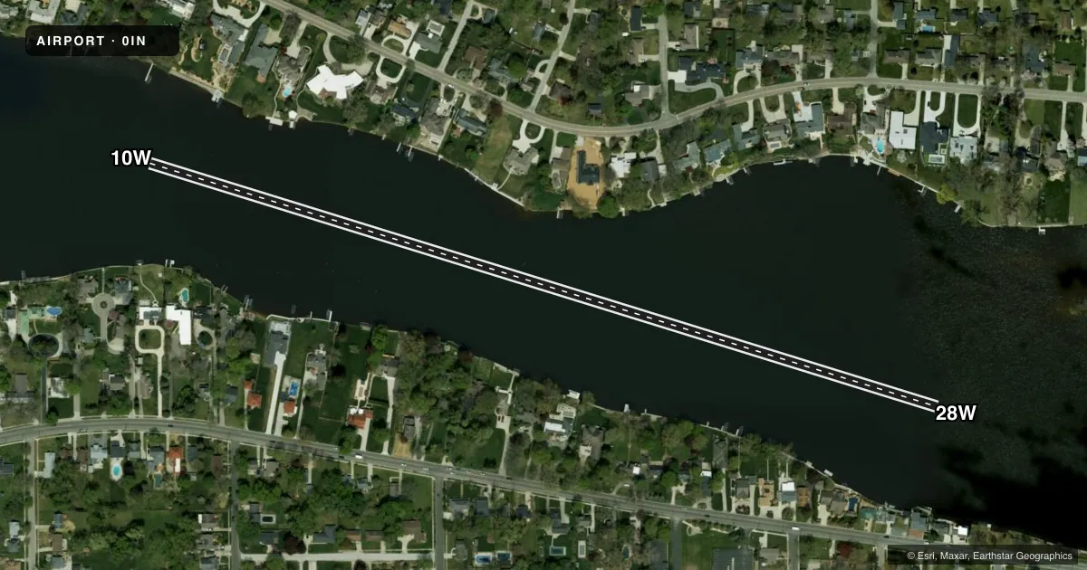
Runways & pattern
Full pagePattern entry · RWY 10W
LEFT TRAFFICAirport sketch
Runways drawn to scale from FAA survey coordinates, rendered over satellite imagery. Not for navigation.
Approaches & charts
Services on the field
Fuel grades, oxygen, maintenance, ramp storage and lighting — as declared to the FAA by the airport operator.
Fuel & services
- Fuel
- Not available
Ramp & ground
- Transient storage
- Not published
Fuel & FBOs
Cheapest 100LL and Jet A on the field and nearby. Always confirm with the FBO before taxi.
Airport notes
Surface conditions, obstructions, local procedures, lighting outages and other notes published with each FAA cycle.
General notes
- SEAPLANE OPS PROHIBITED BTN SS-SR. EXP HVY BOAT TFC BTN MEMORIAL DAY AND LABOR DAY. DO NOT BLOCK BOAT RAMPS. SEAPLANE DOCKING AREAS LTD.
Runway surface & condition
- 10W/28WDEP CTC KEKM ATCT 119.5 BFR TURNING NBND.
Other notes
- MANAGERBOATING LAW ADMIR.
VFR map & nearby airports
VFR sectional. Tap any ICAO chip to open that airport.
Key facts · 0IN
Answer card- ICAO
- 0IN
- Name
- ST JOSEPH RIVER
- Location
- ELKHART, INDIANA
- Elevation
- 750 ft MSL
- Traffic pattern altitude
- 1,750 ft MSL (1,000 AGL)
- Control tower
- Non-towered (use CTAF)
- Total runways
- 1
- Longest runway
- 10W/28W · 2,675 ft
- Published ILS approaches
- 0
- Published frequencies
- 1
- Magnetic variation
- –
- Current flight rules
- VFR
- Current wind
- 180° at 4 kt
- Favored runway now
- RWY 10W
ST JOSEPH RIVER (0IN) sits in Elkhart, Indiana. Field elevation is 750 ft MSL. The airport has one runway. It is a 2,675 ft water runway, 10W/28W. There is no control tower. CTAF is 122.9. No ILS approaches are published here.
Pattern altitude is not published. Use the standard 1,000 ft AGL for light piston operations unless the current Chart Supplement says otherwise. That puts the pattern at 1,750 ft MSL based on the listed field elevation. Seaplane operations are prohibited between sunset and sunrise. Expect heavy boat traffic from Memorial Day through Labor Day. Do not block boat ramps. Docking areas are limited.
Before turning northbound after departure, contact KEKM air traffic control on 119.5. That is a local operating note worth having ready before you launch. There are no on-field FBOs listed. Plan ahead for support and verify current services with the airport operator or the field directly before arrival. This is a water runway environment. Boat traffic, docking space and departure coordination matter more here than pavement length or runway lighting.