METAR & TAF KSMD
Current METAR
Observed 14:55Z
KSMD 271455Z AUTO 00000KT 7SM CLR 24/24 A2993 RMK A01
- Wind
- 000° @ 0 kt
- Visibility
- 7 SM
- Temp / Dew
- 24°C / 24°C
- Altimeter
- 29.93 inHg
- Clouds
- CLR
- Density alt
- 2,104 ft
- Ceiling
- Unlimited
- Rules
- VFR
Airport info & contacts
Manager on record, flight service, ARTCC, attendance schedule and pattern altitude — published by the FAA and refreshed every 28 days.
Location
- From city
- 4 NM N
- VFR sectional
- CHICAGO
- ARTCC
- ZAU · CHICAGO
- NOTAM facility
- HUF (NOTAM-D)
Airport manager
- Name
- SCOTT D. HINDERMAN, A.A.E.
- Phone
- 260-747-4146
- Address
- 3801 WEST FERGUSON ROAD, STE. 209, FORT WAYNE IN 46809
Flight service · Hours
- FSS HUF
- TERRE HAUTE1-800-WX-BRIEF
- Attendance
- 5 NOV-9 MAR · 0700-1900
- 10 MAR-4 NOV · 0700-2100
Frequencies
Tap any row to copy the frequency to your clipboard.
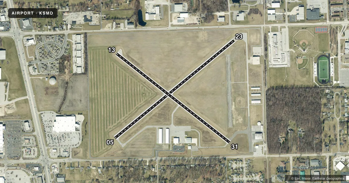
Runways & pattern
Full pagePattern entry · RWY 05
LEFT TRAFFIC| Runway | Heading (°M) | Length | Surface | Traffic |
|---|---|---|---|---|
| 05/23 | 46° / 226° | 3,126 ft | ASPH | Standard L |
| 13/31 | 123° / 303° | 2,922 ft | ASPH | Standard L |
Runway end performance
| End | TORA | TODA | ASDA | LDA | VGSI | Approach lights | Obstruction |
|---|---|---|---|---|---|---|---|
| 05 | — | — | — | — | PAPI 2-box left(4°) | — | 10', crops, 200' from thr, 0' R of cntrln, slope 0 |
| 23 | — | — | — | — | PAPI 2-box left(3.05°) | — | 15', road, 200' from thr, 175' R of cntrln, slope 0 |
| 13 | — | — | — | — | — | — | 60', tree, 1171' from thr, 270' R of cntrln, slope 16 |
| 31 | — | — | — | — | — | — | 15', road, 200' from thr, 200' R of cntrln, slope 0 |
Declared distances in feet. TORA = takeoff run available, TODA = takeoff distance, ASDA = accelerate-stop, LDA = landing distance.
Airport sketch
Runways drawn to scale from FAA survey coordinates, rendered over satellite imagery. Not for navigation.
Approaches & charts
Services on the field
Fuel grades, oxygen, maintenance, ramp storage and lighting — as declared to the FAA by the airport operator.
Fuel & services
- Fuel
- 100LLA
- Airframe repair
- Major
- Power plant repair
- Major
- Other services
- INSTR,RNTL
Ramp & ground
- Transient storage
- Tie-down
- Landing fee
- No fee published
- Customs
- Not available
- Lighting schedule
- SEE RMK
- Beacon schedule
- SS-SR
- Beacon
- White / Green (civil land)(WG)
- Wind indicator
- Lighted
- Segmented circle
- No
Fuel & FBOs
Cheapest 100LL and Jet A on the field and nearby. Always confirm with the FBO before taxi.
Airport notes
Surface conditions, obstructions, local procedures, lighting outages and other notes published with each FAA cycle.
General notes
- 100 FT FLD LGTS 0.5 NM E.
- BIRDS ON & INVOF ARPT.
- FOR CD CTC CHICAGO ARTCC AT 630-906-8921.
- COND UNMNT NOV-MAR 1900-0700.
- COLD TEMPERATURE AIRPORT. ALTITUDE CORRECTION REQUIRED AT OR BELOW -21C.
Lighting notes
- ACTVT PAPI RWY 05; MIRL RWY 05/23 & 13/31 - CTAF.
Fuel notes
- 100LLSELF SVC AVBL.
Runway surface & condition
- 05/23RWY 23 CALM WIND RWY.
- 13/3175 FT CROPS EACH SIDE OF CNTRLN.
Approach & departure obstructions
- 0510 FT CROPS 65 FT FM RWY END & 90 FT E & 115 FT W.
- 1310 FT CROPS 60 FT FM RWY END
- 2315 FT ROAD 185 FT FM RWY END 175 FT R.
- 3115 FT ROAD 215 FT FM RWY END 185 FT L.
- 05PAPI RSTRD BYD 7 DEGS LEFT & RIGHT OF CNTRLN.
- 23PAPI UNUSBL BYD 7 DEGS LEFT & RIGHT OF CNTRLN.
- 13APCH RATIO 24:1 AT DTHR.
Other notes
- EXISTED PRIOR TO 1959.
- 1AFT HR - 260-747-2624.
VFR map & nearby airports
VFR sectional. Tap any ICAO chip to open that airport.
Key facts · KSMD
Answer card- ICAO
- KSMD
- Name
- SMITH FLD
- Location
- FORT WAYNE, INDIANA
- Elevation
- 835.7 ft MSL
- Traffic pattern altitude
- 1,835.7 ft MSL (1,000 AGL)
- Control tower
- Non-towered (use CTAF)
- Total runways
- 2
- Longest runway
- 05/23 · 3,126 ft
- Published ILS approaches
- 0
- Published frequencies
- 7
- Magnetic variation
- 5°
- Current flight rules
- VFR
- Current wind
- 000° at 0 kt
- Favored runway now
- –
Smith Fld sits in Fort Wayne, Indiana. Field elevation is 835.7 ft MSL. The airport has two asphalt runways. The longest is 05/23 at 3,126 ft. There is no control tower. Traffic pattern altitude is not published, so use the standard 1,000 ft AGL pattern unless the current Chart Supplement says otherwise.
No ILS approaches are published here. The field is inside the Fort Wayne area and you will be working with Fort Wayne approach and departure frequencies, plus CTAF or UNICOM 122.8 when appropriate. Smith Field Aero Center is on the field. It carries 100LL and Jet A. Call ahead at (260) 489-5518 if you need current service details.
A few published remarks matter for planning. Runway 23 is the calm wind runway. The PAPI on runway 05 is activated by CTAF. The medium intensity runway lights on 05/23 and 13/31 are also CTAF-activated. The airport is a cold temperature airport. Altitude correction is required at or below minus 21 degrees Celsius. Birds are reported on and near the airport. There are also crops 75 feet from the centerline on runway 13/31. For a first-time arrival, pay attention to the published obstacle notes and use the current Chart Supplement for any clearance or operational details before you go.