METAR & TAF IN4
IN4 does not publish a METAR.
Showing the nearest reporting station: KGWB (AUBURN/DEKALB EXEC) · 6.5 NM away. Conditions at IN4 may differ.
METAR · KGWB
Observed 10:35Z
KGWB 251035Z AUTO 00000KT 10SM CLR 13/13 A3007 RMK AO2
- Wind
- 000° @ 0 kt
- Visibility
- 10 SM
- Temp / Dew
- 13°C / 13°C
- Altimeter
- 30.07 inHg
- Clouds
- CLR
- Density alt
- 542 ft
- Ceiling
- Unlimited
- Rules
- VFR
Airport info & contacts
Manager on record, flight service, ARTCC, attendance schedule and pattern altitude — published by the FAA and refreshed every 28 days.
Location
- From city
- 1 NM SE
- VFR sectional
- CHICAGO
- ARTCC
- ZAU · CHICAGO
- NOTAM facility
- HUF
Airport manager
- Name
- KENTON TURNER
- Phone
- (317) 232-0935
- Address
- 402 W WASHINGTON ST. RM W-255D, INDIANAPOLIS IN 46204
Flight service · Hours
- FSS HUF
- TERRE HAUTE1-800-WX-BRIEF
Frequencies
Tap any row to copy the frequency to your clipboard.
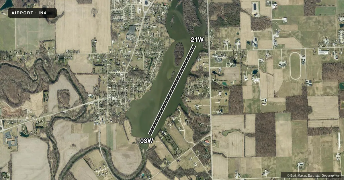
Runways & pattern
Full pagePattern entry · RWY 03W
LEFT TRAFFICAirport sketch
Runways drawn to scale from FAA survey coordinates, rendered over satellite imagery. Not for navigation.
Approaches & charts
Services on the field
Fuel grades, oxygen, maintenance, ramp storage and lighting — as declared to the FAA by the airport operator.
Fuel & services
- Fuel
- Not available
Ramp & ground
- Transient storage
- Not published
Fuel & FBOs
Cheapest 100LL and Jet A on the field and nearby. Always confirm with the FBO before taxi.
Airport notes
Surface conditions, obstructions, local procedures, lighting outages and other notes published with each FAA cycle.
VFR map & nearby airports
VFR sectional. Tap any ICAO chip to open that airport.
Key facts · IN4
Answer card- ICAO
- IN4
- Name
- CEDARVILLE RESERVOIR
- Location
- LEO-CEDARVILLE, INDIANA
- Elevation
- 781 ft MSL
- Traffic pattern altitude
- 1,781 ft MSL (1,000 AGL)
- Control tower
- Non-towered (use CTAF)
- Total runways
- 1
- Longest runway
- 03W/21W · 4,141 ft
- Published ILS approaches
- 0
- Published frequencies
- 1
- Magnetic variation
- –
- Current flight rules
- VFR
- Current wind
- 000° at 0 kt
- Favored runway now
- –
Cedarville Reservoir (IN4) sits in Leo-Cedarville, Indiana. Field elevation is 781 ft MSL. The airport has one runway. It is a 4,141 ft water runway, 03W/21W. There is no control tower. CTAF is 122.9.
No ILS approaches are published here. Pattern altitude is not published in the facts. Use the standard 1,000 ft AGL for light piston operations unless the current FAA Chart Supplement says otherwise. The runway headings are listed as magnetic in the airport data. That matters on a water strip where wind, current and local traffic flow can change the picture fast.
There are no on-field FBOs listed. Plan ahead for services before arrival. If you need current fuel or ramp details, call the airport operator or the field directly by phone. No published remarks are listed for this airport.
For a first-time arrival, the key items are simple. This is an uncontrolled water runway with no published ILS. Review the current Chart Supplement before departure. Check the sectional or TAC for airspace, nearby terrain and any local traffic considerations. Keep your scan tight on the water. Make your CTAF calls early.