METAR & TAF C62
Current METAR
Observed 05:35Z
KC62 270535Z AUTO 00000KT 4SM BR CLR 20/20 A2990 RMK AO2 T02010201
- Wind
- 000° @ 0 kt
- Visibility
- 4 SM
- Temp / Dew
- 20°C / 20°C
- Altimeter
- 29.90 inHg
- Clouds
- CLR
- Density alt
- 1,870 ft
- Ceiling
- Unlimited
- Rules
- MVFR
Airport info & contacts
Manager on record, flight service, ARTCC, attendance schedule and pattern altitude — published by the FAA and refreshed every 28 days.
Location
- From city
- 2 NM N
- VFR sectional
- CHICAGO
- ARTCC
- ZAU · CHICAGO
- NOTAM facility
- HUF (NOTAM-D)
Airport manager
- Name
- JOHN KLINE
- Phone
- 260-349-0350
- Address
- 363 E. AIRPORT RD., KENDALLVILLE IN 46755
Flight service · Hours
- FSS HUF
- TERRE HAUTE1-800-WX-BRIEF
- Attendance
- MON - SAT · 0800-1700
- SUN · 1200-1700
Frequencies
Tap any row to copy the frequency to your clipboard.
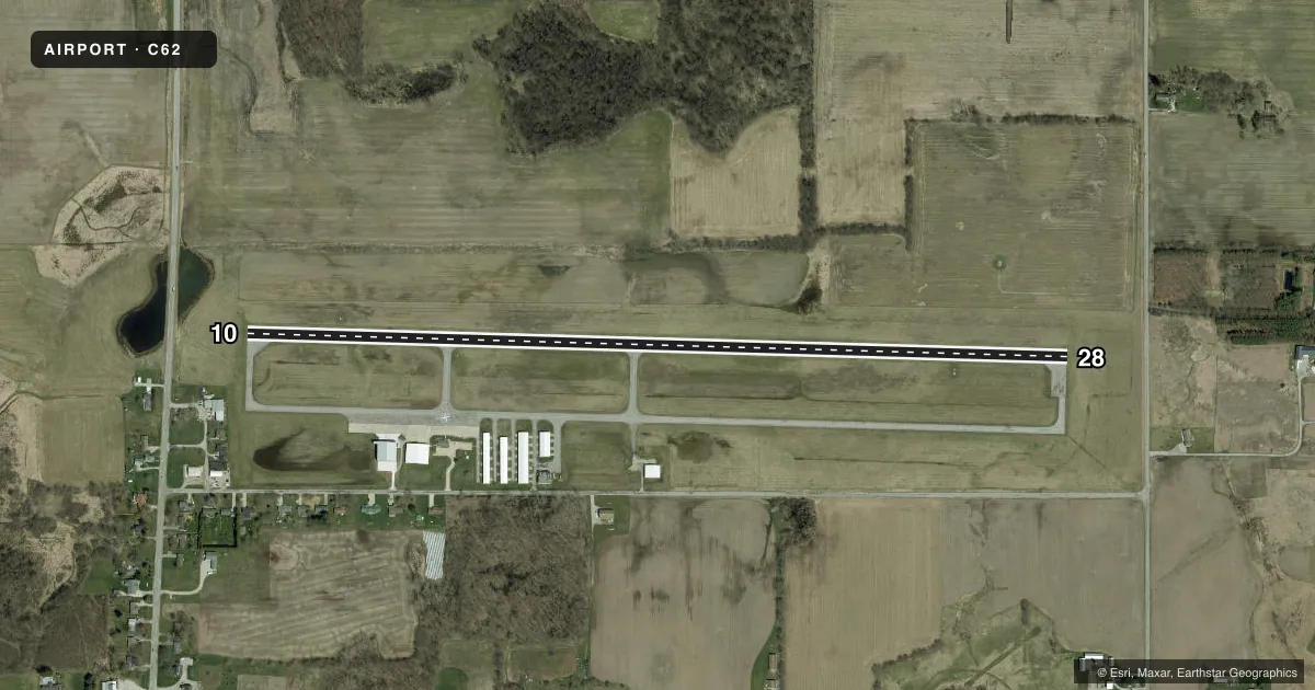
Runways & pattern
Full pagePattern entry · RWY 10
LEFT TRAFFICRunway end performance
| End | TORA | TODA | ASDA | LDA | VGSI | Approach lights | Obstruction |
|---|---|---|---|---|---|---|---|
| 10 | — | — | — | — | PAPI 2-box left(3.5°) | — | 40', trees, 945' from thr, 250' R of cntrln, slope 18 |
| 28 | — | — | — | — | PAPI 2-box left(3.5°) | — | 40', trees, 990' from thr, 140' R of cntrln, slope 19 |
Declared distances in feet. TORA = takeoff run available, TODA = takeoff distance, ASDA = accelerate-stop, LDA = landing distance.
Airport sketch
Runways drawn to scale from FAA survey coordinates, rendered over satellite imagery. Not for navigation.
Approaches & charts
Services on the field
Fuel grades, oxygen, maintenance, ramp storage and lighting — as declared to the FAA by the airport operator.
Fuel & services
- Fuel
- 100LLA
- Airframe repair
- Minor
- Power plant repair
- Minor
- Other services
- AGRI,INSTR,RNTL,TOW
Ramp & ground
- Transient storage
- Tie-down
- Hangar
- Landing fee
- No fee published
- Customs
- Not available
- Lighting schedule
- SEE RMK
- Beacon schedule
- SS-SR
- Beacon
- White / Green (civil land)(WG)
- Wind indicator
- Lighted
- Segmented circle
- Yes
Fuel & FBOs
Cheapest 100LL and Jet A on the field and nearby. Always confirm with the FBO before taxi.
Airport notes
Surface conditions, obstructions, local procedures, lighting outages and other notes published with each FAA cycle.
General notes
- GLIDER OPS MAY-NOV 0900-SS.
- FOR CD CTC CHICAGO ARTCC AT 630-906-8921.
Lighting notes
- ACTVT REIL RWY 10 & 28; PAPI RWY 10 & 28; MIRL RWY 10/28 - CTAF.
Runway surface & condition
- 10/28160 FT CROPS N OF CNTRLN ENTIRE LEN.
Approach & departure obstructions
- 105 FT TRRN DOWN SLOPE 100 FT FM RWY END.
- 28UNUSBL BYD 9 DEGS RIGHT OF CNTRLN.
Other notes
- 2EMERG - 574-276-3933.
VFR map & nearby airports
VFR sectional. Tap any ICAO chip to open that airport.
Key facts · C62
Answer card- ICAO
- C62
- Name
- KENDALLVILLE MUNI
- Location
- KENDALLVILLE, INDIANA
- Elevation
- 1,004.3 ft MSL
- Traffic pattern altitude
- 2,004.3 ft MSL (1,000 AGL)
- Control tower
- Non-towered (use CTAF)
- Total runways
- 1
- Longest runway
- 10/28 · 4,400 ft
- Published ILS approaches
- 0
- Published frequencies
- 7
- Magnetic variation
- 4°
- Current flight rules
- MVFR
- Current wind
- 000° at 0 kt
- Favored runway now
- –
Kendallville Muni sits in Kendallville, Indiana. Field elevation is 1,004.3 ft MSL. The airport has one runway. Runway 10/28 is 4,400 ft of asphalt. There is no control tower. No ILS approaches are published here. The pattern altitude is not published, so use the standard 1,000 ft AGL for light piston traffic unless the current FAA Chart Supplement says otherwise.
Falcon Aviation is on the field. It carries 100LL and Jet A. The published remarks also matter for a first visit. There are 160-foot crops north of the runway centerline along the full length of 10/28. Runway 28 is unusable beyond 9 degrees right of centerline. Runway end identifier lights are installed on 10 and 28. PAPI is also installed on both ends. Medium intensity runway lights are activated by CTAF.
This is a non-towered field with local traffic and glider activity from May through November between 0900 and sunset. Plan your arrival with that in mind. The airport uses Fort Wayne approach frequencies for IFR coordination. For clearance delivery, contact Chicago Center at the published number before departure if needed. If you need current noise or operating restrictions, check the current FAA Chart Supplement before flying in.