METAR & TAF KANQ
Current METAR
Observed 14:55Z
KANQ 271455Z AUTO 24006KT 5SM BR CLR 23/23 A2991 RMK AO2 P0001
- Wind
- 240° @ 6 kt
- Visibility
- 5 SM
- Temp / Dew
- 23°C / 23°C
- Altimeter
- 29.91 inHg
- Clouds
- CLR
- Density alt
- 2,206 ft
- Ceiling
- Unlimited
- Rules
- MVFR
Airport info & contacts
Manager on record, flight service, ARTCC, attendance schedule and pattern altitude — published by the FAA and refreshed every 28 days.
Location
- From city
- 3 NM W
- VFR sectional
- CHICAGO
- ARTCC
- ZAU · CHICAGO
- NOTAM facility
- HUF (NOTAM-D)
Airport manager
- Name
- TERRY HALLETT
- Phone
- 260-316-3711
- Address
- 5220 W. U.S. 20, ANGOLA IN 46703-9680
Flight service · Hours
- FSS HUF
- TERRE HAUTE1-800-WX-BRIEF
- Attendance
- MAR-NOV · MON-SAT · 0800-1700
- MAR-NOV · SUN · 1200-1700
- DEC-FEB · MON-FRI · 0800-1700
Frequencies
Tap any row to copy the frequency to your clipboard.
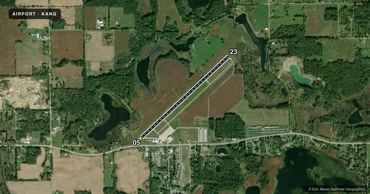
Runways & pattern
Full pagePattern entry · RWY 23
LEFT TRAFFICRunway end performance
| End | TORA | TODA | ASDA | LDA | VGSI | Approach lights | Obstruction |
|---|---|---|---|---|---|---|---|
| 05 | 4,540' | 4,540' | 4,540' | 4,000' | PAPI 2-box left(3°) | — | 15', road, 200' from thr, 205' R of cntrln, slope 0 |
| 23 | 4,000' | 4,000' | 4,000' | 4,000' | PAPI 2-box left(4°) | — | 73', trees, 860' from thr, 280' R of cntrln, slope 9 |
Declared distances in feet. TORA = takeoff run available, TODA = takeoff distance, ASDA = accelerate-stop, LDA = landing distance.
Airport sketch
Runways drawn to scale from FAA survey coordinates, rendered over satellite imagery. Not for navigation.
Approaches & charts
Services on the field
Fuel grades, oxygen, maintenance, ramp storage and lighting — as declared to the FAA by the airport operator.
Fuel & services
- Fuel
- 100LLA
- Other services
- AGRI,PAJA
Ramp & ground
- Transient storage
- Tie-down
- Hangar
- Landing fee
- No fee published
- Customs
- Not available
- Lighting schedule
- SEE RMK
- Beacon schedule
- SS-SR
- Beacon
- White / Green (civil land)(WG)
- Wind indicator
- Lighted
- Segmented circle
- No
Fuel & FBOs
Cheapest 100LL and Jet A on the field and nearby. Always confirm with the FBO before taxi.
Airport notes
Surface conditions, obstructions, local procedures, lighting outages and other notes published with each FAA cycle.
General notes
- PAJA & BIRDS ON & INVOF ARPT; DEER SS-SR.
- COND UNMNT 1700-0800, WKEND & HOL.
- FOR CD CTC CHICAGO ARTCC AT 630-906-8921.
Lighting notes
- ACTVT REIL RWY 05 & 23; MIRL RWY 05/23 - CTAF. DUSK-0000 MIRL RWY 05/23 PRESET LOW INTST; INCR INTST - CTAF.
Runway surface & condition
- 05/23260 FT UNLGTD STWY SW END.
Approach & departure obstructions
- 0515 FT ROAD 200 FT FM RWY END 205 FT R.
- 05APCH SLOPE 34:1 FM DTHR.
Other notes
- 1UNATNDD THANKSGIVING, CHRISTMAS & NEW YEARS.
VFR map & nearby airports
VFR sectional. Tap any ICAO chip to open that airport.
Key facts · KANQ
Answer card- ICAO
- KANQ
- Name
- TRI-STATE STEUBEN COUNTY
- Location
- ANGOLA, INDIANA
- Elevation
- 995 ft MSL
- Traffic pattern altitude
- 1,995 ft MSL (1,000 AGL)
- Control tower
- Non-towered (use CTAF)
- Total runways
- 1
- Longest runway
- 05/23 · 4,540 ft
- Published ILS approaches
- 0
- Published frequencies
- 5
- Magnetic variation
- 5°
- Current flight rules
- MVFR
- Current wind
- 240° at 6 kt
- Favored runway now
- RWY 23
Tri-State Steuben County Airport is in Angola, Indiana. The field elevation is 995 ft MSL. It has one runway, 05/23, which is 4,540 ft long. There is no control tower. CTAF and UNICOM are both 123.075. No ILS approaches are published here.
Pattern altitude is not published. Use 1,000 ft AGL for light piston operations unless the current Chart Supplement says otherwise. That puts the pattern at 1,995 ft MSL. The airport sits in northeast Indiana near the Ohio border, so plan for a simple non-towered arrival with normal self-announced traffic calls. Chicago ARTCC handles clearances. Fort Wayne approach and departure frequencies are listed for the area.
Tri-State Steuben County Airport is the on-field FBO. It carries 100LL and Jet A with Prist. Call (260) 665-3212 for current service details. The runway lighting is pilot-controlled on CTAF. Runway end identifier lights are installed on both ends. From dusk to midnight, the medium intensity lights are preset to low. Use CTAF to increase intensity. Published remarks also note deer from sunset to sunrise. Birds and paja are on or near the field. There is a 34:1 approach slope note from the displaced threshold on runway 05. Check the current Chart Supplement for any operational updates before you go.