METAR & TAF IN2
IN2 does not publish a METAR.
Showing the nearest reporting station: KANQ (TRI-STATE STEUBEN COUNTY) · 5.9 NM away. Conditions at IN2 may differ.
METAR · KANQ
Observed 13:35Z
KANQ 271335Z AUTO 24004KT 4SM -RA BR SCT037 SCT060 BKN080 23/23 A2992 RMK AO2
- Wind
- 240° @ 4 kt
- Visibility
- 4 SM
- Temp / Dew
- 23°C / 23°C
- Altimeter
- 29.92 inHg
- Clouds
- BKN
- Density alt
- 2,157 ft
- Ceiling
- 8,000 ft AGL
- Rules
- MVFR
Airport info & contacts
Manager on record, flight service, ARTCC, attendance schedule and pattern altitude — published by the FAA and refreshed every 28 days.
Location
- From city
- 1 NM SE
- VFR sectional
- CHICAGO
- ARTCC
- ZAU · CHICAGO
- NOTAM facility
- HUF (NOTAM-D)
Airport manager
- Name
- BRIAN BAILEY
- Phone
- 317-605-6023
- Address
- 402 W. WASHINGTON ST., RM W-255D, INDIANAPOLIS IN 46204
Flight service · Hours
- FSS HUF
- TERRE HAUTE1-800-WX-BRIEF
Frequencies
Tap any row to copy the frequency to your clipboard.
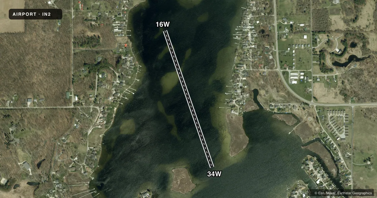
Runways & pattern
Full pagePattern entry · RWY 16W
LEFT TRAFFICAirport sketch
Runways drawn to scale from FAA survey coordinates, rendered over satellite imagery. Not for navigation.
Approaches & charts
Services on the field
Fuel grades, oxygen, maintenance, ramp storage and lighting — as declared to the FAA by the airport operator.
Fuel & services
- Fuel
- Not available
Ramp & ground
- Transient storage
- Not published
Fuel & FBOs
Cheapest 100LL and Jet A on the field and nearby. Always confirm with the FBO before taxi.
Airport notes
Surface conditions, obstructions, local procedures, lighting outages and other notes published with each FAA cycle.
General notes
- SEAPLANE OPS PROHIBITED BTN SS-SR. EXP HVY BOAT TFC BTN MEMORIAL DAY AND LABOR DAY. DO NOT BLOCK BOAT RAMPS. SEAPLANE DOCKING AREAS LTD.
Other notes
- MANAGERBOATING LAW ADMIR.
VFR map & nearby airports
VFR sectional. Tap any ICAO chip to open that airport.
Key facts · IN2
Answer card- ICAO
- IN2
- Name
- SNOW LAKE
- Location
- JAMESTOWN, INDIANA
- Elevation
- 965 ft MSL
- Traffic pattern altitude
- 1,965 ft MSL (1,000 AGL)
- Control tower
- Non-towered (use CTAF)
- Total runways
- 1
- Longest runway
- 16W/34W · 2,675 ft
- Published ILS approaches
- 0
- Published frequencies
- 1
- Magnetic variation
- –
- Current flight rules
- MVFR
- Current wind
- 240° at 4 kt
- Favored runway now
- RWY 16W
Snow Lake (IN2) sits in Jamestown, Indiana at 965 ft MSL. It is a water airport with one runway. The marked water runway is 16W/34W at 2,675 ft. That is the longest available landing area on the field. There is no control tower. CTAF is 122.9.
No ILS approaches are published here. Pattern altitude is not published, so use the standard 1,000 ft AGL pattern unless the current FAA Chart Supplement says otherwise. At this elevation, that puts the light aircraft pattern near 1,965 ft MSL. Magnetic variation is not listed in the facts, so verify runway alignment and local traffic procedures before arrival if you need exact heading references.
There are no on-field FBOs listed. Check with the airport operator or the FBO directly by phone for current services before you go. The published remarks matter here. Seaplane operations are prohibited from sunset to sunrise. Expect heavy boat traffic from Memorial Day through Labor Day. Do not block boat ramps. Docking areas are limited. That makes low, slow and predictable traffic pattern work important, especially on busy summer days.