METAR & TAF KRMY
Current METAR
Observed 18:35Z
KRMY 261835Z AUTO 27008KT 10SM BKN030 BKN040 BKN048 28/21 A2991 RMK AO2
- Wind
- 270° @ 8 kt
- Visibility
- 10 SM
- Temp / Dew
- 28°C / 21°C
- Altimeter
- 29.91 inHg
- Clouds
- BKN
- Density alt
- 2,739 ft
- Ceiling
- 3,000 ft AGL
- Rules
- MVFR
Airport info & contacts
Manager on record, flight service, ARTCC, attendance schedule and pattern altitude — published by the FAA and refreshed every 28 days.
Location
- From city
- 1 NM S
- VFR sectional
- DETROIT
- Pattern altitude
- 1,000 ft AGL · 1,941 ft MSL
- ARTCC
- ZAU · CHICAGO
- NOTAM facility
- RMY (NOTAM-D)
Airport manager
- Name
- CRAIG GRISWOLD
- Phone
- 269-330-2908
- Address
- TOWN HALL, 323 W MICHIGAN AVE, MARSHALL MI 49068-1547
Flight service · Hours
- FSS LAN
- LANSING1-800-WX-BRIEF
- Attendance
- 0800-DUSK
Frequencies
Tap any row to copy the frequency to your clipboard.
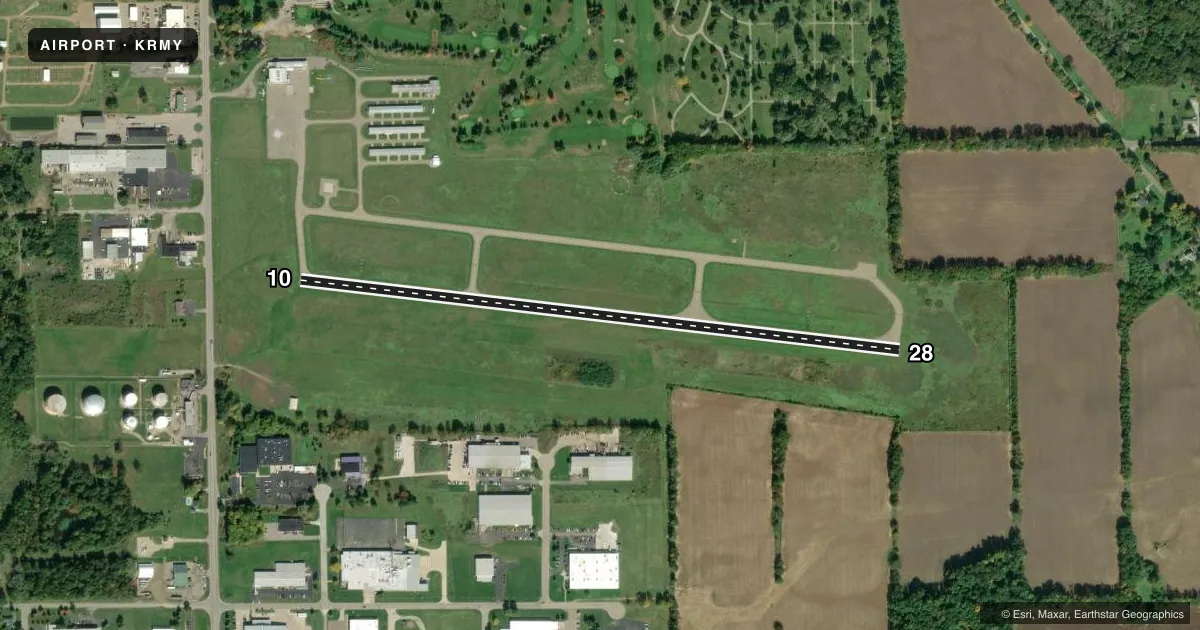
Runways & pattern
Full pagePattern entry · RWY 28
LEFT TRAFFICRunway end performance
| End | TORA | TODA | ASDA | LDA | VGSI | Approach lights | Obstruction |
|---|---|---|---|---|---|---|---|
| 10 | — | — | — | — | PAPI 4-box left(4°) | — | — |
| 28 | — | — | — | — | PAPI 4-box right(4°) | — | 40', trees, 640' from thr, 217' R of cntrln, slope 11 |
Declared distances in feet. TORA = takeoff run available, TODA = takeoff distance, ASDA = accelerate-stop, LDA = landing distance.
Airport sketch
Runways drawn to scale from FAA survey coordinates, rendered over satellite imagery. Not for navigation.
Approaches & charts
Services on the field
Fuel grades, oxygen, maintenance, ramp storage and lighting — as declared to the FAA by the airport operator.
Fuel & services
- Fuel
- 100LLUL94
- Airframe repair
- Major
- Power plant repair
- Major
- Other services
- GLD,INSTR,TOW
Ramp & ground
- Transient storage
- Tie-down
- Hangar
- Landing fee
- No fee published
- Customs
- Not available
- Lighting schedule
- SEE RMK
- Beacon schedule
- SS-SR
- Beacon
- White / Green (civil land)(WG)
- Wind indicator
- Lighted
- Segmented circle
- Yes
Fuel & FBOs
Cheapest 100LL and Jet A on the field and nearby. Always confirm with the FBO before taxi.
Airport notes
Surface conditions, obstructions, local procedures, lighting outages and other notes published with each FAA cycle.
General notes
- DEER & LRG BIRDS ON & INVOF ARPT.
- GLIDER & ULTRALIGHT ACTVTY ON & INVOF ARPT, SUMMER MOS.
- ULTRALIGHT ACFT FLY LEFT HAND PATTERN 500 FT AGL, S OF RY 10/28.
- 150 FT LGTD WATER TWR 3000 FT S OF HELIPAD.
- ADMIN BLDG ACES, PRESS 5-3-2-1.
- FOR CD CTC GREAT LAKES APCH AT 269-459-3344, WHEN APCH CLSD CTC CHICAGO ARTCC AT 630-906-8921.
- FOR SNOW REMOVAL HELIPAD H1 CALL AMGR.
Lighting notes
- ACTVT PAPI RWY 10 & 28; MIRL RWY 10/28; NSTD PERIMETER LGTS HELIPAD H1 - CTAF.
Runway surface & condition
- H1NSTD PERIMETER LGTS DUE TO COLOR.
Approach & departure obstructions
- 10ALSO +15 FT ROAD, 520 FT DIST, 0 FT B, APCH RATIO 21:1.
- H124 FT WINDSOCK ON POLE, 195 FT NE.
Other notes
- 1EXC MAJOR HOLS.
VFR map & nearby airports
VFR sectional. Tap any ICAO chip to open that airport.
Key facts · KRMY
Answer card- ICAO
- KRMY
- Name
- BROOKS FLD
- Location
- MARSHALL, MICHIGAN
- Elevation
- 941.2 ft MSL
- Traffic pattern altitude
- 1,941.2 ft MSL (1,000 AGL)
- Control tower
- Non-towered (use CTAF)
- Total runways
- 1
- Longest runway
- 10/28 · 3,501 ft
- Published ILS approaches
- 0
- Published frequencies
- 4
- Magnetic variation
- 5°
- Current flight rules
- MVFR
- Current wind
- 270° at 8 kt
- Favored runway now
- RWY 28
Brooks Fld is in Marshall, Michigan. The field elevation is 941.2 ft MSL. It has one runway, 10/28, which is 3,501 ft long. There is no control tower. Pattern altitude is 1,000 ft AGL, which is 1,941.2 ft MSL.
No ILS approaches are published here. For clearance delivery, contact Great Lakes Approach. When Approach is closed, contact Chicago ARTCC. The airport uses CTAF 122.8 and UNICOM 122.8. Brooks Field is the on-field FBO. It carries AVGAS 100LL and UL94.
First-time pilots should pay attention to the summer glider and ultralight activity. Ultralights use a left-hand pattern 500 ft AGL south of runway 10/28. Deer and large birds are also reported on and near the airport. The published remarks also note nonstandard perimeter lights due to color. Runway 10 and 28 have PAPI and medium intensity runway lights. There is also a 24 ft windsock on a pole 195 ft northeast. Check the current FAA Chart Supplement for any current operational notes before you go.