METAR & TAF 49G
49G does not publish a METAR.
Showing the nearest reporting station: KFPK (FITCH H BEACH) · 4.3 NM away. Conditions at 49G may differ.
METAR · KFPK
Observed 12:55Z
KFPK 271255Z AUTO 22007KT 6SM BR OVC005 24/23 A2984 RMK AO2
- Wind
- 220° @ 7 kt
- Visibility
- 6 SM
- Temp / Dew
- 24°C / 23°C
- Altimeter
- 29.84 inHg
- Clouds
- OVC
- Density alt
- 2,244 ft
- Ceiling
- 500 ft AGL
- Rules
- IFR
Airport info & contacts
Manager on record, flight service, ARTCC, attendance schedule and pattern altitude — published by the FAA and refreshed every 28 days.
Location
- From city
- 3 NM NW
- VFR sectional
- DETROIT
- ARTCC
- ZOB · CLEVELAND
- NOTAM facility
- LAN (NOTAM-D)
Airport manager
- Name
- ROGER WEND
- Phone
- 517-819-4856
- Address
- 3711 VALLEY HWY, CHARLOTTE MI 48813-8877
Flight service · Hours
- FSS LAN
- LANSING1-800-WX-BRIEF
- Attendance
- IREG
Frequencies
Tap any row to copy the frequency to your clipboard.
Runways & pattern
Full pagePattern entry · RWY 18
LEFT TRAFFICRunway end performance
| End | TORA | TODA | ASDA | LDA | VGSI | Approach lights | Obstruction |
|---|---|---|---|---|---|---|---|
| 18 | — | — | — | — | — | — | 81', trees, 1030' from thr, 0' R of cntrln, slope 12 |
Declared distances in feet. TORA = takeoff run available, TODA = takeoff distance, ASDA = accelerate-stop, LDA = landing distance.
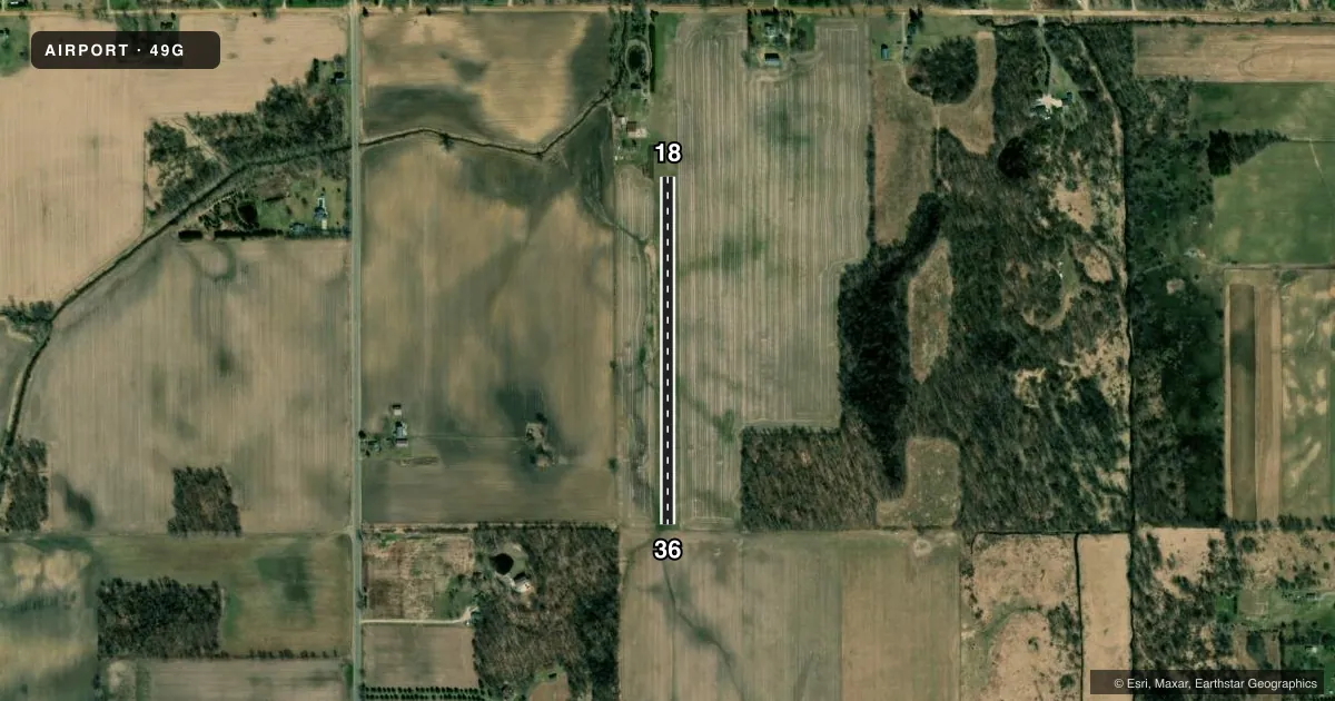
Airport sketch
Runways drawn to scale from FAA survey coordinates, rendered over satellite imagery. Not for navigation.
Approaches & charts
Services on the field
Fuel grades, oxygen, maintenance, ramp storage and lighting — as declared to the FAA by the airport operator.
Fuel & services
- Fuel
- Not available
Ramp & ground
- Transient storage
- Tie-down
- Landing fee
- No fee published
- Customs
- Not available
- Wind indicator
- Yes
- Segmented circle
- No
Fuel & FBOs
Cheapest 100LL and Jet A on the field and nearby. Always confirm with the FBO before taxi.
Airport notes
Surface conditions, obstructions, local procedures, lighting outages and other notes published with each FAA cycle.
General notes
- NO SNOW REMOVAL ON RY 18/36.
- ARPT CLSD DEC-MAR AND WHEN SNOW COVERED.
- FOR CD CTC GREAT LAKES APCH AT 269-459-3345, WHEN APCH CLSD CTC CLEVELAND ARTCC AT 440-774-0224/0490.
Approach & departure obstructions
- 18RY 18/36 & RY 36 DSPLCD THR MKD WITH 3 FT YELLOW CONES.
- 18APCH RATIO 20:1 FM DSPLCD THR OVR 79' TREES, 1630' DSTC, 0' B.
VFR map & nearby airports
VFR sectional. Tap any ICAO chip to open that airport.
Key facts · 49G
Answer card- ICAO
- 49G
- Name
- WEND VALLEY
- Location
- CHARLOTTE, MICHIGAN
- Elevation
- 859 ft MSL
- Traffic pattern altitude
- 1,859 ft MSL (1,000 AGL)
- Control tower
- Non-towered (use CTAF)
- Total runways
- 1
- Longest runway
- 18/36 · 1,800 ft
- Published ILS approaches
- 0
- Published frequencies
- 1
- Magnetic variation
- 4°
- Current flight rules
- IFR
- Current wind
- 220° at 7 kt
- Favored runway now
- RWY 18
WEND VALLEY (49G) is in Charlotte, Michigan. Field elevation is 859 ft MSL. The airport has one runway. Runway 18/36 is 1,800 ft of turf, which makes this a short-field stop for light aircraft only. No control tower is listed. CTAF is 122.9.
No ILS approaches are published here. The pattern altitude is not published in the facts, so use the standard 1,000 ft AGL for light piston operations unless the current Chart Supplement says otherwise. The published remarks matter here. Runway 18/36 and the displaced threshold on runway 36 are marked with 3-foot yellow cones. There is also a published obstacle note for the 18 approach. It calls out 79-foot trees 1,630 ft from the displaced threshold. Plan your approach path with that in mind.
There are no on-field FBOs listed. Check with the airport operator or the field directly before you go if you need local services. The airport is closed December through March. It is also closed when snow covered. There is no snow removal on runway 18/36. For clearance delivery, the published contact is Great Lakes Approach. When approach is closed, contact Cleveland ARTCC.