METAR & TAF 4D0
4D0 does not publish a METAR.
Showing the nearest reporting station: KLAN (CAPITAL REGION INTL) · 6.5 NM away. Conditions at 4D0 may differ.
METAR · KLAN
Observed 05:53Z
KLAN 270553Z 25003KT 8SM CLR 23/21 A2986 RMK AO2 SLP104 T02280211 10283 20228 55005 $
- Wind
- 250° @ 3 kt
- Visibility
- 8 SM
- Temp / Dew
- 23°C / 21°C
- Altimeter
- 29.86 inHg
- Clouds
- CLR
- Density alt
- 2,077 ft
- Ceiling
- Unlimited
- Rules
- VFR
Airport info & contacts
Manager on record, flight service, ARTCC, attendance schedule and pattern altitude — published by the FAA and refreshed every 28 days.
Location
- From city
- 2 NM N
- VFR sectional
- DETROIT
- ARTCC
- ZOB · CLEVELAND
- NOTAM facility
- LAN (NOTAM-D)
Airport manager
- Name
- AMEE KING, ASST CITY MGR
- Phone
- 517-622-7925
- Address
- 310 GREENWOOD ST, GRAND LEDGE MI 48837-1651
Flight service · Hours
- FSS LAN
- LANSING1-800-WX-BRIEF
- Attendance
- MON&FRI · 0800-1630
- TUE-THU · 0800-0000
Frequencies
Tap any row to copy the frequency to your clipboard.
Runways & pattern
Full pagePattern entry · RWY 27
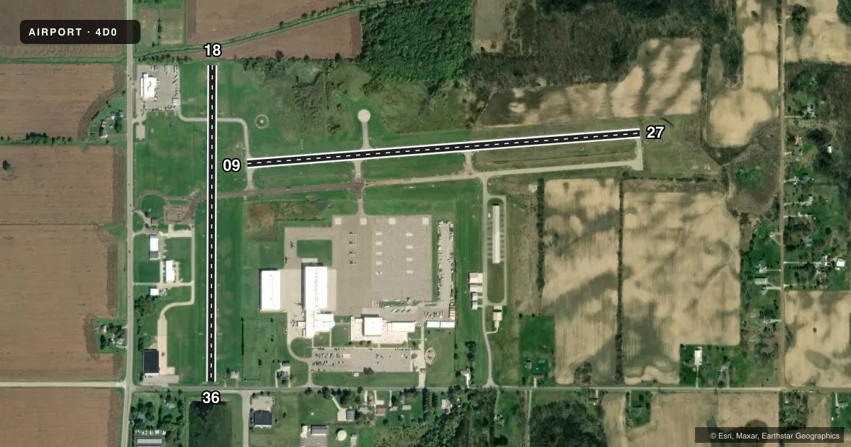
LEFT TRAFFIC| Runway | Heading (°M) | Length | Surface | Traffic |
|---|---|---|---|---|
| 09/27Favored | 81° / 261° | 3,200 ft | ASPH | Standard L |
| 18/36 | 175° / 355° | 2,560 ft | TURF | Standard L |
Runway end performance
| End | TORA | TODA | ASDA | LDA | VGSI | Approach lights | Obstruction |
|---|---|---|---|---|---|---|---|
| 09 | — | — | — | — | PAPI 4-box left(4°) | — | 49', tree, 1003' from thr, 380' R of cntrln, slope 16 |
| 27 | — | — | — | — | PAPI 2-box left(4°) | — | 14', brush, 353' from thr, 204' R of cntrln, slope 10 |
| 18 | — | — | — | — | — | — | 8', trees, 50' from thr, 130' R of cntrln, slope 6 |
| 36 | — | — | — | — | — | — | 17', road, 45' from thr, 0' R of cntrln, slope 2 |
Declared distances in feet. TORA = takeoff run available, TODA = takeoff distance, ASDA = accelerate-stop, LDA = landing distance.
Airport sketch
Runways drawn to scale from FAA survey coordinates, rendered over satellite imagery. Not for navigation.
Approaches & charts
Services on the field
Fuel grades, oxygen, maintenance, ramp storage and lighting — as declared to the FAA by the airport operator.
Fuel & services
- Fuel
- 100LL
- Oxygen (bottled)
- Not available
- Oxygen (bulk)
- Not available
- Airframe repair
- Major
- Power plant repair
- Major
- Other services
- CHTR,INSTR,RNTL
Ramp & ground
- Transient storage
- Tie-down
- Hangar
- Landing fee
- No fee published
- Customs
- Not available
- Lighting schedule
- SEE RMK
- Beacon schedule
- SS-SR
- Beacon
- White / Green (civil land)(WG)
- Wind indicator
- Lighted
- Segmented circle
- Yes
Fuel & FBOs
Cheapest 100LL and Jet A on the field and nearby. Always confirm with the FBO before taxi.
Airport notes
Surface conditions, obstructions, local procedures, lighting outages and other notes published with each FAA cycle.
General notes
- INTSV NG HELICOPTER TRG ON & INVOF ARPT. HELICOPTERS AVOID FLOW OF FIXED WING ACFT PER 14 CFR 91.126.
- AVOID OVERFLIGHT OF GRAND LEDGE BLW 2000 FT.
- MILITARY: RNG: NO FIXED WING & LTD ROTARY WING PRKG ON AASF RAMP.
- CTC AIRFIELD OPS ON 41.85/122.7/241.0.
- FOR CD CTC GREAT LAKES APCH AT 269-459-3345, WHEN APCH CLSD CTC CLEVELAND ARTCC AT 440-774-0224/0490.
- TPA 1900 FT MSL FOR FW; 1700 FT MSL FOR HEL.
- DEER & LRG BIRDS ON & INVOF ARPT.
Lighting notes
- ACTVT REIL RWY 27; PAPI RWY 09 & 27; MIRL RWY 09/27 - CTAF.
Approach & departure obstructions
- 274 FT HILL, 30-199 FT DIST, 125-250 FT L.
- 09UNUSBL BYD 5 DEGS RIGHT OF CNTRLN.
VFR map & nearby airports
VFR sectional. Tap any ICAO chip to open that airport.
Key facts · 4D0
Answer card- ICAO
- 4D0
- Name
- ABRAMS MUNI
- Location
- GRAND LEDGE, MICHIGAN
- Elevation
- 841.1 ft MSL
- Traffic pattern altitude
- 1,841.1 ft MSL (1,000 AGL)
- Control tower
- Non-towered (use CTAF)
- Total runways
- 2
- Longest runway
- 09/27 · 3,200 ft
- Published ILS approaches
- 0
- Published frequencies
- 4
- Magnetic variation
- 5°
- Current flight rules
- VFR
- Current wind
- 250° at 3 kt
- Favored runway now
- RWY 27
Abrams Muni sits in Grand Ledge, Michigan. Field elevation is 841.1 ft MSL. The airport has two runways. The longest is runway 09/27 at 3,200 ft asphalt. Runway 18/36 is 2,560 ft turf. There is no control tower. Use CTAF 122.7. No ILS approaches are published here.
The published traffic pattern altitude is 1,900 ft MSL for fixed wing aircraft. Helicopters use 1,700 ft MSL. That matters here because intensive night helicopter training is active on and near the field. Fixed wing pilots should stay aware of helicopter flow and avoid mixing patterns without good radio calls. Published remarks also ask pilots to avoid overflying Grand Ledge below 2,000 ft. Deer and large birds are reported on and near the airport, so keep a sharp scan on departure and in the pattern.
GrandAir Aviation is on the field. It carries 100LL. Runway 09 and runway 27 have PAPI. Runway 27 also has runway end identifier lights. Runways 09 and 27 have medium intensity runway lights. Runway 09 is unusable beyond 5 degrees right of centerline. There is also a 4 ft hill near the left side of runway 27 close to the threshold area, so plan your rollout and takeoff path with that in mind.