METAR & TAF 3F5
3F5 does not publish a METAR.
Showing the nearest reporting station: KLAN (CAPITAL REGION INTL) · 8.9 NM away. Conditions at 3F5 may differ.
METAR · KLAN
Observed 13:31Z
KLAN 271331Z 23013KT 7SM FU BKN009 25/23 A2984 RMK AO2 T02500228 $
- Wind
- 230° @ 13 kt
- Visibility
- 7 SM
- Temp / Dew
- 25°C / 23°C
- Altimeter
- 29.84 inHg
- Clouds
- BKN
- Density alt
- 2,256 ft
- Ceiling
- 900 ft AGL
- Rules
- IFR
Airport info & contacts
Manager on record, flight service, ARTCC, attendance schedule and pattern altitude — published by the FAA and refreshed every 28 days.
Location
- From city
- 6 NM ESE
- VFR sectional
- DETROIT
- ARTCC
- ZOB · CLEVELAND
- NOTAM facility
- LAN (NOTAM-D)
Airport manager
- Name
- BEVERLY LYON
- Phone
- 517-803-8384
- Address
- 1436 IVES RD, MASON MI 48854-9236
Flight service · Hours
- FSS LAN
- LANSING1-800-WX-BRIEF
- Attendance
- Unattended
Frequencies
Tap any row to copy the frequency to your clipboard.
Runways & pattern
Full pagePattern entry · RWY 27
LEFT TRAFFIC| Runway | Heading (°M) | Length | Surface | Traffic |
|---|---|---|---|---|
| 09/27Favored | 82° / 262° | 2,070 ft | TURF | Standard L |
| 18/36 | 181° / 1° | 1,520 ft | TURF | Standard L |
Runway end performance
| End | TORA | TODA | ASDA | LDA | VGSI | Approach lights | Obstruction |
|---|---|---|---|---|---|---|---|
| 09 | — | — | — | — | — | — | 77', tree, 1284' from thr, 60' R of cntrln, slope 16 |
| 18 | — | — | — | — | — | — | 15', road, 50' from thr, 0' R of cntrln, slope 3 |
| 36 | — | — | — | — | — | — | 31', tree, 461' from thr, 120' R of cntrln, slope 14 |
Declared distances in feet. TORA = takeoff run available, TODA = takeoff distance, ASDA = accelerate-stop, LDA = landing distance.
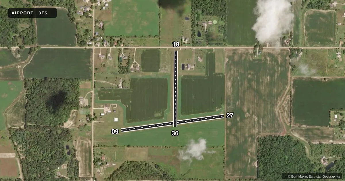
Airport sketch
Runways drawn to scale from FAA survey coordinates, rendered over satellite imagery. Not for navigation.
Approaches & charts
Services on the field
Fuel grades, oxygen, maintenance, ramp storage and lighting — as declared to the FAA by the airport operator.
Fuel & services
- Fuel
- Not available
- Oxygen (bottled)
- Not available
- Oxygen (bulk)
- Not available
- Airframe repair
- Not available
- Power plant repair
- Not available
Ramp & ground
- Transient storage
- Tie-down
- Wind indicator
- Yes
- Segmented circle
- No
Fuel & FBOs
Cheapest 100LL and Jet A on the field and nearby. Always confirm with the FBO before taxi.
Airport notes
Surface conditions, obstructions, local procedures, lighting outages and other notes published with each FAA cycle.
General notes
- DEER & BIRDS ON & INVOF ARPT.
- FOR WINTER FICONS CALL AMGR.
- FOR CD CTC GREAT LAKES APCH AT 269-459-3345, WHEN APCH CLSD CTC CLEVELAND ARTCC AT 440-774-0224/0490.
Approach & departure obstructions
- 09RWY & DTHR MKD WITH 3 FT YELLOW CONES.
- 18RWY & DTHR MKD WITH 3 FT YELLOW CONES.
- 273 FT YELLOW CONES.
- 363 FT YELLOW CONES.
- 09APCH RATIO 20:1 TO DTHR.
- 18APCH RATIO 20:1 TO DTHR OVR +30 FT PLINE, 791 FT DIST, 125 FT L/R.
Other notes
- PRVDD OBST REMOVED/LWRD OR THR DSPLCD TO PRVD CLEAR 20:1 SLP; 125 FT EITHER SIDE OF CNTRLN & 200 FT EITHER END BE CLEAR.
VFR map & nearby airports
VFR sectional. Tap any ICAO chip to open that airport.
Key facts · 3F5
Answer card- ICAO
- 3F5
- Name
- FOREST HILL
- Location
- WESTPHALIA, MICHIGAN
- Elevation
- 772 ft MSL
- Traffic pattern altitude
- 1,772 ft MSL (1,000 AGL)
- Control tower
- Non-towered (use CTAF)
- Total runways
- 2
- Longest runway
- 09/27 · 2,070 ft
- Published ILS approaches
- 0
- Published frequencies
- 1
- Magnetic variation
- –
- Current flight rules
- IFR
- Current wind
- 230° at 13 kt
- Favored runway now
- RWY 27
Forest Hill Airport (3F5) sits in Westphalia, Michigan. Field elevation is 772 ft MSL. The airport has two turf runways. The longest is runway 09/27 at 2,070 ft. Runway 18/36 is 1,520 ft.
There is no control tower. CTAF is 122.9. No ILS approaches are published here. Plan for non-precision or visual work only. Verify current procedures before you go. The pattern altitude is not published. Use 1,000 ft AGL for light piston traffic unless the current Chart Supplement says otherwise. That puts the pattern at 1,772 ft MSL.
Published remarks matter here. Runway 09 has a displaced threshold and a 20 to 1 approach slope. Runways 09, 18, 27 and 36 use 3 foot yellow cones for marking. The Chart Supplement also notes deer and birds in the area. Winter field conditions should be checked with the airport manager before arrival.
No on-field FBOs are listed. Contact the airport operator directly before arrival if you need services. For clearance delivery, contact Great Lakes Approach. If approach is closed, contact Cleveland ARTCC. This is a small turf field with short runways. Pay close attention to wind, surface condition and obstacle clearance on final.