METAR & TAF M99
M99 does not publish a METAR.
Showing the nearest reporting station: KAMN (GRATIOT COMMUNITY) · 16.8 NM away. Conditions at M99 may differ.
METAR · KAMN
Observed 16:55Z
KAMN 261655Z AUTO VRB02KT 10SM BKN034 28/19 A2989 RMK AO2
- Wind
- VAR @ 2 kt
- Visibility
- 10 SM
- Temp / Dew
- 28°C / 19°C
- Altimeter
- 29.89 inHg
- Clouds
- BKN
- Density alt
- 2,440 ft
- Ceiling
- 3,400 ft AGL
- Rules
- VFR
Airport info & contacts
Manager on record, flight service, ARTCC, attendance schedule and pattern altitude — published by the FAA and refreshed every 28 days.
Location
- From city
- 4 NM N
- VFR sectional
- DETROIT
- ARTCC
- ZOB · CLEVELAND
- NOTAM facility
- LAN (NOTAM-D)
Airport manager
- Name
- EUGENE JONES
- Phone
- 517-282-1656
- Address
- 1550 W FRENCH RD, SAINT JOHNS MI 48879-9406
Flight service · Hours
- FSS LAN
- LANSING1-800-WX-BRIEF
- Attendance
- Unattended
Frequencies
Tap any row to copy the frequency to your clipboard.
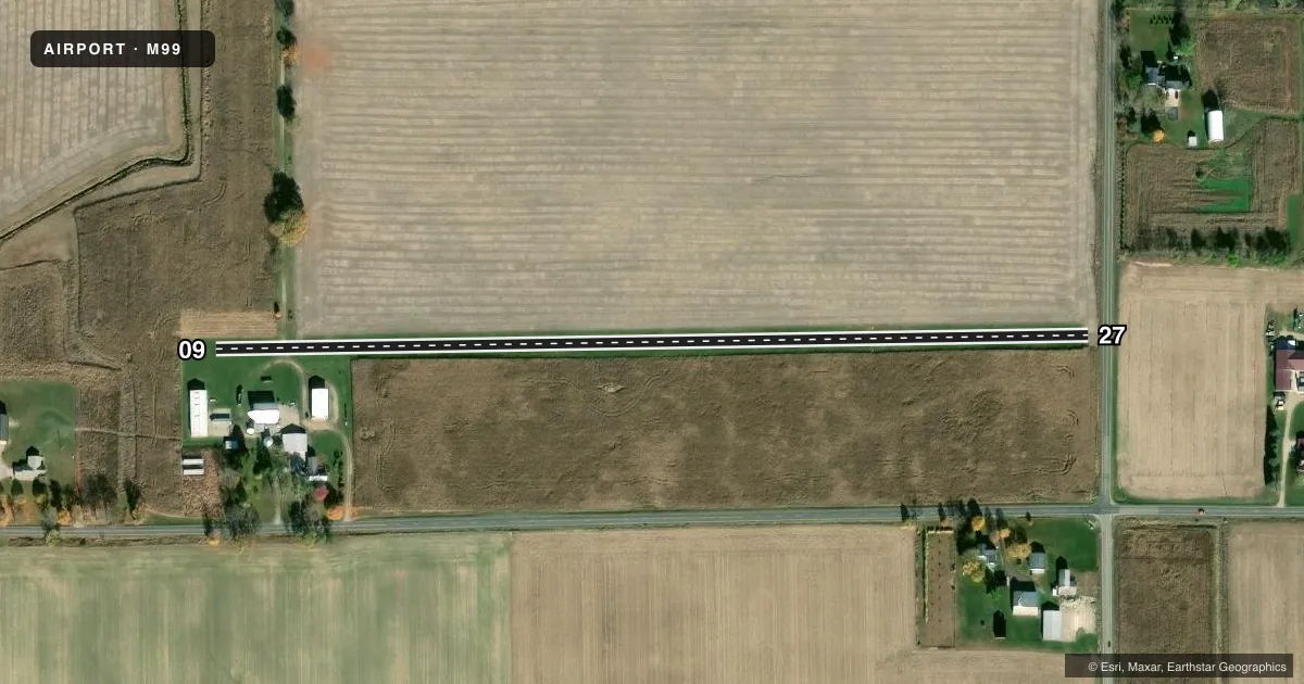
Runways & pattern
Full pagePattern entry · RWY 09
LEFT TRAFFICRunway end performance
| End | TORA | TODA | ASDA | LDA | VGSI | Approach lights | Obstruction |
|---|---|---|---|---|---|---|---|
| 09 | — | — | — | — | — | — | 50', tree, 560' from thr, 86' R of cntrln, slope 11 |
| 27 | — | — | — | — | — | — | 59', road, 18' from thr, 125' R of cntrln, slope 1 |
Declared distances in feet. TORA = takeoff run available, TODA = takeoff distance, ASDA = accelerate-stop, LDA = landing distance.
Airport sketch
Runways drawn to scale from FAA survey coordinates, rendered over satellite imagery. Not for navigation.
Approaches & charts
Services on the field
Fuel grades, oxygen, maintenance, ramp storage and lighting — as declared to the FAA by the airport operator.
Fuel & services
- Fuel
- Not available
Ramp & ground
- Transient storage
- Not published
Fuel & FBOs
Cheapest 100LL and Jet A on the field and nearby. Always confirm with the FBO before taxi.
Airport notes
Surface conditions, obstructions, local procedures, lighting outages and other notes published with each FAA cycle.
General notes
- FOR CD CTC GREAT LAKES APCH AT 269-459-3345, WHEN APCH CLSD CTC CLEVELAND ARTCC AT 440-774-0224/0490.
- DEER, BIRDS, & WILDLIFE ON & INVOF ARPT.
- OPPOSITE RWY END NOT VSB FM THR DUE TO ROLLING TRRN, +25 FT ELEV CHG.
- RWY 27 DTHR 1430 FT, EXTDS BYD RWY MIDPT.
Approach & departure obstructions
- 27APCH RATIO 20:1 TO DTHR.
VFR map & nearby airports
VFR sectional. Tap any ICAO chip to open that airport.
Key facts · M99
Answer card- ICAO
- M99
- Name
- SHADY LANE
- Location
- ST JOHNS, MICHIGAN
- Elevation
- 680 ft MSL
- Traffic pattern altitude
- 1,680 ft MSL (1,000 AGL)
- Control tower
- Non-towered (use CTAF)
- Total runways
- 1
- Longest runway
- 09/27 · 2,302 ft
- Published ILS approaches
- 0
- Published frequencies
- 1
- Magnetic variation
- –
- Current flight rules
- VFR
- Current wind
- 000° at 2 kt
- Favored runway now
- RWY 09
Shady Lane (M99) sits near St Johns, Michigan. The field elevation is 680 ft MSL. It has one runway. Runway 09/27 is 2,302 ft long and turf. The airport is not towered. CTAF is 122.9. No ILS approaches are published.
The pattern altitude is not published. Use the standard 1,000 ft AGL pattern unless the current Chart Supplement says otherwise. That puts the light aircraft pattern at 1,680 ft MSL based on the field elevation. Verify the published pattern before you go. There are no on-field FBOs listed, so plan fuel and services elsewhere or call ahead for current options.
The published remarks matter here. Deer, birds and other wildlife are present on and near the airport. Runway 27 has a displaced threshold of 1,430 ft. The opposite end is not visible from the threshold because of rolling terrain and a 25 ft elevation change. That makes a careful runway check important before landing or departing. For clearance delivery, contact Great Lakes Approach when available. When approach is closed, contact Cleveland ARTCC. This is a small, quiet field with a turf surface, so expect a simple VFR arrival and keep an eye out for wildlife and terrain on short final.