METAR & TAF 3S5
3S5 does not publish a METAR.
Showing the nearest reporting station: KRNP (OWOSSO COMMUNITY) · 13.2 NM away. Conditions at 3S5 may differ.
METAR · KRNP
Observed 13:35Z
KRNP 271335Z AUTO 23007KT 8SM BKN010 27/23 A2980 RMK AO2
- Wind
- 230° @ 7 kt
- Visibility
- 8 SM
- Temp / Dew
- 27°C / 23°C
- Altimeter
- 29.80 inHg
- Clouds
- BKN
- Density alt
- 2,508 ft
- Ceiling
- 1,000 ft AGL
- Rules
- MVFR
Airport info & contacts
Manager on record, flight service, ARTCC, attendance schedule and pattern altitude — published by the FAA and refreshed every 28 days.
Location
- From city
- 6 NM ENE
- VFR sectional
- DETROIT
- ARTCC
- ZOB · CLEVELAND
- NOTAM facility
- LAN (NOTAM-D)
Airport manager
- Name
- MICHAEL & ALBERT SCHIFFER
- Phone
- 989-834-5067
- Address
- 3473 N SHEPARDSVILLE RD, OVID MI 48866-9667
Flight service · Hours
- FSS LAN
- LANSING1-800-WX-BRIEF
- Attendance
- IREG
Frequencies
Tap any row to copy the frequency to your clipboard.
Runways & pattern
Full pagePattern entry · RWY 26
LEFT TRAFFICRunway end performance
| End | TORA | TODA | ASDA | LDA | VGSI | Approach lights | Obstruction |
|---|---|---|---|---|---|---|---|
| 26 | — | — | — | — | — | — | 50', trees, 0' from thr, 85' R of cntrln, slope 1 |
Declared distances in feet. TORA = takeoff run available, TODA = takeoff distance, ASDA = accelerate-stop, LDA = landing distance.
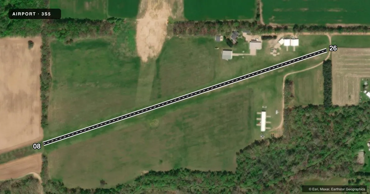
Airport sketch
Runways drawn to scale from FAA survey coordinates, rendered over satellite imagery. Not for navigation.
Approaches & charts
Services on the field
Fuel grades, oxygen, maintenance, ramp storage and lighting — as declared to the FAA by the airport operator.
Fuel & services
- Fuel
- Not available
- Airframe repair
- Not available
- Power plant repair
- Not available
- Other services
- AGRI
Ramp & ground
- Transient storage
- Tie-down
- Wind indicator
- Yes
- Segmented circle
- Yes
Fuel & FBOs
Cheapest 100LL and Jet A on the field and nearby. Always confirm with the FBO before taxi.
Airport notes
Surface conditions, obstructions, local procedures, lighting outages and other notes published with each FAA cycle.
General notes
- DEER, BIRDS, & WILDLIFE ON & INVOF ARPT.
- FOR CD CTC GREAT LAKES APCH AT 269-459-3345, WHEN APCH CLSD CTC CLEVELAND ARTCC AT 440-774-0224/0490.
Runway surface & condition
- 08/26LIRL NOT FOR PUBLIC USE.
Approach & departure obstructions
- 08RWY DEFINED BY MOWING.
- 26RWY DEFINED BY MOWING; DTHR MKD WITH 3 YELLOW CONES EACH SIDE OF RWY.
- 26APCH RATIO 8:1 OVR +47 FT TREE, 381 FT DIST, 80 FT L; 20:1 TO DTHR.
- 26ALSO +32 FT PLINE, 510 FT DIST, 25 FT L.
VFR map & nearby airports
VFR sectional. Tap any ICAO chip to open that airport.
Key facts · 3S5
Answer card- ICAO
- 3S5
- Name
- SCHIFFER ACRES
- Location
- ST JOHNS, MICHIGAN
- Elevation
- 741 ft MSL
- Traffic pattern altitude
- 1,741 ft MSL (1,000 AGL)
- Control tower
- Non-towered (use CTAF)
- Total runways
- 1
- Longest runway
- 08/26 · 2,777 ft
- Published ILS approaches
- 0
- Published frequencies
- 1
- Magnetic variation
- –
- Current flight rules
- MVFR
- Current wind
- 230° at 7 kt
- Favored runway now
- RWY 26
Schiffer Acres is in St Johns, Michigan. The field elevation is 741 ft MSL. It has one runway. The longest runway is 08/26 at 2,777 ft on turf. There is no control tower. CTAF is 122.9. No ILS approaches are published here.
Pattern altitude is not published. Use 1,000 ft AGL for light piston operations unless the current Chart Supplement says otherwise. Runway 08 is defined by mowing. Runway 26 is also defined by mowing. The displaced threshold on 26 is marked with yellow cones on each side. Low intensity runway lighting is listed. It is not for public use.
There are no on-field FBOs listed. Check with the airport operator or the FBO directly by phone before arrival if you need fuel or services. The published remarks also call out deer, birds and other wildlife in the area. There are obstruction notes on the 26 end. A 47-foot tree sits near the approach path. There is also a 32-foot power line near the threshold. Plan a careful look at the runway environment before you commit, especially if you are new to turf or arriving at dusk.