METAR & TAF 41G
41G does not publish a METAR.
Showing the nearest reporting station: KLAN (CAPITAL REGION INTL) · 6.0 NM away. Conditions at 41G may differ.
METAR · KLAN
Observed 13:31Z
KLAN 271331Z 23013KT 7SM FU BKN009 25/23 A2984 RMK AO2 T02500228 $
- Wind
- 230° @ 13 kt
- Visibility
- 7 SM
- Temp / Dew
- 25°C / 23°C
- Altimeter
- 29.84 inHg
- Clouds
- BKN
- Density alt
- 2,361 ft
- Ceiling
- 900 ft AGL
- Rules
- IFR
Airport info & contacts
Manager on record, flight service, ARTCC, attendance schedule and pattern altitude — published by the FAA and refreshed every 28 days.
Location
- From city
- 2 NM NW
- VFR sectional
- DETROIT
- ARTCC
- ZOB · CLEVELAND
- NOTAM facility
- LAN (NOTAM-D)
Airport manager
- Name
- GAYLAND TENNIS
- Phone
- 517-881-6360
- Address
- 4100 HOWE RD, BATH MI 48808-8482
Flight service · Hours
- FSS LAN
- LANSING1-800-WX-BRIEF
- Attendance
- IREG
Frequencies
Tap any row to copy the frequency to your clipboard.
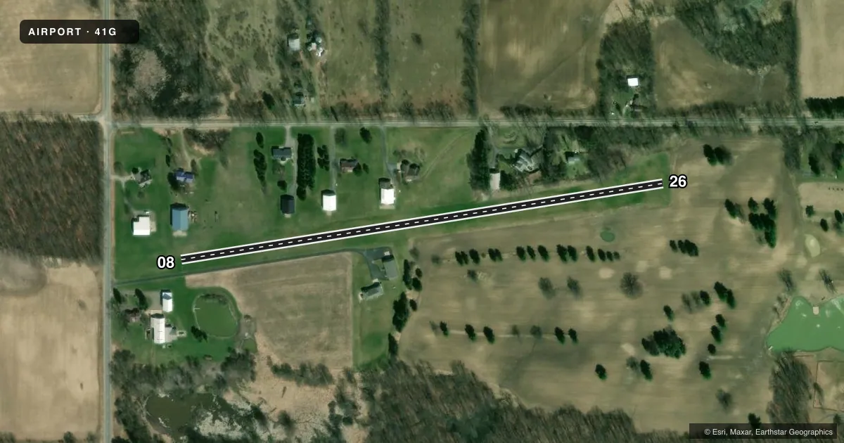
Runways & pattern
Full pagePattern entry · RWY 26
LEFT TRAFFICRunway end performance
| End | TORA | TODA | ASDA | LDA | VGSI | Approach lights | Obstruction |
|---|---|---|---|---|---|---|---|
| 08 | — | — | — | — | — | — | 69', trees, 337' from thr, 60' R of cntrln, slope 4 |
| 26 | — | — | — | — | — | — | 39', tree, 234' from thr, 120' R of cntrln, slope 6 |
Declared distances in feet. TORA = takeoff run available, TODA = takeoff distance, ASDA = accelerate-stop, LDA = landing distance.
Airport sketch
Runways drawn to scale from FAA survey coordinates, rendered over satellite imagery. Not for navigation.
Approaches & charts
Services on the field
Fuel grades, oxygen, maintenance, ramp storage and lighting — as declared to the FAA by the airport operator.
Fuel & services
- Fuel
- Not available
- Oxygen (bottled)
- Not available
- Oxygen (bulk)
- Not available
- Airframe repair
- Not available
- Power plant repair
- Not available
Ramp & ground
- Transient storage
- Tie-down
- Landing fee
- No fee published
- Customs
- Not available
- Wind indicator
- Yes
- Segmented circle
- No
Fuel & FBOs
Cheapest 100LL and Jet A on the field and nearby. Always confirm with the FBO before taxi.
Airport notes
Surface conditions, obstructions, local procedures, lighting outages and other notes published with each FAA cycle.
General notes
- TREES & HNGRS IN PRI SFC.
- DEER & LRG BIRDS ON & INVOF ARPT.
- FOR CD CTC GREAT LAKES APCH AT 269-459-3345, WHEN APCH CLSD CTC CLEVELAND ARTCC AT 440-774-0224/0490.
Approach & departure obstructions
- 083 FT YELLOW CONES.
- 263 FT YELLOW CONES.
- 26APCH RATIO 20:1 TO DTHR.
Other notes
- TIEDOWNS NOT PRVDD.
- 08/26OCNL SOFT/WET AREAS AT EAST END DURG SPRING THAW & AFT HVY RAIN.
VFR map & nearby airports
VFR sectional. Tap any ICAO chip to open that airport.
Key facts · 41G
Answer card- ICAO
- 41G
- Name
- UNIVERSITY AIRPARK
- Location
- BATH, MICHIGAN
- Elevation
- 856 ft MSL
- Traffic pattern altitude
- 1,856 ft MSL (1,000 AGL)
- Control tower
- Non-towered (use CTAF)
- Total runways
- 1
- Longest runway
- 08/26 · 1,994 ft
- Published ILS approaches
- 0
- Published frequencies
- 1
- Magnetic variation
- 5°
- Current flight rules
- IFR
- Current wind
- 230° at 13 kt
- Favored runway now
- RWY 26
University Airpark (41G) sits in Bath, Michigan. Field elevation is 856 ft MSL. The airport has one runway. Runway 08/26 is 1,994 ft of turf, which makes this a short-field stop for light aircraft. It is a non-towered field. CTAF is 122.9. No ILS approaches are published. Pattern altitude is not published, so use the standard 1,000 ft AGL for light piston traffic unless the current FAA Chart Supplement says otherwise.
The published remarks matter here. Expect occasional soft or wet turf at the east end during spring thaw or after heavy rain. Trees and hangars are in the primary surface. Deer and large birds are reported on and near the airport. Three-foot yellow cones mark the ends of both runway 08 and runway 26. The runway 26 approach has a 20 to 1 ratio to the displaced threshold. Plan your descent and aiming point carefully.
No on-field FBOs are listed. Tiedowns are not provided. For clearance delivery, contact Great Lakes Approach at 269-459-3345. If approach is closed, contact Cleveland ARTCC at 440-774-0224 or 440-774-0490. A first-time pilot should verify the current Chart Supplement before departure. Brief the turf condition, obstacle environment and wildlife risk before arrival.