METAR & TAF KFPK
Current METAR
Observed 15:15Z
KFPK 271515Z AUTO 25009G15KT 10SM CLR 25/21 A2985 RMK AO2 PRESRR
- Wind
- 250° @ 9G15 kt
- Visibility
- 10 SM
- Temp / Dew
- 25°C / 21°C
- Altimeter
- 29.85 inHg
- Clouds
- CLR
- Density alt
- 2,392 ft
- Ceiling
- Unlimited
- Rules
- VFR
Airport info & contacts
Manager on record, flight service, ARTCC, attendance schedule and pattern altitude — published by the FAA and refreshed every 28 days.
Location
- From city
- 1 NM NE
- VFR sectional
- DETROIT
- ARTCC
- ZOB · CLEVELAND
- NOTAM facility
- FPK (NOTAM-D)
Airport manager
- Name
- TODD COTTER
- Phone
- 517-712-8177
- Address
- 1325 ISLAND HWY, CHARLOTTE MI 48813-9358
Flight service · Hours
- FSS LAN
- LANSING1-800-WX-BRIEF
- Attendance
- MON-FRI · 0800-1700
- SAT-SUN · ON CALL
Frequencies
Tap any row to copy the frequency to your clipboard.
Runways & pattern
Full pagePattern entry · RWY 21
LEFT TRAFFIC| Runway | Heading (°M) | Length | Surface | Traffic |
|---|---|---|---|---|
| 03/21Favored | 15° / 195° | 3,510 ft | CONC | Standard L |
| 15/33 | 139° / 319° | 2,298 ft | TURF | Standard L |
Runway end performance
| End | TORA | TODA | ASDA | LDA | VGSI | Approach lights | Obstruction |
|---|---|---|---|---|---|---|---|
| 03 | — | — | — | — | PAPI 4-box left(4°) | — | 8', brush, 345' from thr, 259' R of cntrln, slope 18 |
| 21 | — | — | — | — | PAPI 4-box left(4°) | — | 41', tree, 827' from thr, 300' R of cntrln, slope 15 |
| 15 | — | — | — | — | — | — | 18', tree, 145' from thr, 78' R of cntrln, slope 8 |
| 33 | — | — | — | — | — | — | 3', gnd, 0' from thr, 70' R of cntrln, slope 0 |
Declared distances in feet. TORA = takeoff run available, TODA = takeoff distance, ASDA = accelerate-stop, LDA = landing distance.
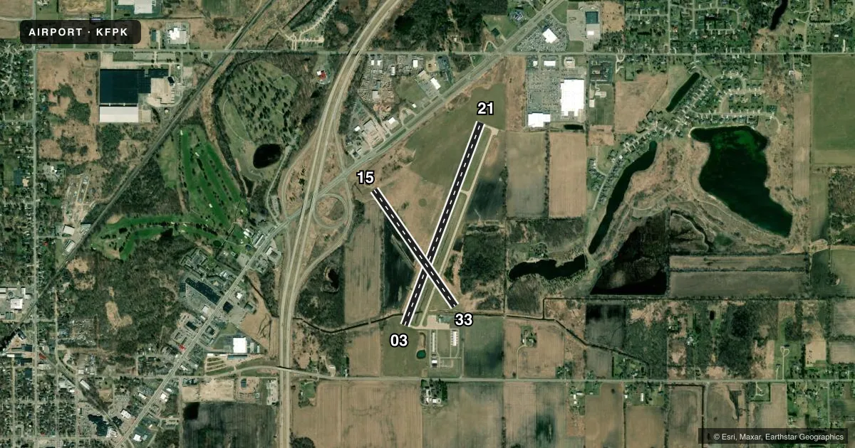
Airport sketch
Runways drawn to scale from FAA survey coordinates, rendered over satellite imagery. Not for navigation.
Approaches & charts
Services on the field
Fuel grades, oxygen, maintenance, ramp storage and lighting — as declared to the FAA by the airport operator.
Fuel & services
- Fuel
- 100LL
- Oxygen (bottled)
- Not available
- Oxygen (bulk)
- Not available
- Airframe repair
- Major
- Power plant repair
- Major
Ramp & ground
- Transient storage
- Tie-down
- Hangar
- Landing fee
- No fee published
- Customs
- Not available
- Lighting schedule
- SEE RMK
- Beacon schedule
- SS-SR
- Beacon
- White / Green (civil land)(WG)
- Wind indicator
- Lighted
- Segmented circle
- Yes
Fuel & FBOs
Cheapest 100LL and Jet A on the field and nearby. Always confirm with the FBO before taxi.
Airport notes
Surface conditions, obstructions, local procedures, lighting outages and other notes published with each FAA cycle.
General notes
- MIL HOP ON & INVOF ARPT SPCLY AT NGT.
- DEER & LRG BIRDS ON & INVOF ARPT.
- GND MOLES & WATERFOWL ON RWY 15/33.
- FOR CD CTC GREAT LAKES APCH AT 269-459-3345, WHEN APCH CLSD CTC CLEVELAND ARTCC AT 440-774-0224/0490.
- ACFT WO RADIO OPRG INVOF ARPT.
Lighting notes
- ACTVT REIL RWY 03/21; PAPI RWY 03 & 21; MIRL RWY 03/21 - CTAF.
Runway surface & condition
- 15/33CLSD DEC-MAR & WHEN SNOW COVD.
Approach & departure obstructions
- 15RWY & DTHR MKD WITH 3 FT YELLOW CONES.
- 33RWY & DTHR MKD WITH 3 FT YELLOW CONES.
- 15APCH RATIO 19:1 TO DTHR OVR +94 FT TREE, 1785 FT DIST, 50 FT L.
- 33CTLG OBSTN EXCEEDS A 45 DEG SLP. APCH RATIO 20:1 TO DTHR.
Other notes
- 2ARPT UNATNDD MAJ HOLS. FOR SVC WKENDS CALL AMGR.
VFR map & nearby airports
VFR sectional. Tap any ICAO chip to open that airport.
Key facts · KFPK
Answer card- ICAO
- KFPK
- Name
- FITCH H BEACH
- Location
- CHARLOTTE, MICHIGAN
- Elevation
- 891 ft MSL
- Traffic pattern altitude
- 1,891 ft MSL (1,000 AGL)
- Control tower
- Non-towered (use CTAF)
- Total runways
- 2
- Longest runway
- 03/21 · 3,510 ft
- Published ILS approaches
- 0
- Published frequencies
- 4
- Magnetic variation
- 6°
- Current flight rules
- VFR
- Current wind
- 250° at 9 kt
- Favored runway now
- RWY 21
Fitch H Beach Airport is in Charlotte, Michigan. The field elevation is 891 ft MSL. It has two runways. The longest is runway 03/21 at 3,510 ft of concrete. Runway 15/33 is 2,298 ft of turf.
There is no control tower. Great Lakes Approach and Departure use 118.65 and 226.4. CTAF and UNICOM are both 123.0. No ILS approaches are published here. The pattern altitude is not published. Use the standard 1,000 ft AGL for light piston traffic unless local procedures say otherwise. That puts the pattern at 1,891 ft MSL.
Charlotte Air Services is on the field. It carries 100LL. Call (517) 712-8177 for current service details. Runway 03/21 has PAPI and runway end identifier lights. Medium intensity runway lights on 03/21 are controlled by CTAF. Runway 15/33 is closed from December through March and when snow covered. Published remarks also note deer, large birds, ground moles, waterfowl and military helicopter traffic in the area. There is also a tree near the displaced threshold on runway 15 that affects the approach path. If you are planning a first visit, pay close attention to the runway 33 approach. Watch the non-towered traffic picture.