METAR & TAF 60G
60G does not publish a METAR.
Showing the nearest reporting station: KFPK (FITCH H BEACH) · 7.1 NM away. Conditions at 60G may differ.
METAR · KFPK
Observed 06:35Z
KFPK 270635Z AUTO 17002KT 1/4SM FG VV002 20/20 A2985 RMK AO2 VIS M1/4V5
- Wind
- 170° @ 2 kt
- Visibility
- 0.25 SM
- Temp / Dew
- 20°C / 20°C
- Altimeter
- 29.85 inHg
- Clouds
- VV
- Density alt
- 1,841 ft
- Ceiling
- 200 ft AGL
- Rules
- LIFR
Airport info & contacts
Manager on record, flight service, ARTCC, attendance schedule and pattern altitude — published by the FAA and refreshed every 28 days.
Location
- From city
- 4 NM N
- VFR sectional
- DETROIT
- ARTCC
- ZOB · CLEVELAND
- NOTAM facility
- LAN (NOTAM-D)
Airport manager
- Name
- KEITH GIBBS
- Phone
- 517-667-0182
- Address
- 9445 COLUMBIA HWY, EATON RAPIDS MI 48827-8357
Flight service · Hours
- FSS LAN
- LANSING1-800-WX-BRIEF
- Attendance
- Unattended
Frequencies
Tap any row to copy the frequency to your clipboard.
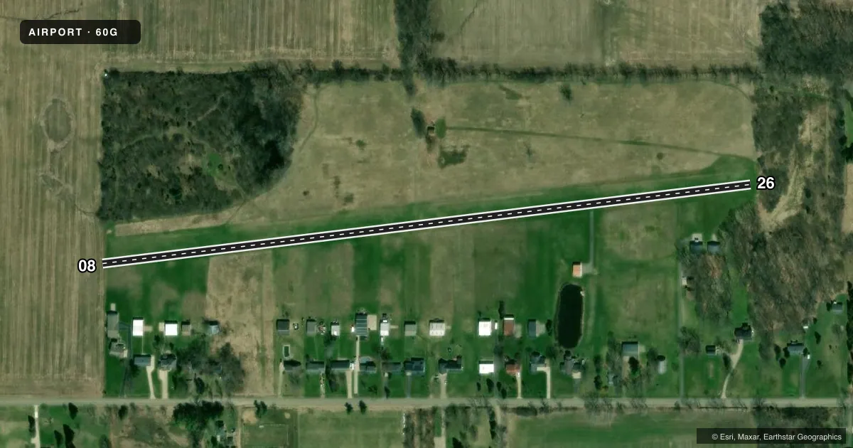
Runways & pattern
Full pagePattern entry · RWY 08
LEFT TRAFFICRunway end performance
| End | TORA | TODA | ASDA | LDA | VGSI | Approach lights | Obstruction |
|---|---|---|---|---|---|---|---|
| 08 | — | — | — | — | — | — | 45', trees, 0' from thr, 112' R of cntrln, slope 0 |
| 26 | — | — | — | — | — | — | 40', trees, 28' from thr, 21' R of cntrln, slope 0 |
Declared distances in feet. TORA = takeoff run available, TODA = takeoff distance, ASDA = accelerate-stop, LDA = landing distance.
Airport sketch
Runways drawn to scale from FAA survey coordinates, rendered over satellite imagery. Not for navigation.
Approaches & charts
Services on the field
Fuel grades, oxygen, maintenance, ramp storage and lighting — as declared to the FAA by the airport operator.
Fuel & services
- Fuel
- Not available
Ramp & ground
- Transient storage
- Not published
- Landing fee
- No fee published
- Lighting schedule
- SEE RMK
- Beacon schedule
- SEE RMK
- Beacon
- White / Green (civil land)(WG)
- Wind indicator
- Lighted
- Segmented circle
- No
Fuel & FBOs
Cheapest 100LL and Jet A on the field and nearby. Always confirm with the FBO before taxi.
Airport notes
Surface conditions, obstructions, local procedures, lighting outages and other notes published with each FAA cycle.
General notes
- UAS OPS SOUTH OF RWY 08/26.
- FOR CD CTC GREAT LAKES APCH AT 269-459-3345, WHEN APCH CLSD CTC CLEVELAND ARTCC AT 440-774-0224/0490.
Lighting notes
- ACTVT ROTG BCN - CTAF.
- ACTVT MIRL RWY 08/26 - CTAF.
Approach & departure obstructions
- 08RWY & DTHR MKD WITH 3 FT YELLOW CONES.
- 26RWY & DTHR MKD WITH 3 FT YELLOW CONES.
- 08CTLG OBSTN EXCEEDS A 45 DEG SLP.
- 26CTLG OBSTN EXCEEDS A 45 DEG SLP. APCH RATIO 12:1 TO DTHR BASED ON STRAIGHT OUT OVR 40 FT TREES, 460 FT DIST, 0 FT B.
Other notes
- 08/26SOFT WHEN WET - CALL AMGR TO VFY FICON.
VFR map & nearby airports
VFR sectional. Tap any ICAO chip to open that airport.
Key facts · 60G
Answer card- ICAO
- 60G
- Name
- SKYWAY ESTATES
- Location
- EATON RAPIDS, MICHIGAN
- Elevation
- 931 ft MSL
- Traffic pattern altitude
- 1,931 ft MSL (1,000 AGL)
- Control tower
- Non-towered (use CTAF)
- Total runways
- 1
- Longest runway
- 08/26 · 2,653 ft
- Published ILS approaches
- 0
- Published frequencies
- 3
- Magnetic variation
- 5°
- Current flight rules
- LIFR
- Current wind
- 170° at 2 kt
- Favored runway now
- RWY 08
Skyway Estates (60G) sits in Eaton Rapids, Michigan. The field elevation is 931 ft MSL. It has one runway. Runway 08/26 is 2,653 ft of turf, which makes runway length and surface condition the main planning items here.
This is an untowered field. CTAF is 122.9. Great Lakes Approach handles clearance delivery on 118.65 or 226.4. If approach is closed, the published remarks say to contact Cleveland ARTCC. No ILS approaches are published for 60G. The pattern altitude is not published. Use the standard 1,000 ft AGL for light piston operations unless the current Chart Supplement says otherwise.
The published remarks matter here. The runway and displaced thresholds are marked with 3 ft yellow cones on both ends. The runway surface is soft when wet, so check field conditions with the airport manager before you go. There are also cataloged obstructions on both approaches. Runway 26 has trees near the threshold. Runway 08 has trees closer in as well. That makes a stabilized approach important, especially with a turf strip and a 2,653 ft runway.
No on-field FBOs are listed. Verify services with the airport operator or the FBO directly by phone before arrival. Unmanned aircraft system operations occur south of runway 08/26, so keep that in mind during taxi, takeoff and landing planning.