METAR & TAF C88
C88 does not publish a METAR.
Showing the nearest reporting station: KRNP (OWOSSO COMMUNITY) · 9.5 NM away. Conditions at C88 may differ.
METAR · KRNP
Observed 13:15Z
KRNP 271315Z AUTO 23007KT 190V250 9SM OVC010 26/22 A2981 RMK AO2
- Wind
- 230° @ 7 kt
- Visibility
- 9 SM
- Temp / Dew
- 26°C / 22°C
- Altimeter
- 29.81 inHg
- Clouds
- OVC
- Density alt
- 2,358 ft
- Ceiling
- 1,000 ft AGL
- Rules
- MVFR
Airport info & contacts
Manager on record, flight service, ARTCC, attendance schedule and pattern altitude — published by the FAA and refreshed every 28 days.
Location
- From city
- 2 NM W
- VFR sectional
- DETROIT
- ARTCC
- ZOB · CLEVELAND
- NOTAM facility
- LAN (NOTAM-D)
Airport manager
- Name
- STEVE TKACZYK
- Phone
- 989-205-2800
- Address
- 15801 W RIDGE RD, OAKLEY MI 48649-8735
Flight service · Hours
- FSS LAN
- LANSING1-800-WX-BRIEF
- Attendance
- Unattended
Frequencies
Tap any row to copy the frequency to your clipboard.
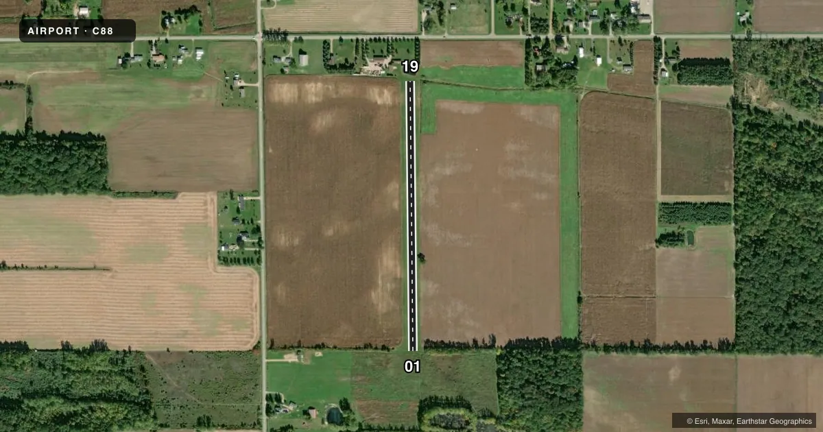
Runways & pattern
Full pagePattern entry · RWY 19
LEFT TRAFFICRunway end performance
| End | TORA | TODA | ASDA | LDA | VGSI | Approach lights | Obstruction |
|---|---|---|---|---|---|---|---|
| 01 | — | — | — | — | — | — | 28', tree, 176' from thr, 59' R of cntrln, slope 6 |
| 19 | — | — | — | — | — | — | 62', tree, 681' from thr, 25' R of cntrln, slope 10 |
Declared distances in feet. TORA = takeoff run available, TODA = takeoff distance, ASDA = accelerate-stop, LDA = landing distance.
Airport sketch
Runways drawn to scale from FAA survey coordinates, rendered over satellite imagery. Not for navigation.
Approaches & charts
Services on the field
Fuel grades, oxygen, maintenance, ramp storage and lighting — as declared to the FAA by the airport operator.
Fuel & services
- Fuel
- Not available
Ramp & ground
- Transient storage
- Not published
Fuel & FBOs
Cheapest 100LL and Jet A on the field and nearby. Always confirm with the FBO before taxi.
Airport notes
Surface conditions, obstructions, local procedures, lighting outages and other notes published with each FAA cycle.
General notes
- FOR CD CTC GREAT LAKES APCH AT 269-459-3345, WHEN APCH CLSD CTC CLEVELAND ARTCC AT 440-774-0224/0490.
- DEER & LRG BIRDS ON & INVOF ARPT.
Approach & departure obstructions
- 01RWY MKD WITH PVC PIPE & DTHR MKD WITH 18 IN SQUARE ORANGE PAVER.
- 19RWY MKD WITH PVC PIPE & DTHR MKD WITH 18 IN SQUARE ORANGE PAVER.
- 01APCH RATIO 20:1 TO DTHR.
- 19APCH RATIO 20:1 TO DTHR.
VFR map & nearby airports
VFR sectional. Tap any ICAO chip to open that airport.
Key facts · C88
Answer card- ICAO
- C88
- Name
- TKACZYK FLD
- Location
- OAKLEY, MICHIGAN
- Elevation
- 727 ft MSL
- Traffic pattern altitude
- 1,727 ft MSL (1,000 AGL)
- Control tower
- Non-towered (use CTAF)
- Total runways
- 1
- Longest runway
- 01/19 · 2,247 ft
- Published ILS approaches
- 0
- Published frequencies
- 1
- Magnetic variation
- –
- Current flight rules
- MVFR
- Current wind
- 230° at 7 kt
- Favored runway now
- RWY 19
TKACZYK FLD is in Oakley, Michigan. The field elevation is 727 ft MSL. It has one runway. The longest is Runway 01/19 at 2,247 ft on turf. There is no control tower. CTAF is 122.9.
No ILS approaches are published here. Pattern altitude is not published, so use the standard 1,000 ft AGL pattern unless the current Chart Supplement says otherwise. That puts the light aircraft pattern at about 1,727 ft MSL based on the field elevation, but verify before you fly.
Published remarks matter here. Both runway ends are marked with PVC pipe. The displaced thresholds are marked with 18-inch orange pavers. The approach path to the displaced threshold on both Runway 01 and Runway 19 has a 20 to 1 ratio note. Deer and large birds are reported on and near the airport, so keep a sharp scan on arrival and departure.
There are no on-field FBOs listed. FBO options vary. Contact the airport operator directly before arrival, or call the field on CTAF for current FBO availability. For clearance delivery, contact Great Lakes Approach at 269-459-3345. If Approach is closed, contact Cleveland ARTCC at 440-774-0224 or 440-774-0490.