METAR & TAF 4M4
4M4 does not publish a METAR.
Showing the nearest reporting station: KRNP (OWOSSO COMMUNITY) · 13.4 NM away. Conditions at 4M4 may differ.
METAR · KRNP
Observed 17:17Z
KRNP 271717Z AUTO 25011G17KT 10SM CLR 30/19 A2973 RMK AO2 PRESFR
- Wind
- 250° @ 11G17 kt
- Visibility
- 10 SM
- Temp / Dew
- 30°C / 19°C
- Altimeter
- 29.73 inHg
- Clouds
- CLR
- Density alt
- 2,883 ft
- Ceiling
- Unlimited
- Rules
- VFR
Airport info & contacts
Manager on record, flight service, ARTCC, attendance schedule and pattern altitude — published by the FAA and refreshed every 28 days.
Location
- From city
- 2 NM E
- VFR sectional
- DETROIT
- ARTCC
- ZOB · CLEVELAND
- NOTAM facility
- LAN (NOTAM-D)
Airport manager
- Name
- GREGORY GALKO
- Phone
- 989-640-8641
- Address
- 11367 S MASON RD, BANNISTER MI 48807-9753
Flight service · Hours
- FSS LAN
- LANSING1-800-WX-BRIEF
- Attendance
- Unattended
Frequencies
Tap any row to copy the frequency to your clipboard.
Runways & pattern
Full pagePattern entry · RWY 27
LEFT TRAFFICRunway end performance
| End | TORA | TODA | ASDA | LDA | VGSI | Approach lights | Obstruction |
|---|---|---|---|---|---|---|---|
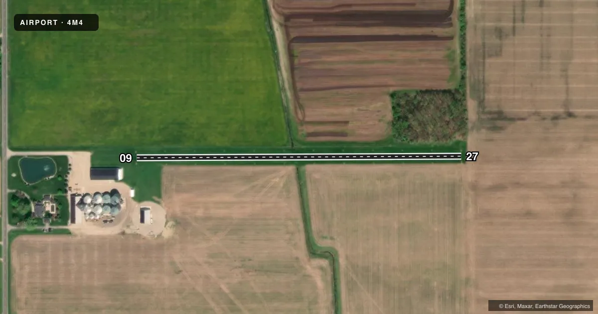
| 09 | — | — | — | — | — | — | 30', bldg, 162' from thr, 68' R of cntrln, slope 5 |
| 27 | — | — | — | — | — | — | 65', trees, 0' from thr, 120' R of cntrln, slope 0 |
Declared distances in feet. TORA = takeoff run available, TODA = takeoff distance, ASDA = accelerate-stop, LDA = landing distance.
Airport sketch
Runways drawn to scale from FAA survey coordinates, rendered over satellite imagery. Not for navigation.
Approaches & charts
Services on the field
Fuel grades, oxygen, maintenance, ramp storage and lighting — as declared to the FAA by the airport operator.
Fuel & services
- Fuel
- Not available
- Other services
- AGRI
Ramp & ground
- Transient storage
- Tie-down
- Wind indicator
- Yes
Fuel & FBOs
Cheapest 100LL and Jet A on the field and nearby. Always confirm with the FBO before taxi.
Airport notes
Surface conditions, obstructions, local procedures, lighting outages and other notes published with each FAA cycle.
General notes
- DEER & LRG BIRDS ON & INVOF ARPT.
- SEASONAL CROPS ADJ TO RWY.
- ULTRALIGHT & AGRICULTURAL ACT ON & INVOF ARPT.
- FOR CD CTC GREAT LAKES APCH AT 269-459-3345, WHEN APCH CLSD CTC CLEVELAND ARTCC AT 440-774-0224/0490.
Approach & departure obstructions
- 093 FT YELLOW CONES.
- 273 FT YELLOW CONES.
Other notes
- PRVDD ANY ENVIRONMENTAL ACTIONS ARE RESOLVED BFR CONST & COMPLY WITH NEPA.
VFR map & nearby airports
VFR sectional. Tap any ICAO chip to open that airport.
Key facts · 4M4
Answer card- ICAO
- 4M4
- Name
- SHADY LAWN FLD
- Location
- BANNISTER, MICHIGAN
- Elevation
- 683 ft MSL
- Traffic pattern altitude
- 1,683 ft MSL (1,000 AGL)
- Control tower
- Non-towered (use CTAF)
- Total runways
- 1
- Longest runway
- 09/27 · 1,865 ft
- Published ILS approaches
- 0
- Published frequencies
- 1
- Magnetic variation
- –
- Current flight rules
- VFR
- Current wind
- 250° at 11 kt
- Favored runway now
- RWY 27
Shady Lawn Fld is in Bannister, Michigan. Field elevation is 683 ft MSL. It has one runway. Runway 09/27 is 1,865 ft of turf. Plan for short-field performance and soft-field technique. No control tower is listed. CTAF is 122.9. No ILS approaches are published.
The pattern altitude is not published in the facts block. Use the current Chart Supplement before you go. The field sits in an area with deer, large birds, ultralight activity and agricultural traffic. Crops are adjacent to the runway in summer. Runway 09 has a cataloged obstruction that exceeds a 45 degree slope. The 09 end and 27 end are marked with 3 foot yellow cones.
No on-field FBOs are listed. If you need services, contact the airport operator directly before arrival. For clearance delivery, the published remark says to contact Great Lakes Approach at 269-459-3345. When approach is closed, contact Cleveland ARTCC at 440-774-0224 or 440-774-0490. This is a small turf strip with no published ILS. A first-time pilot should verify runway condition, wind and obstacle clearance before committing.