METAR & TAF KJYM
Current METAR
Observed 04:56Z
KJYM 270456Z AUTO 14001KT 1 1/4SM BR CLR 20/20 A2989 RMK AO2 VIS 3/4V5
- Wind
- 140° @ 1 kt
- Visibility
- 0.25 SM
- Temp / Dew
- 20°C / 20°C
- Altimeter
- 29.89 inHg
- Clouds
- CLR
- Density alt
- 2,106 ft
- Ceiling
- Unlimited
- Rules
- LIFR
Airport info & contacts
Manager on record, flight service, ARTCC, attendance schedule and pattern altitude — published by the FAA and refreshed every 28 days.
Location
- From city
- 2 NM E
- VFR sectional
- DETROIT
- ARTCC
- ZOB · CLEVELAND
- NOTAM facility
- JYM (NOTAM-D)
Airport manager
- Name
- TRAVIS STEBELTON
- Phone
- 517-797-4833
- Address
- 1727 AIRPORT RD, HILLSDALE MI 49242-0400
Flight service · Hours
- FSS LAN
- LANSING1-800-WX-BRIEF
- Attendance
- MON-FRI · 0800-1630
- SAT · 0800-1200
Frequencies
Tap any row to copy the frequency to your clipboard.
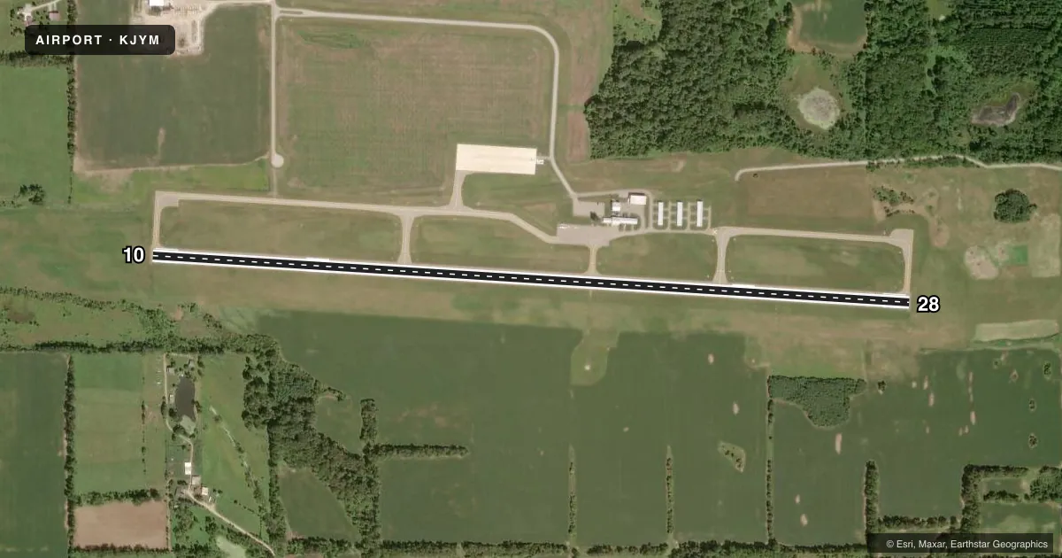
Runways & pattern
Full pagePattern entry · RWY 10
LEFT TRAFFICRunway end performance
| End | TORA | TODA | ASDA | LDA | VGSI | Approach lights | Obstruction |
|---|---|---|---|---|---|---|---|
| 10 | — | — | — | — | PAPI 4-box left(3°) | — | 14', tree, 553' from thr, 304' R of cntrln, slope 25 |
| 28 | — | — | — | — | PAPI 4-box left(3°) | — | 9', tree, 403' from thr, 282' R of cntrln, slope 22 |
Declared distances in feet. TORA = takeoff run available, TODA = takeoff distance, ASDA = accelerate-stop, LDA = landing distance.
Airport sketch
Runways drawn to scale from FAA survey coordinates, rendered over satellite imagery. Not for navigation.
Approaches & charts
Services on the field
Fuel grades, oxygen, maintenance, ramp storage and lighting — as declared to the FAA by the airport operator.
Fuel & services
- Fuel
- 100LLA
- Oxygen (bottled)
- Not available
- Oxygen (bulk)
- Not available
- Airframe repair
- Major
- Power plant repair
- Major
- Other services
- INSTR
Ramp & ground
- Transient storage
- Tie-down
- Hangar
- Landing fee
- No fee published
- Customs
- Not available
- Lighting schedule
- SEE RMK
- Beacon schedule
- SS-SR
- Beacon
- White / Green (civil land)(WG)
- Wind indicator
- Lighted
- Segmented circle
- No
Fuel & FBOs
Cheapest 100LL and Jet A on the field and nearby. Always confirm with the FBO before taxi.
Airport notes
Surface conditions, obstructions, local procedures, lighting outages and other notes published with each FAA cycle.
General notes
- DEER, LRG BIRDS, & WILDLIFE ON & INVOF ARPT.
- CTC AMGR FOR SNOW REMOVAL & ARPT CONDS.
- FOR CD CTC TOLEDO APCH AT 419-865-1495.
Lighting notes
- ACTVT REIL RWY 10 & 28; PAPI RWY 10 & 28; HIRL RWY 10/28 - CTAF.
Fuel notes
- 100LL100LL AVBL H24 SELF SVC.
- AJET A FUEL TRUCK AVBL FOR SNGL POINT FUELING WHEN ATNDD.
Other notes
- 1UNATNDD MAJOR HOLS.
VFR map & nearby airports
VFR sectional. Tap any ICAO chip to open that airport.
Key facts · KJYM
Answer card- ICAO
- KJYM
- Name
- HILLSDALE MUNI
- Location
- HILLSDALE, MICHIGAN
- Elevation
- 1,184.2 ft MSL
- Traffic pattern altitude
- 2,184.2 ft MSL (1,000 AGL)
- Control tower
- Non-towered (use CTAF)
- Total runways
- 1
- Longest runway
- 10/28 · 5,000 ft
- Published ILS approaches
- 0
- Published frequencies
- 4
- Magnetic variation
- 7°
- Current flight rules
- LIFR
- Current wind
- 140° at 1 kt
- Favored runway now
- RWY 10
Hillsdale Muni sits in Hillsdale, Michigan. The field elevation is 1,184.2 ft MSL. It has one runway, 10/28, which is 5,000 ft long. There is no control tower. Clearance delivery goes through Toledo Approach. The published frequencies include CTAF and UNICOM on 122.8. Approach and departure are on 134.35 and 317.55.
No ILS approaches are published here. Pattern altitude is not published, so use the standard 1,000 ft AGL for light piston traffic unless the current Chart Supplement says otherwise. The on-field FBO is Hillsdale Municipal Airport. It carries 100LL and Jet A Prist. 100LL is available 24 hours a day by self-service. Jet A is available by truck when attended.
The runway lighting setup is useful to know before a night arrival. Runway end identifier lights and PAPI are on both ends. High intensity runway lights are on runway 10/28 and are controlled by CTAF. The airport is unattended on major holidays. Wildlife is also a factor here. Deer, large birds and other wildlife are reported on and near the field. If you are planning in winter, call the airport manager for snow removal and current field conditions before you go.