METAR & TAF 3NP
3NP does not publish a METAR.
Showing the nearest reporting station: KJXN (JACKSON COUNTY/REYNOLDS FLD) · 10.5 NM away. Conditions at 3NP may differ.
METAR · KJXN
Observed 12:56Z
KJXN 271256Z 22009KT 5SM BR BKN006 23/22 A2988 RMK AO2 SLP112 T02330222
- Wind
- 220° @ 9 kt
- Visibility
- 5 SM
- Temp / Dew
- 23°C / 22°C
- Altimeter
- 29.88 inHg
- Clouds
- BKN
- Density alt
- 2,204 ft
- Ceiling
- 600 ft AGL
- Rules
- IFR
Airport info & contacts
Manager on record, flight service, ARTCC, attendance schedule and pattern altitude — published by the FAA and refreshed every 28 days.
Location
- From city
- 1 NM NW
- VFR sectional
- DETROIT
- ARTCC
- ZOB · CLEVELAND
- NOTAM facility
- LAN (NOTAM-D)
Airport manager
- Name
- SAMUEL OWEN KELLY
- Phone
- 734-353-7900
- Address
- 211 N UNION ST, TECUMSEH MI 49286-1342
Flight service · Hours
- FSS LAN
- LANSING1-800-WX-BRIEF
- Attendance
- Unattended
Frequencies
Tap any row to copy the frequency to your clipboard.
Runways & pattern
Full pagePattern entry · RWY 27
LEFT TRAFFIC| Runway | Heading (°M) | Length | Surface | Traffic |
|---|---|---|---|---|
| 09/27Favored | 85° / 265° | 2,740 ft | TURF | Standard L |
| 15/33 | 148° / 328° | 2,500 ft | TURF | Standard L |
Runway end performance
| End | TORA | TODA | ASDA | LDA | VGSI | Approach lights | Obstruction |
|---|---|---|---|---|---|---|---|
| 09 | — | — | — | — | — | — | 62', tree, 131' from thr, 0' R of cntrln, slope 1 |
| 27 | — | — | — | — | — | — | 24', tree, 15' from thr, 116' R of cntrln, slope 1 |
| 15 | — | — | — | — | — | — | 15', road, 0' from thr, 108' R of cntrln, slope 1 |
| 33 | — | — | — | — | — | — | 13', bldg, 96' from thr, 134' R of cntrln, slope 1 |
Declared distances in feet. TORA = takeoff run available, TODA = takeoff distance, ASDA = accelerate-stop, LDA = landing distance.
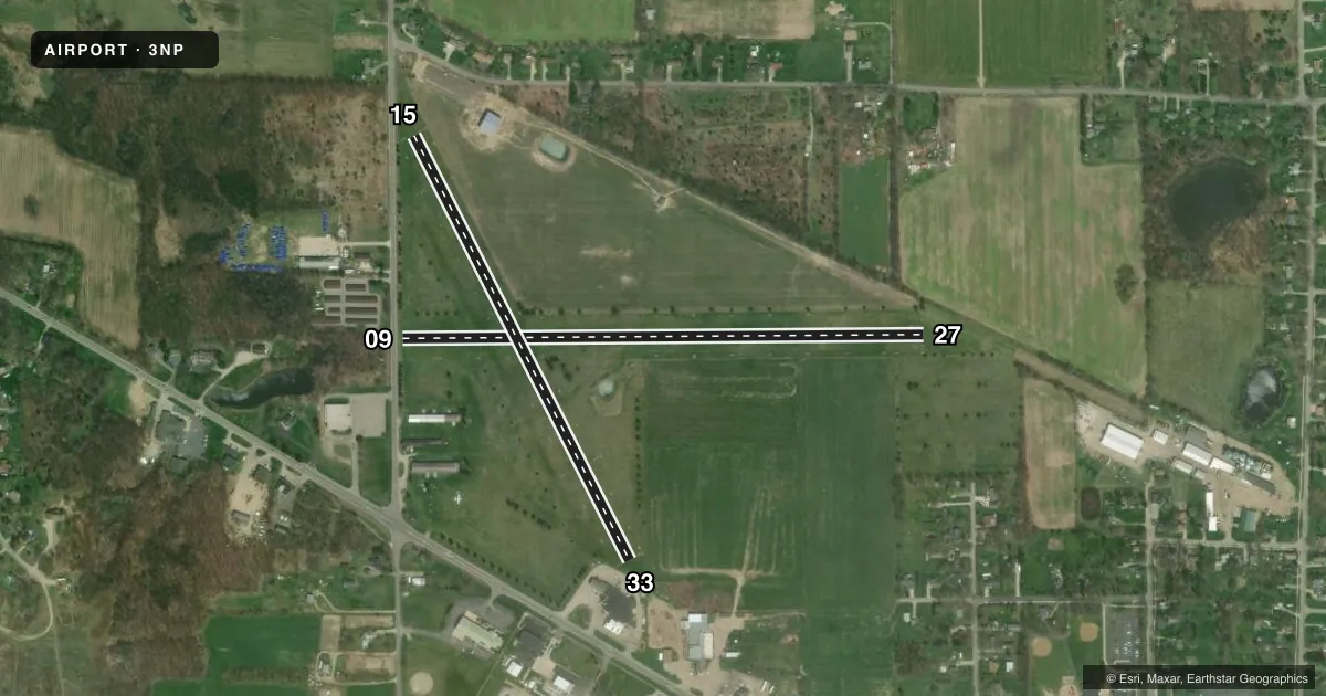
Airport sketch
Runways drawn to scale from FAA survey coordinates, rendered over satellite imagery. Not for navigation.
Approaches & charts
Services on the field
Fuel grades, oxygen, maintenance, ramp storage and lighting — as declared to the FAA by the airport operator.
Fuel & services
- Fuel
- Not available
- Oxygen (bottled)
- Not available
- Oxygen (bulk)
- Not available
- Airframe repair
- Not available
- Power plant repair
- Not available
- Other services
- PAJA
Ramp & ground
- Transient storage
- Tie-down
- Landing fee
- No fee published
- Customs
- Not available
- Wind indicator
- Yes
- Segmented circle
- Yes
Fuel & FBOs
Cheapest 100LL and Jet A on the field and nearby. Always confirm with the FBO before taxi.
Airport notes
Surface conditions, obstructions, local procedures, lighting outages and other notes published with each FAA cycle.
General notes
- OIL TANKS SOUTH OF ARPT.
- ULTRALIGHT OPS IN GRASS WEST OF RWY 15/33.
- DEER & LRG BIRDS ON & INVOF ARPT.
- FOR CD CTC GREAT LAKES APCH AT 269-459-3345, WHEN APCH CLSD CTC CLEVELAND ARTCC AT 440-774-0224/0490.
- RWY 09 DTHR 1537 FT, EXTDS BYD RWY MIDPT.
Runway surface & condition
- 09/27NOT PLOWED IN WINTER.
- 15/33NOT PLOWED IN WINTER.
Approach & departure obstructions
- 093 FT YELLOW CONES; DTHR MKD WITH 3 CONES EACH SIDE.
- 153 FT YELLOW CONES; DTHR MKD WITH 3 CONES EACH SIDE.
- 273 FT YELLOW CONES.
- 333 FT YELLOW CONES; DTHR MKD WITH 3 CONES EACH SIDE.
- 09APCH RATIO 17:1 TO DTHR OVR 111 FT TREE, 1971 FT DIST, 113 FT R.
- 15APCH RATIO 4:1 TO DTHR OVR 41 FT TREE, 183 FT DIST, 134 FT R.
- 33APCH RATIO 19:1 TO DTHR OVR 83 FT TREE, 1586 FT DIST, 207 FT L.
- 33ALSO +11 FT PARKED VEHICLES & +4 FT FENCE AT THR.
Other notes
- ESTABD BFR 1959.
- 09/27SOFT IN SPRING.
- 15/33SOFT IN SPRING.
VFR map & nearby airports
VFR sectional. Tap any ICAO chip to open that airport.
Key facts · 3NP
Answer card- ICAO
- 3NP
- Name
- NAPOLEON
- Location
- NAPOLEON, MICHIGAN
- Elevation
- 963 ft MSL
- Traffic pattern altitude
- 1,963 ft MSL (1,000 AGL)
- Control tower
- Non-towered (use CTAF)
- Total runways
- 2
- Longest runway
- 09/27 · 2,740 ft
- Published ILS approaches
- 0
- Published frequencies
- 1
- Magnetic variation
- 5°
- Current flight rules
- IFR
- Current wind
- 220° at 9 kt
- Favored runway now
- RWY 27
Napoleon Airport (3NP) sits in Napoleon, Michigan. Field elevation is 963 ft MSL. The airport has two turf runways. The longest is Runway 09/27 at 2,740 ft. Runway 15/33 is 2,500 ft. There is no control tower. CTAF is 122.9. No ILS approaches are published.
Pattern altitude is not published. Use the standard 1,000 ft AGL for light piston traffic unless the current FAA Chart Supplement says otherwise. That puts the pattern at 1,963 ft MSL based on the field elevation here. Runway 15 and Runway 33 have displaced thresholds marked by yellow cones. Runways 09/27 and 15/33 are not plowed in winter. Deer and large birds are reported on and near the airport. Ultralight activity also occurs in the grass west of Runway 15/33.
There are no on-field FBOs listed. Plan for self-sufficiency on the ground. The published remarks also note oil tanks south of the airport. If you need clearance delivery, contact Great Lakes Approach. When approach is closed, contact Cleveland ARTCC. For a first visit, pay close attention to the turf condition. Also watch the displaced thresholds and the tree obstructions on the 15 and 33 approaches. This is a small non-towered field, so verify current airport status and any local procedures before you go.