METAR & TAF 7N4
7N4 does not publish a METAR.
Showing the nearest reporting station: KADG (LENAWEE COUNTY) · 13.3 NM away. Conditions at 7N4 may differ.
METAR · KADG
Observed 12:53Z
KADG 271253Z AUTO 21006KT 5SM BR SCT044 22/21 A2989 RMK AO2 SLP115 T02220206
- Wind
- 210° @ 6 kt
- Visibility
- 5 SM
- Temp / Dew
- 22°C / 21°C
- Altimeter
- 29.89 inHg
- Clouds
- SCT
- Density alt
- 1,900 ft
- Ceiling
- Unlimited
- Rules
- MVFR
Airport info & contacts
Manager on record, flight service, ARTCC, attendance schedule and pattern altitude — published by the FAA and refreshed every 28 days.
Location
- From city
- 1 NM W
- VFR sectional
- DETROIT
- ARTCC
- ZOB · CLEVELAND
- NOTAM facility
- LAN (NOTAM-D)
Airport manager
- Name
- RICHARD R KUSSMAUL
- Phone
- 734-330-0554
- Address
- 12447 MATTHEWS HWY, CLINTON MI 49236-9709
Flight service · Hours
- FSS LAN
- LANSING1-800-WX-BRIEF
- Attendance
- IREG
Frequencies
Tap any row to copy the frequency to your clipboard.
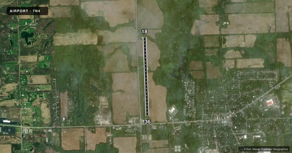
Runways & pattern
Full pagePattern entry · RWY 18
LEFT TRAFFICRunway end performance
| End | TORA | TODA | ASDA | LDA | VGSI | Approach lights | Obstruction |
|---|---|---|---|---|---|---|---|
| 18 | — | — | — | — | — | — | 40', trees, 0' from thr, 106' R of cntrln, slope 0 |
| 36 | — | — | — | — | — | — | 32', bldg, 129' from thr, 55' R of cntrln, slope 4 |
Declared distances in feet. TORA = takeoff run available, TODA = takeoff distance, ASDA = accelerate-stop, LDA = landing distance.
Airport sketch
Runways drawn to scale from FAA survey coordinates, rendered over satellite imagery. Not for navigation.
Approaches & charts
Services on the field
Fuel grades, oxygen, maintenance, ramp storage and lighting — as declared to the FAA by the airport operator.
Fuel & services
- Fuel
- Not available
Ramp & ground
- Transient storage
- Tie-down
- Wind indicator
- Yes
Fuel & FBOs
Cheapest 100LL and Jet A on the field and nearby. Always confirm with the FBO before taxi.
Airport notes
Surface conditions, obstructions, local procedures, lighting outages and other notes published with each FAA cycle.
General notes
- BLDG & HNGR IN PRI SFC.
- RWY 36, +18 FT PLINE 430 FT FROM THR MKD WITH ORANGE BALLS.
- FOR CD CTC DETROIT APCH AT 734-955-1404.
- DEER & BIRDS ON & INVOF ARPT.
Approach & departure obstructions
- 183 FT YELLOW CONES.
- 36RWY & DTHR MKD WITH 3 FT YELLOW CONES.
- 36APCH RATIO 8:1 TO DTHR OVR 80 FT TREE, 714 FT DIST, 125 FT L.
Other notes
- PRVDD CLR OFZ & CLR 20:1 APCH SFC.
- TIEDOWNS NOT PRVDD.
- 18/36SOFT DURG SPRING THAW & AFT HVY RAIN.
VFR map & nearby airports
VFR sectional. Tap any ICAO chip to open that airport.
Key facts · 7N4
Answer card- ICAO
- 7N4
- Name
- RAYMOND L KUSSMAUL JR MEML
- Location
- CLINTON, MICHIGAN
- Elevation
- 825 ft MSL
- Traffic pattern altitude
- 1,825 ft MSL (1,000 AGL)
- Control tower
- Non-towered (use CTAF)
- Total runways
- 1
- Longest runway
- 18/36 · 3,800 ft
- Published ILS approaches
- 0
- Published frequencies
- 1
- Magnetic variation
- 4°
- Current flight rules
- MVFR
- Current wind
- 210° at 6 kt
- Favored runway now
- RWY 18
Raymond L Kussmaul Jr Meml Airport sits in Clinton, Michigan. Field elevation is 825 ft MSL. The airport has one runway. Runway 18/36 is 3,800 ft of turf, with magnetic headings of 178° and 358°. There is no control tower. CTAF is 122.9. No ILS approaches are published here.
Pattern altitude is not published. Use 1,000 ft AGL for light piston operations unless the current Chart Supplement says otherwise. That puts the standard pattern at 1,825 ft MSL based on the field elevation, but verify before you fly. The published remarks matter here. The runway can get soft in spring thaw and after heavy rain. Deer and birds are reported on and near the airport. Buildings and hangars sit in the primary surface. Runway 36 also has an 18 ft power line near the threshold, marked with orange balls. Runway 36 and the displaced threshold are marked with 3 ft yellow cones.
No on-field FBOs are listed. Contact the airport operator directly or call the field on CTAF for current services before arrival. For clearance delivery, Detroit Approach is listed in the remarks. If you are planning a first visit, treat this as a turf field with weather-sensitive surface conditions and pay close attention to the obstacle notes on the 36 end.