METAR & TAF 34G
34G does not publish a METAR.
Showing the nearest reporting station: KADG (LENAWEE COUNTY) · 9.4 NM away. Conditions at 34G may differ.
METAR · KADG
Observed 18:53Z
KADG 271853Z AUTO VRB06KT 10SM CLR 28/21 A2982 RMK AO2 SLP094 T02780211
- Wind
- VAR @ 6 kt
- Visibility
- 10 SM
- Temp / Dew
- 28°C / 21°C
- Altimeter
- 29.82 inHg
- Clouds
- CLR
- Density alt
- 2,701 ft
- Ceiling
- Unlimited
- Rules
- VFR
Airport info & contacts
Manager on record, flight service, ARTCC, attendance schedule and pattern altitude — published by the FAA and refreshed every 28 days.
Location
- From city
- 3 NM SE
- VFR sectional
- DETROIT
- ARTCC
- ZOB · CLEVELAND
- NOTAM facility
- LAN (NOTAM-D)
Airport manager
- Name
- JEFF WRIGHT
- Phone
- 517-423-7600
- Address
- 5763 N. ROGERS HIGHWAY, TECUMSEH MI 49286
Flight service · Hours
- FSS LAN
- LANSING1-800-WX-BRIEF
- Attendance
- 0900-1700
Frequencies
Tap any row to copy the frequency to your clipboard.
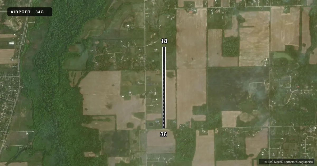
Runways & pattern
Full pagePattern entry · RWY 36
LEFT TRAFFICRunway end performance
| End | TORA | TODA | ASDA | LDA | VGSI | Approach lights | Obstruction |
|---|---|---|---|---|---|---|---|
| 18 | — | — | — | — | — | — | 57', tree, 472' from thr, 172' R of cntrln, slope 8 |
| 36 | — | — | — | — | — | — | 4', fence, 6' from thr, 126' R of cntrln, slope 1 |
Declared distances in feet. TORA = takeoff run available, TODA = takeoff distance, ASDA = accelerate-stop, LDA = landing distance.
Airport sketch
Runways drawn to scale from FAA survey coordinates, rendered over satellite imagery. Not for navigation.
Approaches & charts
Services on the field
Fuel grades, oxygen, maintenance, ramp storage and lighting — as declared to the FAA by the airport operator.
Fuel & services
- Fuel
- 100LL
- Airframe repair
- Major
- Power plant repair
- Major
Ramp & ground
- Transient storage
- Tie-down
- Landing fee
- No fee published
- Lighting schedule
- SS-SR
- Beacon schedule
- SEE RMK
- Beacon
- White(W)
- Wind indicator
- Yes
- Segmented circle
- No
Fuel & FBOs
Cheapest 100LL and Jet A on the field and nearby. Always confirm with the FBO before taxi.
Airport notes
Surface conditions, obstructions, local procedures, lighting outages and other notes published with each FAA cycle.
General notes
- ULTRALIGHT ACTIVITY ON & INVOF ARPT.
- RY 18/36 OPP RY END NOT VISIBLE FM TH.
- FOR CD CTC DETROIT APCH AT 734-955-1404.
Lighting notes
- ABN OTS INDEFLY.
Runway surface & condition
- 18/36LIRL NOT FOR PUBLIC USE.
Approach & departure obstructions
- 1818/36 MKD WITH CONES; DSPLCD THLD MKD WITH THREE 3 FT YELLOW CONES EACH SIDE.
- 18APCH RATIO 10:1 TO DTHR OVR 82 FT TREE, 830 FT DIST, 208 FT R.
- 36APCH RATIO 9:1 TO DTHR OVR 54 FT TREE, 486 FT DIST, 160 FT L.
Other notes
- PRVDD ALL TFC PTN OPNS CONDD EAST OF N/S RWY, VFR WX CONDS ONLY.
VFR map & nearby airports
VFR sectional. Tap any ICAO chip to open that airport.
Key facts · 34G
Answer card- ICAO
- 34G
- Name
- MERILLAT
- Location
- TECUMSEH, MICHIGAN
- Elevation
- 820 ft MSL
- Traffic pattern altitude
- 1,820 ft MSL (1,000 AGL)
- Control tower
- Non-towered (use CTAF)
- Total runways
- 1
- Longest runway
- 18/36 · 3,608 ft
- Published ILS approaches
- 0
- Published frequencies
- 2
- Magnetic variation
- 5°
- Current flight rules
- VFR
- Current wind
- 000° at 6 kt
- Favored runway now
- RWY 36
Merillat Airport (34G) sits in Tecumseh, Michigan. The field elevation is 820 ft MSL. It has one runway, 18/36, which is 3,608 ft of turf. There is no control tower. CTAF and UNICOM are both 122.8.
No ILS approaches are published here. The pattern altitude is not published, so plan on the standard 1,000 ft AGL for light piston operations unless the current FAA Chart Supplement says otherwise. Published remarks matter here. The rotating beacon is out of service indefinitely. Low intensity runway lighting is not for public use. Ultralight activity occurs on and near the airport. Runway 18 and 36 are marked with cones. The displaced threshold is marked with three 3-foot yellow cones on each side.
The runway environment deserves a careful look. The published remarks also note trees near both approach paths. Runway 18 has an 82-foot tree 830 feet from the threshold. Runway 36 has a 54-foot tree 486 feet from the threshold. Traffic pattern operations are on the east side of the north-south runway under VFR weather conditions only. The opposite runway end is not visible from the threshold. There are no on-field FBOs listed, so contact the airport operator directly or call the field on CTAF for current service details before you go.